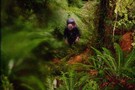
Nearby
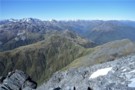
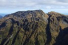
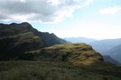
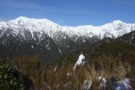
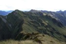
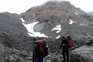
Kellys Range & beyond from Kellys Hill July 2011
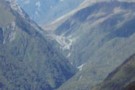
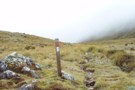
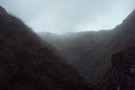
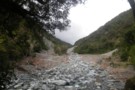
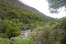
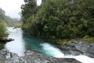
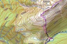
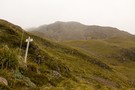
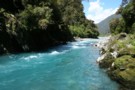
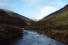
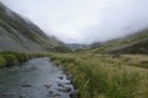
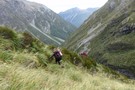
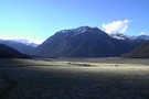
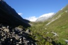
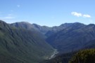
Arthur's Pass
Photograph
•
Distance: less than 100m away
Arthiur's pass and the viaduct viewed from the Kelly Creek to Carroll's Hut track.
More ▶︎
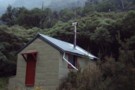
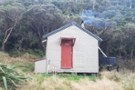
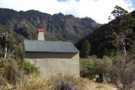
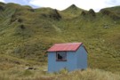
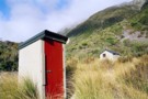
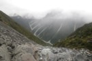
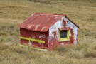
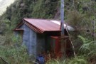
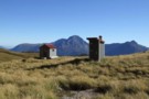
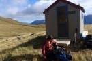
Carroll Memorial Hut
Photograph
•
Distance: less than 100m away
Situated on Kelly Saddle, Carroll Hut has stunning views across to Arthur's Pass.
More ▶︎
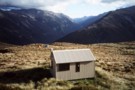
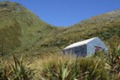
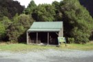
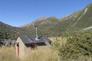
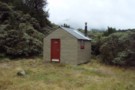
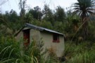
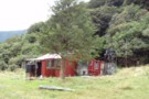
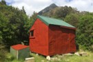
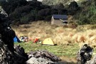
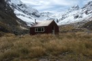
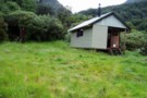
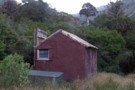
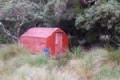
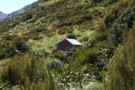
Carroll Hut
Photograph
•
Distance: less than 100m away
This newly renovated hut sits on a pretty tussock plateau on the Kelly Range.
More ▶︎

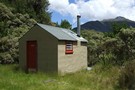
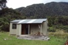
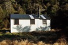
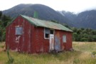
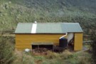
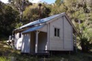
Carroll Hut
Hut
•
Standard Hut (DOC). Capacity: 10.
•
Distance: less than 100m away
A small, tidy hut just above the treeline on the Kelly Range. Recently renovated with new cladding and new windows. ...
More ▶︎
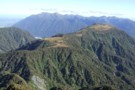
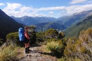
Kelly Range
Track
•
1 – 2 days. Medium. Return by the same track.
•
Distance: less than 100m away
A brief climb up to Carroll Hut on the tops at the northern edge of Arthur's Pass National Park. Magnificent ...
More ▶︎
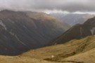
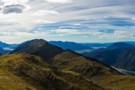
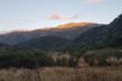
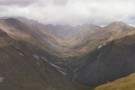
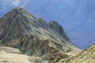
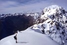
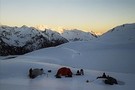
Catching the dawn on the Kelly range
Photograph
•
Distance: less than 100m away
The morning light on the Kelly range before it reaches the valley with Arthurs Pass
More ▶︎
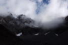
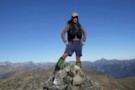
View south from Mt Tara Tama
Photograph
•
Distance: less than 100m away
This photo shows a large expanse of Westland back country and some peaks on the Canterbury side of the main ...
More ▶︎
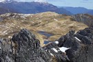
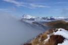
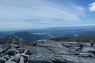
Kellys Hill
Photograph
•
Distance: less than 100m away
1400m above, looking NW from Kellys Hill, APNP.
More ▶︎
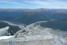
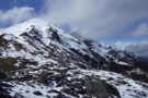
Mt Pfeifer etc from Kellys Hill July 2011
Photograph
•
Distance: less than 100m away
This photo was taken from near the broadcasting repeaters on top of Kellys Hill which is the hill immediately north ...
More ▶︎
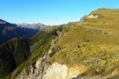
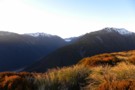
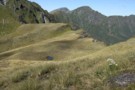
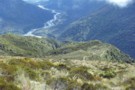
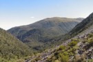
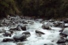
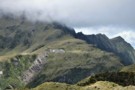
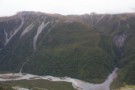
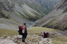
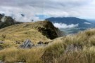
Kelly Range views over Kelly Ck
Photograph
•
Distance: less than 100m away
Moving southward above Carroll hut on the Kelly Range.
Descending the range to Hunts saddle and returning by Kellys Creek resulted ...
More ▶︎

Route Guide: Otira to Mt Cook Village (pt 2)
Track
•
12 – 21 days. Hard. One way.
•
Distance: 422m away
One possible route down the main divide from Otira on the Arthur's Pass road to Mt Cook Village.
Otira Hotel ...
More ▶︎
Route Guide: Otira to Mt Cook Village (pt 1)
Track
•
12 – 21 days. Hard. One way.
•
Distance: 422m away
One possible route down the main divide from Otira on the Arthur's Pass road to Mt Cook Village.
Otira Hotel to ...
More ▶︎
Kelly Range - Hunts Saddle Circuit
Track
•
2 – 3 days. Medium/hard. Loop track.
•
Distance: 508m away
A challenging circuit route traversing the Kelly Range and returning along Kelly's Creek. The direction described is the easiest option.
More ▶︎
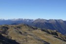
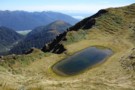
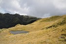
Kellys Saddle
Photograph
•
Distance: 508m away
Kellys Saddle - a tussock saddle between the Otira and Taipo near Carroll Hut
More ▶︎

Arthur's Pass National Park
Place
•
National Park. 1145.00km2.
•
Distance: 508m away
This alpine park straddles the Main Divide of the Southern Alps, with dry beech forests in the east and damp ...
More ▶︎
Scottys biv Jan 2010
Photograph
•
Distance: 1.4km away
A seldom walked to biv in a nice spot in the head basin of Scottys Creek a Taipo River tributary. ...
More ▶︎
Scottys biv
Hut
•
Basic Hut/Bivvy (DOC). Capacity: 2.
•
Distance: 1.4km away
A seldom walked to biv in a nice spot in the head basin of Scottys Creek a Taipo River tributary. ...
More ▶︎
Tarn on Tara Tama Range
Photograph
•
Distance: 1.6km away
This Westland range has many nice tarns. This is one of the nicer ones IMO. It is situated on the ...
More ▶︎
Lake Kaniere - Otira
GPX file
•
Distance: 1.6km away
from the north end of Lake Kaniere, along the west shore to the Styx river. East along the Styx to ...
More ▶︎
Dunns Creek Hut
Hut
•
Standard Hut (DOC). Capacity: 4.
•
Distance: 1.7km away
Dunns Creek Hut (4 bunks, stove, limited dry firewood, tank & creek water, mattresses). The hut sits at the back ...
More ▶︎
Dunns Creek
Photograph
•
Distance: 1.7km away
Dunns Creek, rough scrub on the ascent to Newton Saddle
More ▶︎
Kelly Shelter (Removed)
Hut
•
Removed!
•
Distance: 1.7km away
Kelly shelter is a roadside shelter on the Arthur's Pass road, at the base of Kelly's Creek and the track ...
More ▶︎
Hunts Creek Track
Track
•
2 days. Medium. Return via same track.
•
Distance: 1.7km away
Rough travel to a small, tidy hut. Better walked as part of a circuit.
More ▶︎
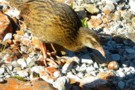
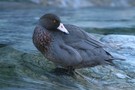
(Pihoihoi) - Pipit
Photograph
•
Distance: 1.8km away
Moaris used to mimick the pipits movements and use a tactic called Manukawhaki (decoy bird). They would pretend to retreat ...
More ▶︎
Newton Saddle
Photograph
•
Distance: 1.8km away
Newton Saddle between Dunns Creek (hut) and Newton Creek (hut), Westland
More ▶︎
Scottys Saddle Jan 2010
Photograph
•
Distance: 1.8km away
You can see this saddle from Scottys biv. It is about a 20 - 30 minute climb to the west.
More ▶︎
Picton to Aspiring
GPX file
•
Distance: 1.9km away
An aborted alpine traverse. Picton to West Cape, but aborted at Aspiring due to real world emergencies back home. Posted ...
More ▶︎
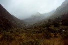
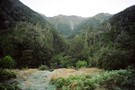
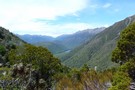
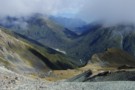
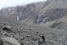
Descent to the Taipo Valley
Photograph
•
Distance: 2.0km away
Descent to the Taipo Valley from the Kelly Range, above Dillons Homestead / Hut
More ▶︎
Dunns Creek Hut
Photograph
•
Distance: 2.1km away
The marshes in the mid-reaches of Dunns Creek. Dunns Creek Hut is visi ble on the right: a wet spot!
More ▶︎
View from Dunns Creek Hut
Photograph
•
Distance: 2.1km away
View from Dunns Creek Hut, early evening in April.
More ▶︎
Mid Taipo Hut to Dunns Creek Hut
Track
•
Medium. Return by the same track.
•
Distance: 2.1km away
The more direct route from Mid Taipo to Dunns Creek, the alternative to heading all the way up Dunns Ck ...
More ▶︎
Dillons Hut (new)
Photograph
•
Distance: 2.2km away
Dillons Hut (new), Taipo Valley, Westland
More ▶︎
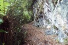
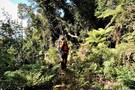
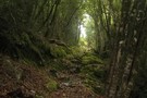
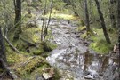
Cockayne Nature Walk
Track
•
Easy. Loop track.
•
Distance: 2.2km away
A short loop in forest near Kelly's Creek, Otira.
More ▶︎
Cockayne Nature Walk
GPX file
•
Distance: 2.2km away
Short walk in rich forest near Kellys Creek, Arthur's Pass National Park.
More ▶︎
Harman Pass - Taipo River - Kelly Saddle
Track
•
3 – 5 days. Medium/hard. One way.
•
Distance: 2.3km away
A long journey through the west of Arthur's Pass National Park.
More ▶︎
Ascent to Dunns Creek Hut
Photograph
•
Distance: 2.5km away
On reaching the waterfalls in Dunns Creek, this slip on the true left must be climbed for 100m or-so before ...
More ▶︎
Below Kelly-Hunt Saddle
Photograph
•
Distance: 3.1km away
The Kelly below the Kelly-Hunt Saddle
More ▶︎
Dunns Creek
Photograph
•
Distance: 3.3km away
The lower Dunns Creek ascending from the Taipo to Dunns Creek Hut
More ▶︎
Griffin Creek hut August 2010
Photograph
•
Distance: 3.4km away
Here is another pic of the hut but this one shows Razorback Ridge in the headwaters of Griffin Creek as ...
More ▶︎
Griffin Creek - Rocky Creek
Track
•
2 – 3 days. Medium. Return by the same track.
•
Distance: 3.4km away
An isolated circuit west of Arthur's Pass along lightly used tracks and rocky riverbeds that are home to blue ducks.
More ▶︎
Griffin Creek Hut
Hut
•
Basic Hut/Bivvy (DOC). Capacity: 5.
•
Distance: 3.4km away
A small but lovingly maintained DOC hut in an isolated valley that is home to a number of blue ducks. ...
More ▶︎

Griffin Creek Hut
Photograph
•
Distance: 3.4km away
This homely hut is well maintained but not often visited.
More ▶︎
Griffin Creek
GPX file
•
Distance: 3.5km away
The route in to Griffin Creek Hut from the highway.
More ▶︎
Newton Creek hut Dec 2011
Photograph
•
Distance: 3.7km away
This view of the hut looks SW. The hill in the background is Mt Newton which is on the opposite ...
More ▶︎
Newton Creek Hut
Hut
•
Basic Hut/Bivvy (DOC). Capacity: 4.
•
Distance: 3.7km away
Newton Creek Hut (4 bunk, mattresses, stove, firewood, water) is a pleasant forestry hut beside Newton creek. It's drier and ...
More ▶︎
Newton Creek Hut from Arahura Pack track
Article
•
Distance: 3.7km away
Formerly overgrown forest service track that could have led to underuse of lovely hut in magical setting.
More ▶︎
Hunts Creek
Photograph
•
Distance: 3.7km away
Barron Ridge is at left, and Hunts Ridge at right. Hunt Saddle is at bottom right and Kelly's Creek at ...
More ▶︎
Rocky Creek Biv
Photograph
•
Distance: 3.7km away
A little hut situated on a discreet terrace.
More ▶︎
Rocky Creek / Griffin Creek
Track
•
2 – 3 days. Medium. Loop track with a road section.
•
Distance: 3.7km away
2 day circuit in luxurious west coast bush with short above the bushline tussock section. 2 huts, Griffin Hut is ...
More ▶︎
Rocky Creek Bivvy
Hut
•
Basic Hut/Bivvy (DOC). Capacity: 2.
•
Distance: 3.7km away
Located on a small forested flat on Rocky Creek, north of the Tara Tama Range. This hut is very easily ...
More ▶︎
Griffin Creek Hut
Photograph
•
Distance: 3.7km away
Yes I am sure this is the track.. I think.....
More ▶︎
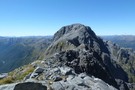
Faultline on Mt Olson May 2013
Photograph
•
Distance: 3.8km away
This picture shows a fault line on the eastern side of Mt Olson (1603m)
Mt Olson is a hill in ...
More ▶︎
Mid Taipo hut June 2009
Photograph
•
Distance: 4.2km away
An ex NZFS hut that was built in 1973. In the 70's it was known as "New Mid Taipo" because ...
More ▶︎
Mid Taipo hut
Hut
•
Standard Hut (DOC). Capacity: 6.
•
Distance: 4.2km away
An ex NZFS hut that was built in 1973. In the 70's it was known as "New Mid Taipo" because ...
More ▶︎
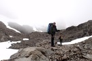
Descent from Kelly Tops to Hunts Saddle and Return!
Photograph
•
Distance: 4.3km away
Masochistic mission involving at times 40 degrees gradients where the techniques of hanging off scrub and sliding to the next ...
More ▶︎
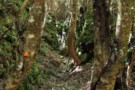
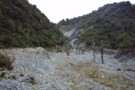
Track amongst gold workings Taipo River
Photograph
•
Distance: 4.6km away
This photo shows a section of the Seven Mile Creek to Kelly Range tops track that passes amongst old alluvial ...
More ▶︎

Griffin Tops
Photograph
•
Distance: 4.7km away
Looking along the tops toward Mt.Griffin.
The Serpentine mine is in view below the top of Mt.Griffin.
West of Arthurs Pass NP
More ▶︎
Goat Creek track to Mt Barron
Track
•
0 – 1 day. Hard. Loop track with a road section.
•
Distance: 4.8km away
Overgrown and line is destroyed by recent slips.
More ▶︎
McInerney tops
Photograph
•
Distance: 4.8km away
This photo shows from Rocky Saddle through to the northern end of the McInerney tops with the Hohonu Range beyond ...
More ▶︎
Griffin Range
Track
•
1 – 3 days. Medium. Return via same track.
•
Distance: 4.8km away
A traverse of undulating tops to the summit of Mount Griffin. Good camping next to pretty tarns, striking cliffs, and ...
More ▶︎
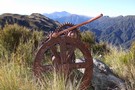
Relic from Griffin Range Serpentine Mine May 2010
Photograph
•
Distance: 4.8km away
This pic was taken at the old mine area where there are lots of relics. The perspective is looking NE ...
More ▶︎
Arahura River & swingbridge
Photograph
•
Distance: 4.9km away
The swingbridge over the Arahura on the track to Newton Creek Hut.
More ▶︎

Taipo River
Photograph
•
Distance: 4.9km away
Lower Taipo river valley from the Kelly Range above Dillons Hut
More ▶︎
Taipo River above Dillons Hut
Photograph
•
Distance: 4.9km away
Taipo River above Dillons Hut, Westland
More ▶︎
Dillons Hut
Hut
•
Standard Hut (DOC). Capacity: 10.
•
Distance: 4.9km away
The New Dillons Hut (sleeps 10, stove, tank water) lies in the middle reaches of the Taipo valley, 10 minutes ...
More ▶︎
Rangi-Taipo Traverse from Taipo Access 4WD track
Article
•
Distance: 4.9km away
10 hour untracked traverse though unpleasant nearly impenetrable vegetation culminating in glorious ascent to Rangi-Taipo and descent via overgrown but ...
More ▶︎
Head of Griffin Creek July 2011
Photograph
•
Distance: 5.1km away
This pic was taken a few minutes along the Griffin Range route from the turnoff from the Harrington Creek - ...
More ▶︎
Newton Creek Hut from Arahura Pack track
Track
•
1 day. Hard. One way.
•
Distance: 5.2km away
Former forest service track that was left to overgrow and suffered further damage from snow loading in winter of 2008.
Fortunately ...
More ▶︎

Dillon's Hut (historic)
Photograph
•
Distance: 5.2km away
Dillon's Hut (historic), in the Taipo Valley
More ▶︎
Dillons Hut (historic)
Photograph
•
Distance: 5.2km away
Dillons Hut (historic), in the Taipo Valley
More ▶︎
Dillon's Homestead (historic)
Hut
•
Standard Hut (DOC). Capacity: 5.
•
Distance: 5.2km away
Dillon's Homestead(historic) (5 beds, fireplace, tank & stream water, fiirewood available) is a well built, well restored hut in the ...
More ▶︎
Arahura-Styx track
Photograph
•
Distance: 5.4km away
The Arahura - Styx track: a benched historic pack-horse track through the Arahura and Styx valleys in Westland. An easy ...
More ▶︎
A closer view of the serpentine Mine
Photograph
•
Distance: 5.4km away
Perhaps a scar on the landscape but a point of interest all the same.
Griffin Tops is perhaps a place ...
More ▶︎
A tarn on Griffin Tops
Photograph
•
Distance: 5.4km away
On a shelf below Wilson's Knob 1291m, the southern side of Griffin Tops.
We didn't bring the Steripen so maybe ...
More ▶︎
Harper Pass - Kiwi Saddle
Track
•
5 – 7 days. Medium. One way.
•
Distance: 5.6km away
A classic crossing of the Main Divide, following the deep valleys of the Hope Fault from the Arthur's Pass road ...
More ▶︎
Otehake Hot Springs
Track
•
2 days. Easy/medium. Return via same track.
•
Distance: 5.6km away
A popular weekend route to good hot pools.
More ▶︎
Seven Mile hut Jan 2008
Photograph
•
Distance: 5.7km away
Well it is a surprise that this hut is still there. A while back I read that DOC had removed ...
More ▶︎
7 Mile Hut
Hut
•
Basic Hut/Bivvy (PVT). Capacity: 2.
•
Distance: 5.7km away
This hut is on private land and both have been bought by someone who has improved access to 7 Mile ...
More ▶︎
Mount Griffin (1516m)
Photograph
•
Distance: 5.8km away
The Alpine Fault passes along the northern foot of the Griffin Range, resulting in cliffs that reach up to the ...
More ▶︎
Tops route between Lower & Top Olderog bivs Jan 2010
Photograph
•
Distance: 6.0km away
This pic was taken from the summit of the McArthur Crags. The ridge running NE away from the viewers eye ...
More ▶︎
Top Olderog biv Jan 2010
Photograph
•
Distance: 6.0km away
This biv is located on the TR in the headwaters of the main branch of Olderog Creek. It is well ...
More ▶︎
Top Olderog biv
Hut
•
Basic Hut/Bivvy (DOC). Capacity: 2.
•
Distance: 6.0km away
This biv was built by the NZFS in 1971. It is located on the TR in the headwaters of the ...
More ▶︎
Negotiating treefall - Griffin Tops track
Photograph
•
Distance: 6.1km away
It's familiar, but climbing over on the return.
Took a way around on the ascent.
More ▶︎
Mount Barron Route
GPX file
•
Distance: 6.3km away
Old trail leading up the the tussock tops of Mount Barron. A good benched track leads up to a rocky ...
More ▶︎
Mount Barron tops
Photograph
•
Distance: 6.3km away
The end of the marked track up Mount Barron.
More ▶︎
Kelly Range from Hunts Creek Track
Photograph
•
Distance: 6.3km away
The route from the tops of the Kelly Range to Hunts Saddle drops through thick scrub to a small bog ...
More ▶︎
Barrack Creek Route
Photograph
•
Distance: 6.4km away
Goat Hill and Barrack Creek from Mount Barron. The route follows the spur to the true right of Barrack Creek.
More ▶︎
Mount Barron Route
Track
•
Medium/hard. One way.
•
Distance: 6.4km away
Old access track onto the Mount Barron tussock tops.
More ▶︎
Old Julia Hut
Photograph
•
Distance: 6.6km away
Old Julia Hut after refurbishment in February 2014.
More ▶︎
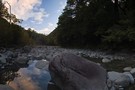
Taipo River, near Jacksons
Photograph
•
Distance: 6.6km away
Rocky Creek meets the Taipo River at this point, and you will too if you miss the track markers. Safer ...
More ▶︎
Kelly Tops, Dry Creek, Taipo Circuit
Article
•
Distance: 6.7km away
A 3 day circuit from 7 Mile Creek to the Kelly Tops, down to Hunts Saddle and then over Hunts ...
More ▶︎
Dry Creek
Photograph
•
Distance: 6.7km away
Dry Creek - descending into the Taipo from it's 1700m saddle off Hunts Creek
More ▶︎
Hunts Creek Hut
Hut
•
Standard Hut (DOC). Capacity: 4.
•
Distance: 6.8km away
A small hut handsomely located at the edge of a tussock clearing on Hunts Creek, west of Otira.
Hunts Creek takes ...
More ▶︎
Hunts Hut
Photograph
•
Distance: 6.8km away
A small but tidy hut located at the edge of a tussock clearing near Hunts Creek.
More ▶︎
Hunts Creek Hut
Photograph
•
Distance: 6.8km away
5-7 hours slog up Kellys Creek from the Otira highway, this little abode is welcome site after mud-jumping across Hunts ...
More ▶︎
Mudflats Hut
Hut
•
Standard Hut (DOC). Capacity: 6.
•
Distance: 7.1km away
Mudflats Hut (6 bunks, matresses, tank water, stove, firewood available) lies in the mid-reaches of the Arahura Valley in Westland. ...
More ▶︎
Mudflats Hut
Photograph
•
Distance: 7.1km away
Mudflats Hut, in the Arahura Valley, Westland.
More ▶︎
Arahura Valley
Photograph
•
Distance: 7.1km away
The Arahura Valley from the Mudflats swingbridge.
More ▶︎
Tarns on the tops above Camp Creek hut Sept 2010
Photograph
•
Distance: 7.1km away
These tarns are a short walk SW along the range from where the tops track emerges. Most people head along ...
More ▶︎
Taipo River track to Julia Hut
Photograph
•
Distance: 7.2km away
Taipo River track to Julia Hut - above Dry Creek
More ▶︎
Paratu Stream - Waharoa Saddle
Article
•
Distance: 7.2km away
The easiest route to Mt Pfeifer via an attractive bouldered stream and a magical saddle with flybys of kaka and ...
More ▶︎
Upper Hunts Creek
Photograph
•
Distance: 7.5km away
Upper Hunts Creek - valley head above the hut. Te pass to Dry Creek in the Taipo is up scree ...
More ▶︎
Mts Te Kinga & Alexander August 2011
Photograph
•
Distance: 7.7km away
This photo looks along the Te Kinga tops from the low peak near the trig to the top of Te ...
More ▶︎
Mt Alexander
Photograph
•
Distance: 7.7km away
Looking down on the confluence of the Otira and Taramakau rivers from Summit of Mt Alexander
More ▶︎
Mt Alexander
Photograph
•
Distance: 7.7km away
Looking back at point 1786 ,Mt Tekinga, Lake Brunner, Kangaroo Lake, Lady Lake and Swan lake
More ▶︎
Mount Alexander
Track
•
2 days. Medium. Return by the same track.
•
Distance: 7.7km away
A long climb to the summit of Mount Alexander (1958m) on the Kaimata Range. This range lies directly north of ...
More ▶︎
View from un-named Campbell Range saddle
Photograph
•
Distance: 7.8km away
This April 2013 photo was taken from the un-named Campbell Range Saddle at 1600m that is on the direct route ...
More ▶︎
Looking toward Mt Alexander from above Camp Creek hut Sept 2010
Photograph
•
Distance: 7.9km away
This picture was taken not far from where the tops track crests the ridge. Mt Alexander (1958m) is the back ...
More ▶︎
Mingha River-Deception River
Track
•
2 days. Medium. One way.
•
Distance: 8.3km away
Goat Pass Track. Alpine track over a pass between two river valleys.
More ▶︎
Track Descent
Photograph
•
Distance: 8.6km away
The map shows the track crossing two small tributaries before heading sharply down to meet the main river. You may ...
More ▶︎
The Track Starts
Photograph
•
Distance: 8.6km away
After three or four scree/shrub combinations, where the gorge below opens out a little, keep an eye out for the ...
More ▶︎
Grass my Arse
Photograph
•
Distance: 8.6km away
Sections of alpine "herbs" break up the scree slopes high above the Rolleston River. There is no track through these ...
More ▶︎
Pick Your Path
Photograph
•
Distance: 8.6km away
Try to stay reasonably high above the river on the true left for the easiest route down and to avoid ...
More ▶︎
Top of Rolleston Valley
Photograph
•
Distance: 8.6km away
There are sporadic cairns down into the Rolleston Valley, but they can be difficult to pick out against the scree. ...
More ▶︎
At the top
Photograph
•
Distance: 8.6km away
If intending to cross over into the Rolleston from the Waimak, DON'T go over the actual Waimak Col (you'll see ...
More ▶︎
Route Planning
Photograph
•
Distance: 8.6km away
Checking the map for a route over the head of the Waimakariri Valley into the Rolleston Valley. Be aware in ...
More ▶︎
Other Part of trail to Carrington Hut
Photograph
•
Distance: 8.6km away
the trail after a nice rain
More ▶︎
The Trail Klondyke Corner to Carrington Hu
Photograph
•
Distance: 8.6km away
view of the grassy trail before the riverbed becomes the trail.
The hut is still far here but it is behind ...
More ▶︎
Waimakariri River-Rolleston River
Track
•
2 – 3 days. Hard. One way.
•
Distance: 8.6km away
Alpine tramp over Waimakariri Col.
More ▶︎
Jade Prospectors hut at Olderog/Jade Ck confluence Feb 2009
Photograph
•
Distance: 8.6km away
This hut is known by the names of both the creeks it is at the confluence of. We used to ...
More ▶︎
Camp Creek hut Sept 2010
Photograph
•
Distance: 8.7km away
This hut is located 3kms up the Camp Creek access track to the Alexander/Kaimata Range tops. A sign at the ...
More ▶︎
Camp Creek hut
Hut
•
Standard Hut (DOC). Capacity: 9.
•
Distance: 8.7km away
This hut is located 3kms up the Camp Creek access track to the Alexander/Kaimata Range tops. A sign at the ...
More ▶︎
Mailbox at Camp Creek hut Sept 2010
Photograph
•
Distance: 8.7km away
Located on the side track just before the hut.
Doesn't look like the milkman has called for a while!
More ▶︎
Julia Hut
Hut
•
Standard Hut (DOC). Capacity: 6.
•
Distance: 8.7km away
Standard DOC hut at the confluence of Julia and Mary Creeks where they meet the Taipo River. Good hot pools ...
More ▶︎
Julia Hut
Photograph
•
Distance: 8.7km away
Standard DOC hut at the confluence of the Julia & Taipo rivers.
More ▶︎
SI Bush Robin in Old Julia hut April 2013
Photograph
•
Distance: 8.7km away
For the second time in about a month a bush robin has spent time in a hut that I've been ...
More ▶︎
inside old julia
Photograph
•
Distance: 8.7km away
a classic view of the interior of a classic hut. Note the hand hewn locally sourced timbers.
More ▶︎
"Old" Julia hut Feb 2009
Photograph
•
Distance: 8.7km away
Close to the "New" Julia hut near the confluence of Julia & Mary Creeks where they join to form the ...
More ▶︎
"Old" Julia hut
Hut
•
Basic Hut/Bivvy (DOC). Capacity: 4.
•
Distance: 8.7km away
Close to the "New" Julia hut near the confluence of Julia & Mary Creeks where they join to form the ...
More ▶︎

Descent from Pfeifer Biv into Pfeifer Creek via scree
Photograph
•
Distance: 8.8km away
Unmarked route exiting basin where biv lies, maintaining altitude to cross a spur after 20 minutes then travelling northeast along ...
More ▶︎
"Old" Pfeifer biv (Removed) Dec 2007
Photograph
•
Distance: 9.0km away
The old biv a few months before it was replaced.
More ▶︎
Pfeifer biv
Hut
•
Basic Hut/Bivvy (DOC). Capacity: 2.
•
Distance: 9.0km away
A new biv from early 2008 replacing an old biv that was about 20m to the south. (The sign on ...
More ▶︎
Pfeifer biv & toilet April 2012
Photograph
•
Distance: 9.0km away
A new biv from early 2008 replacing an old biv that was about 20m to the south. (The sign on ...
More ▶︎
Route down off McArthur Crags to Lower Olderog biv Jan 2010
Photograph
•
Distance: 9.0km away
This pic shows the SE leading spur off the top of Mt McArthur that leads down to Lower Olderog biv. ...
More ▶︎
Lower Olderog biv (aka Jade biv) Feb 2009
Photograph
•
Distance: 9.0km away
This biv is located on a bench well above the creek bed in the headwaters of Jade Creek. It is ...
More ▶︎
Lower Olderog biv (aka Jade biv)
Hut
•
Basic Hut/Bivvy (DOC). Capacity: 2.
•
Distance: 9.0km away
This NZFS biv dating from 1957 is located on a bench well above the creek bed in the headwaters of ...
More ▶︎
Pfeiffer Biv
Photograph
•
Distance: 9.1km away
cosy,dinky even,modern 2 bunker with longdrop nearby.
More ▶︎
birds-eye view
Photograph
•
Distance: 9.1km away
Looking from Waharoa Saddle down Pfeifer Stream & to Lake Kaurapataka
More ▶︎
Mt Kerr
Photograph
•
Distance: 9.3km away
Exploring the exposed tops above the Arahura RIver just before a front rolls in. Reached by an old NZFS track ...
More ▶︎
Upper Taipo towards Pope Pass
Photograph
•
Distance: 9.7km away
Upper Taipo towards Pope Pass - boulderfields through the last of the scrub-layer
More ▶︎
Posing on Mt Pfeifer
Photograph
•
Distance: 9.8km away
This pic looks westward from Mt Pfeifer during autumn conditions prior to the May snowfalls.
Mt Pfeifer is an easy ...
More ▶︎
traverse of Mt Pfeifer
Photograph
•
Distance: 9.9km away
Traverse of ridge south-east of the summit in clag. Getting around the boulder was tricky and a bit exposed.
More ▶︎
Looking down the Arahura River from near Campbell biv Feb 2009
Photograph
•
Distance: 9.9km away
This pic shows the Arahura River as far as the "big bend" where it goes out of sight then it ...
More ▶︎
Campbell biv Feb 2009
Photograph
•
Distance: 9.9km away
A 1950's vintage cullers biv located on a west facing spur of the Campbell Range. From the biv there are ...
More ▶︎
Campbell biv
Hut
•
Basic Hut/Bivvy (DOC). Capacity: 2.
•
Distance: 9.9km away
A 1950's vintage cullers biv located on a west facing spur of the Campbell Range. From the biv there are ...
More ▶︎