Nearby
Urquhart's Hut
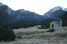
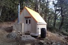
Weka Burnet biv
Hut
•
Basic Hut/Bivvy (DOC). Capacity: 2.
•
Distance: 2.7km away
2 person upright biv as opposed to the dogbox style at junction of Weka and Burnet Streams, not far from ...
More ▶︎
Unknown Stream Hut
Hut
•
Standard Hut (DOC). Capacity: 4.
•
Distance: 5.0km away
Located on the true left of Unknown Stream off the Wilberforce River.
More ▶︎

Arthur's Pass National Park
Place
•
National Park. 1145.00km2.
•
Distance: 6.1km away
This alpine park straddles the Main Divide of the Southern Alps, with dry beech forests in the east and damp ...
More ▶︎
4 day circuit in Arthurs Pass - White Col, Weka Burnet, Bristed Stream, Jordan Saddle
Article
•
Distance: 6.8km away
1st day: Barker Hut, 2nd day: Weka Burnet Biv via White Col and Burnet Stream, 3rd day: Bristed Stream to ...
More ▶︎
Craigieburn Forest Park
Place
•
Conservation Park. 441.65km2.
•
Distance: 7.1km away
A small park south of Arthur's Pass National Park including a series of ski fields. Highest point: 2141m (Mt Avoca).
More ▶︎
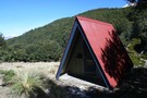
Park Morpeth Hut
Hut
•
Standard Hut (DOC). Capacity: 6.
•
Distance: 7.2km away
This is a Canterbury Mountaineering Club Hut, and it appears in DOC's hut list. On the classic Three Passes route.
More ▶︎
Barker Hut
Track
•
2 – 3 days. Medium. Return by the same track.
•
Distance: 8.1km away
Surrounded by glaciers at the head of the White River, this is the highest hut in Arthur's Pass National Park.
More ▶︎
Barker Hut
Hut
•
Serviced Alpine Hut (Canterbury Mountaineering Club). Capacity: 10.
•
Distance: 8.1km away
At 1560m, Neville Barker Memorial Hut is the highest in Arthur's Pass National Park, surrounded by the glaciers of the ...
More ▶︎
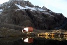
Looking down on Barker Hut
Photograph
•
Distance: 8.1km away
On a perfect autumn morning we picked our way up some of the ridges of shattered rock behind Barker Hut. ...
More ▶︎
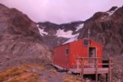
Barker Hut
Photograph
•
Distance: 8.1km away
The Barker Hut on an absolutely stunning April morning in 2011. Not a breath of wind, not a cloud in ...
More ▶︎
Barker Hut at sunrise.
Photograph
•
Distance: 8.3km away
Overcast March morning after a night of wind and sleet.
More ▶︎
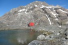
Barker Hut
Photograph
•
Distance: 8.3km away
The Canterbury Mountaineering Club hut high at the head of the White River.
More ▶︎
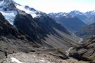
White River
Photograph
•
Distance: 9.0km away
Barker Hut sits on the rocky outcrop at centre.
More ▶︎
Browning Pass zig-zag
Photograph
•
Distance: 9.1km away
The zig-zag trail going up to Browning Pass on the 3 passes route. taken February 2007
More ▶︎
Kokatahi River
Photograph
•
Distance: 9.4km away
Kokatahi River, between Crawford Junction Hut and Top Kokatahi Hut.
More ▶︎
Avoca Hut
Hut
•
Basic Hut/Bivvy (Canterbury University tramping Club). Capacity: 6.
•
Distance: 9.5km away
Small hut in the Avoca Valley.
Open to public, maintained by Canterbury University tramping Club (CUTC). Report any damage to CUTC ...
More ▶︎
Three Passes
Track
•
4 – 5 days. Medium/hard. One way.
•
Distance: 9.6km away
A classic trip from Arthur's Pass across Browning, Whitehorn and Harman Passes, emerging near Lake Kaniere on the West Coast.
More ▶︎
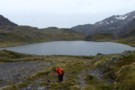
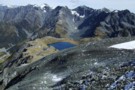
Lake Browning
Photograph
•
Distance: 9.6km away
Lake Browning, behind Browning Pass. Officially the West Coast after crossing Browning Pass, now the rain starts.
More ▶︎
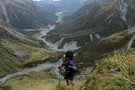
Climbing Browning Pass
Photograph
•
Distance: 9.6km away
Ascending the zig-zag tracked part of Browning Pass. It's a steep scramble up the scree at the top, probably better ...
More ▶︎
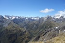
Browning Pass etc from Mt Browning Nov 2017
Photograph
•
Distance: 9.6km away
Looking toward Browning Pass etc from high on Mt Browning.
I climbed up from the Styx Saddle and enjoyed great ...
More ▶︎
Mungo hut Feb 2012
Photograph
•
Distance: 9.8km away
The Mungo is a tributary of the Hokitika River. The hut is situated on a terrace between the Mungo River ...
More ▶︎
Mungo hut
Hut
•
Basic Hut/Bivvy (DOC). Capacity: 4.
•
Distance: 9.8km away
The Mungo is a tributary of the Hokitika River. The hut is situated on a terrace between the Mungo River ...
More ▶︎

Mungo River and Brunswick Creek April 2011
Photograph
•
Distance: 9.9km away
This pic shows part of the Mungo River and its tributary Brunswick Creek. It was taken from near the true ...
More ▶︎
Mungo Valley & Park Stream April 2011
Photograph
•
Distance: 9.9km away
This pic looks up the Mungo River. On the left (TR) you can see tributaries Saddle Creek & Park Stream. ...
More ▶︎
Tops SW of Lake Browning April 2013
Photograph
•
Distance: 9.9km away
I'm sharing this photo of the area near Browning Pass. I guess it must be one of my favoured areas ...
More ▶︎