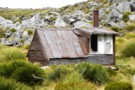
Nearby
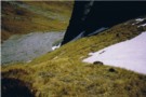
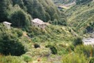
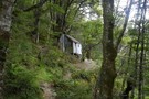
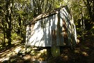
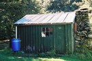
Shelter Rock Hut
Shelter Rock Hut
Photograph
•
Distance: less than 100m away
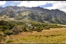
Shelter Rock Hut in its surrounding mountains
More ▶︎
Matukituki to Paradise by roads less travelled
GPX file
•
Distance: less than 100m away
A rough, tough crossing from Raspberry Flat (Aspiring Road, Wanaka) to the Earnslaw Burn (Glenorchy-Paradise road) via Shotover Saddle, Lochnagar, ...
More ▶︎
Rees-Dart Track
Track
•
3 – 4 days. Medium/hard. Loop track.
•
Distance: less than 100m away
Alpine circuit along two river valleys at the head of Lake Wakatipu.
More ▶︎

Haast to The Divide
GPX file
•
Distance: less than 100m away
Andrew Barker's traverse 2009. From Pleasant Flat in the Haast to The Divide via Mt Aspiring National Park.
More ▶︎
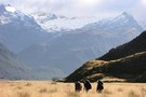
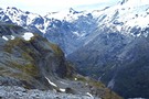
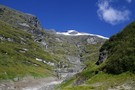
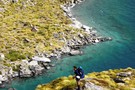
Rees Vally
Photograph
•
Distance: 1.6km away
A photo taken looking towards the rees saddle, taken inbetween rees saddle and shelter rock hut
More ▶︎
rees valley
Track
•
3 days. Medium. Return via same track.
•
Distance: 4.3km away
pleasant walk up the rees valley. the track gets a bit swampy at the start and then a few avalance ...
More ▶︎
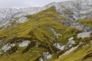
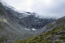
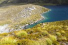
Rees Saddle
Photograph
•
Distance: 4.5km away
This picture was take at the top of the rees saddle looking down towards the rees vally in december 2006
More ▶︎
Rees Saddle from near Cleft Peak
Photograph
•
Distance: 4.5km away
Rees Saddle from near Cleft Peak; Snowy Creek to the right, & the Rees to the left.
More ▶︎
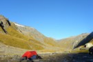
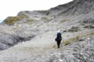
The sun is always brighter on the other side
Photograph
•
Distance: 5.2km away
That's the last we'll see of the sun tonight. The Rees valley continues to be flooded with rays.
Rees Saddle from ...
More ▶︎
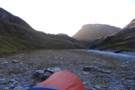
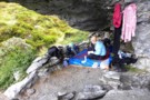
Overnight beside Snowy Ck. - Mt.Aspiring NP NZ
Photograph
•
Distance: 5.2km away
Looking upstream on Snowy Ck. after crossing Rees saddle. Around the corner is a broad spur giving access to a ...
More ▶︎
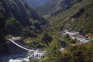
Dart Hut
Photograph
•
Distance: 5.5km away
Dart hut, taken from the swing bridge crossing the Snowy stream, just as you approach the hut
More ▶︎
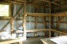
Cattle Flat Biv
Photograph
•
Distance: 5.6km away
Plenty of room for everyone to get out of the rain and enjoy a brew
More ▶︎
Cattle Flat Bivy Rock
Hut
•
Natural shelter (NA).
•
Distance: 5.6km away
A huge shelter rock in the Dart half way between Dart & Daleys Huts. It is back in the bush ...
More ▶︎
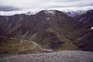
Rees valley
Photograph
•
Distance: 8.0km away
Looking up the Rees valley from near 25-mile spur (April 2009)
More ▶︎
The spur between Snowy Ck and Pine Ck basin - Lochnagar route
Photograph
•
Distance: 8.5km away
The book at Tummel Burn hut in the upper Shotover would have you believe nine out of ten people descend ...
More ▶︎
Earnslaw Hut
Photograph
•
Distance: 8.5km away
Rough four-bunk historic hut below Kea Basin on the ascent to Mt Earnslaw
More ▶︎
Earnslaw Hut
Hut
•
Basic Hut/Bivvy (DOC). Capacity: 4.
•
Distance: 8.5km away
Earnslaw hut. Located near Kea Basin on the slopes of Mt Earnslaw, above the Rees valley.
More ▶︎
Looking inside Earnslaw Hut - Mt.Aspiring NP
Photograph
•
Distance: 8.6km away
An old hut with a distinctive rustic look. I believe many people would prefer to occupy the rock bivvy at ...
More ▶︎
Earnslaw Hut - Mt.Earnslaw - Mt.Aspiring NP
Photograph
•
Distance: 8.6km away
At appx 980m set in beech forest above the Rees valley. This historic hut is on a short 50m side ...
More ▶︎
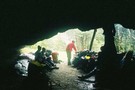
Kea Basin Bivvy - Mt.Earnslaw
Photograph
•
Distance: 8.6km away
This is one of the best bivvy rocks i've seen. Situated at appx 1060m on the north flank of Mt.Earnslaw. ...
More ▶︎
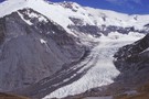
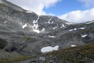
Joe Glacier
Photograph
•
Distance: 9.0km away
A view of the head of the Joe river and the remains of the Joe glacier in Aspiring National Park. ...
More ▶︎
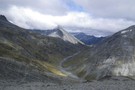
Snowy Creek
Photograph
•
Distance: 9.2km away
Snowy Creek - viewed from saddle 1950 on the way over from Lochnagar Hut
More ▶︎
The upper basin of Pine Creek. Mt.Aspiring NP NZ
Photograph
•
Distance: 9.2km away
After crossing over the pass from Snowy Ck, it was thought we'd get a break from the wind. Fortunately we ...
More ▶︎
Pine Creek
Photograph
•
Distance: 9.4km away
Upper basin of Pine Creek, crossing to Snowy from Lochnagar
More ▶︎
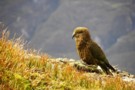
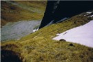
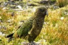
The mind of a mischief at work
Photograph
•
Distance: 9.6km away
Kea show their usual boundless curiosity in Pine Ck basin.
More ▶︎
Lennox Creek, South Branch
Photograph
•
Distance: 9.6km away
Upper crossing of Lennox Creek (south branch). Not a place to be with unstable snow above.
The next viable crossing is ...
More ▶︎
25-Mile Hut
Photograph
•
Distance: 9.6km away
This is a derelict Hut on the Rees Dart track. It is in an ideal location on a terrace above ...
More ▶︎
25 Mile Hut
Hut
•
Removed!
•
Distance: 9.6km away
*EDIT* From DOCs website:
28 April 2016: Rees Valley - 25 Mile Hut removed
The derelict 25 Mile Hut in the Rees ...
More ▶︎
Dart/Lochnagar
Track
•
1 – 2 days. Hard. One way.
•
Distance: 9.6km away
10 hour trip from Dart Hut to Lochnagar via Snowy Saddle
More ▶︎
Have we met?
Photograph
•
Distance: 9.6km away
This may well be the same group that visit us on Shotover Saddle the night after next. The ones who ...
More ▶︎
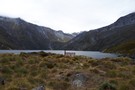
Lochnagar Hut
Hut
•
Private hut (PVT). Capacity: 4.Bookings required.
•
Distance: 9.7km away
Old style musterers hut yet rebuilt in 1990. Painted corrugated iron half buried in earth with a partial schist slabbed ...
More ▶︎
Lochnagar Hut
Photograph
•
Distance: 9.8km away
A hut was built here at Lochnagar in 1982. It was burnt down in 1988. As part of the 150th ...
More ▶︎
Descending to Lochnagar Hut
Photograph
•
Distance: 9.8km away
Standing above the lake to its north. Showing the outlet which becomes sub-terranian. This spur leads down from Pt.1865 which ...
More ▶︎
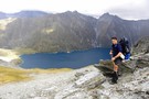
A meeting with the water.
Photograph
•
Distance: 9.8km away
Providing a different perspective to show the scale of things. Still a couple of hundred metres above the lake. Lochnagar ...
More ▶︎
Standing above Lochnagar (Goat Lake) - Mt.Aspiring NP
Photograph
•
Distance: 9.9km away
No snow in March 2010 on the south facing slopes to the north of Lochnagar. Taken from the col between ...
More ▶︎