Nearby
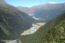
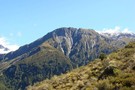
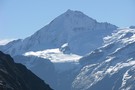
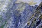
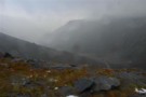
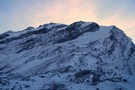
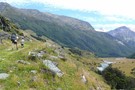
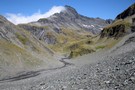
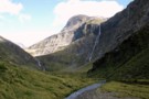
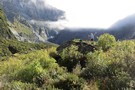
Looking south from Sysiphus Peak
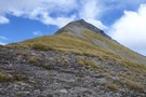
Sisyphus Peak from Wilmot Saddle
Photograph
•
Distance: less than 100m away
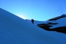
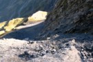
Still 200m to go.
Sisyphus Peak (1859m) from Wilmot Saddle (1682m).
More ▶︎
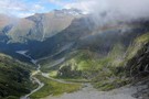
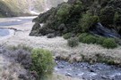
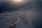
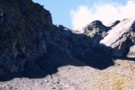
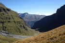
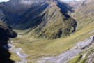
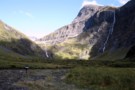
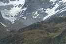
Aspiring Flat and Sisyphus Peak
Track
•
3 days. Medium. Return via same track.
•
Distance: less than 100m away
A one and two-half day tramp up the East Matukituki to overnight in Aspiring Flats, with a day trip up ...
More ▶︎
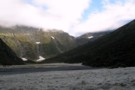
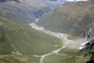
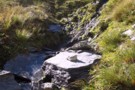
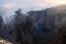
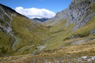
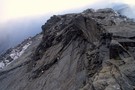
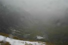
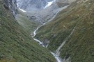
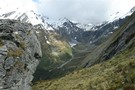
Rainbow Stream
Photograph
•
Distance: less than 100m away
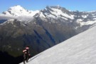
Probably at about 1000m here, 500m above Aspiring Flats visible below.
We faffed around somewhere near here and lost a couple ...
More ▶︎
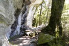
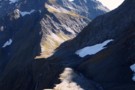
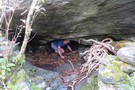
Rock of Ages Bivouac
Rock bivouac
•
Distance: 357m away
An overhang above the Kitchener River and Aspiring Flats, near the Matukituki East Branch. Room to sleep 10, although exposed ...
More ▶︎
Picton to Aspiring
GPX file
•
Distance: 387m away
An aborted alpine traverse. Picton to West Cape, but aborted at Aspiring due to real world emergencies back home. Posted ...
More ▶︎
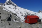
Rock of Ages bivvy - Mt.Aspiring Flats
Photograph
•
Distance: 526m away
A short distance from the East Matukituki, through which flows Kitchener stream is Aspiring Flats. Coveniently located is a rock ...
More ▶︎

Haast to The Divide
GPX file
•
Distance: 680m away
Andrew Barker's traverse 2009. From Pleasant Flat in the Haast to The Divide via Mt Aspiring National Park.
More ▶︎
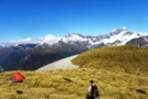
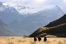
A camp with a view over the East Matukituki
Photograph
•
Distance: 3.7km away
Kathryn returns from Dragonfly Peak to her camp on the ridge to South AlbertBurn saddle from the East Matukituki.
More ▶︎
A visit to South AlbertBurn saddle
Photograph
•
Distance: 4.3km away
Michael crosses the snow slopes above Hester Pinney Creek. The sun has only just risen over the saddle and the ...
More ▶︎
Approaching the South AlbertBurn saddle and the sun
Photograph
•
Distance: 4.5km away
An early start made it easier to cross the slopes above Hester Pinney Ck. We were pleased to make it ...
More ▶︎
North Ruth Flat Rock Bivvy
Rock bivouac
•
Distance: 5.2km away
Good rock bivvy formed by an overhanging rock cliff located north of Ruth Flat in the East Matukituki. On topo ...
More ▶︎
Rabbit Pass - Wilkin to East Matukituki
Track
•
1 day. Hard. One way.
•
Distance: 5.3km away
A fair weather route linking the upper Wilkin valley to the head of the East Matukituki. Two dangerous climbs are ...
More ▶︎
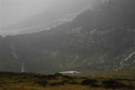
Frosty Morning in the East Matukituki
Photograph
•
Distance: 5.3km away
Taken from near the rock biv at the top of Ruth Flats looking North towards Rabbit Pass in the clouds.
More ▶︎
Ruth Flat Bivy
Photograph
•
Distance: 5.3km away
Found at the North End of Ruth Flat this bivy provides easy accomodation for those not wanting to carry on ...
More ▶︎
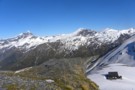
Dragonfly slopes
Photograph
•
Distance: 5.3km away
From a short distance above South AlbertBurn saddle. Whare-Kea Lodge can be seen below in the saddle. Note: The saddle ...
More ▶︎
Olivine Wilderness Area
Place
•
Wilderness Area. 830.00km2.
•
Distance: 5.8km away
Remote country in the Olivine Range. The wilderness area includes the Red Hills, the Olivine Ice Plateau, and the Joe ...
More ▶︎
French Ridge
Track
•
2 – 4 days. Medium. Return via same track.
•
Distance: 5.9km away
A steep climb to the snowline in the West Matukituki.
More ▶︎
Aspiring - Rees
GPX file
•
Distance: 6.0km away
Starting at Raspberry Flat, this track passes Mt Aspiring Hut in the West Matukituki Valley and then climbs steeply to ...
More ▶︎
Rabbit Pass is up there
Photograph
•
Distance: 6.0km away
View from the East Branch Matukituki River of the descent from Rabbit Pass
More ▶︎
Matukituki to Paradise by roads less travelled
GPX file
•
Distance: 6.0km away
A rough, tough crossing from Raspberry Flat (Aspiring Road, Wanaka) to the Earnslaw Burn (Glenorchy-Paradise road) via Shotover Saddle, Lochnagar, ...
More ▶︎
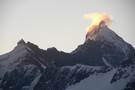
Is Aspiring erupting?
Photograph
•
Distance: 6.0km away
The sunset behind Mt.Aspiring provides some interesting effect.
More ▶︎

Mount Aspiring National Park
Place
•
National Park. 3555.18km2.
•
Distance: 6.4km away
The third-largest national park, although most of its space is under-utilised. The Routeburn is the second busiest trail in New ...
More ▶︎
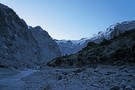
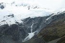
The Quarterdeck Glacier
Photograph
•
Distance: 7.1km away
Taken from the last rock outcrop at the base of the glacier at around about the 1860m mark, Mt French ...
More ▶︎
The East Matukituki from Rabbit Pass - a video
Video
•
Distance: 7.3km away
Shot on my point and shoot digital camera, hopefully gives some idea of the amazing view from this spot!
More ▶︎
The East Matukituki from Rabbit Pass
Photograph
•
Distance: 7.3km away
From just past the pass looking South over the valley from some 600 metres above the valley floor.
More ▶︎
Birthplace of Rivers
Photograph
•
Distance: 7.3km away
From such humble beginnings does the South branch of the Wilkin start.
More ▶︎
Rabbit Pass
Photograph
•
Distance: 7.4km away
A view of Rabbit Pass from just below the drop off point. In the distant is the route from Waterfall ...
More ▶︎
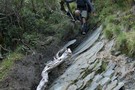
East Matukituki Cliff Route
Photograph
•
Distance: 7.5km away
Not a good picture of the route, but the best I have! The descent down starts in the sunny bit ...
More ▶︎
Gloomy Gorge
Photograph
•
Distance: 7.6km away
An 800 odd metre drop off seperates French Ridge from Gloomy Gorges floor.
More ▶︎
Rabbit Pass from under Lois Peak
Photograph
•
Distance: 7.7km away
Looking West along the cliff top towards Rabbit Pass, Pickelhaube and the Beauty Ridge above, the East Matukituki waterfall below.
More ▶︎
East Branch Matukituki visible through the rain
Photograph
•
Distance: 7.7km away
Demon descent in the conditions
More ▶︎
Descent of the Matukituki Cliff
Photograph
•
Distance: 7.7km away
Taken from the top of the cliff the route zigzags steeply down on the left of frame for about 20m ...
More ▶︎
Rabbit Pass from Pearson Saddle
Photograph
•
Distance: 7.8km away
Looking from a great spot for lunch on the saddle towards the pass.
More ▶︎
View from Pearson Saddle
Photograph
•
Distance: 7.8km away
Looking West into the Pearson River valley with a distant glimpse of the Waiatoto valley.
More ▶︎
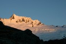
Mt French
Photograph
•
Distance: 7.8km away
Dawn reveals an overnight dusting of snow covers Mt French and the Quarterdeck glacier.
More ▶︎
Rock Formations on French Ridge
Photograph
•
Distance: 7.9km away
Interesting formations on the way up the ridge to the Quarterdeck glacier.
More ▶︎
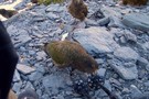
Mmmmmm tasty
Photograph
•
Distance: 8.0km away
While stopping for a rest on the way back down to the hut a flock of thirteen Keas drop in ...
More ▶︎
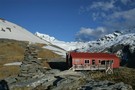
French Ridge Hut
Photograph
•
Distance: 8.5km away
This NZAC hut is located on the summer snowline near Mount Aspiring.
More ▶︎
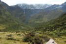
West Matukituki valley
Photograph
•
Distance: 8.7km away
Looking up the West Matukituki valley
More ▶︎
Colin Todd Hut
Photograph
•
Distance: 8.7km away
Perched on the side of Mt Aspiring above the Bonar Glacier, Colin Todd Hut serves as a base for climbers. ...
More ▶︎
Waterfall Flat from above
Photograph
•
Distance: 8.8km away
Scungy weather continues to obscure the views, topped by a raging wind....
More ▶︎
Waterfall Face, Wilkin River
Photograph
•
Distance: 8.8km away
Misty rain obscures the infamous Waterfall Face
More ▶︎
Upper Wilkin South Branch
Photograph
•
Distance: 8.9km away
Taken from above the Waterfall Face looking South West towards Pickelhaube. Pearson Saddle is the low grassy bit beneath Pickelhaube ...
More ▶︎
Waterfall Flat from ontop of the Waterfall Face
Photograph
•
Distance: 8.9km away
Having made it to the top you are gifted views such as this.
More ▶︎
Closeup of the Wilkin Waterfall Route
Photograph
•
Distance: 9.0km away
Hard to get a good angle of this! The route initially goes up the middle of the 2nd to the ...
More ▶︎
The Wilkin Waterfall Face
Photograph
•
Distance: 9.0km away
The route to Rabbit Pass climbs up the cliff to the right of the falls.
More ▶︎
Waterfall Flat
Photograph
•
Distance: 9.0km away
Looking over the South branch of the Wilkin towards the Wilkin Waterfall Face and Mt Taurus.
More ▶︎
Gloomy Gorge
Photograph
•
Distance: 9.1km away
Viewed from the French Ridge Track, with Mount Avalanche in the background.
More ▶︎
Mount Avalanche avalanche
Photograph
•
Distance: 9.1km away
Viewed from the French Ridge Track. Avalanches from here, from Rob Roy Peak, or from peaks across the valley can ...
More ▶︎
Tramping in the Wilkin Waterfall valley
Photograph
•
Distance: 9.1km away
Approaching the dreaded 200m Wilkin Waterfall face, we're dwarfed by the 400m waterfall tumbling off the North slopes of Mt ...
More ▶︎
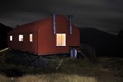
French Ridge Hut at night
Photograph
•
Distance: 9.1km away
210 second exposure @ f / 4.0, 17mm
More ▶︎
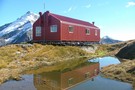
French Ridge Hut Reflection
Photograph
•
Distance: 9.1km away
Reflection of the French Ridge Hut in the tarn on a fine April day.
More ▶︎
French Ridge Hut
Hut
•
Serviced Alpine Hut (NZAC). Capacity: 20.
•
Distance: 9.1km away
This new hut is located on the summer snowline on French Ridge, near the head of the Matukituki Valley West ...
More ▶︎
Head of the Matukituki Valley West Branch
Photograph
•
Distance: 9.2km away
Viewed from French Ridge Track.
More ▶︎
Liverpool Hut
Photograph
•
Distance: 9.2km away
Viewed from the French Ridge Track across the valley
More ▶︎
Scotts Rock Biv
Rock bivouac
•
Distance: 9.3km away
Located at the head of the Matukituki River West Branch, beyond Pearl Flat.
The biv is 500m upstream of the upper ...
More ▶︎
Pearl Flat to Scott's Bivvy
GPX file
•
Distance: 9.3km away
A new track has been cut through bush up the true left of the Matukituki river from Pearl Flat to ...
More ▶︎
Scotts Bivvy
Hut
•
Natural shelter (NA). Capacity: 2.
•
Distance: 9.3km away
A poor shelter for two people. Beware of the resident stream within the bivvy when it rains
More ▶︎
Scotts Bivvy
Photograph
•
Distance: 9.3km away
Standing on top of the Bivvy. The head of the valley beyond
More ▶︎
Colin Todd Hut
Hut
•
Serviced Alpine Hut (NZAC). Capacity: 12.
•
Distance: 9.5km away
This 1996 hut replaced the original, constructed in 1960. It was named after one of the best-known Post-War New Zealand ...
More ▶︎
Route from Pine Creek to Matukituki Valley via Shotover Saddle
GPX file
•
Distance: 9.5km away
(Partial) route from Pine Creek to Matukituki via Shotover Saddle. The cattle track passage in this file is probably very ...
More ▶︎
French Ridge Track
Photograph
•
Distance: 9.7km away
The French Ridge Track features tangled roots, steep gradients, and clambering down rock walls.
More ▶︎