Nearby
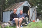
Dog Kennel Hut
Dog Kennel Bivvy
Hut
•
Basic Hut/Bivvy (DOC).
•
Distance: 143m away
Basic hut, no bunks, dirt floor, but still good shelter. Fireplace outside.
More ▶︎
Te Kahui Kaupeka Conservation Park
Place
•
Conservation Park. 938.00km2.
•
Distance: 2.2km away
Canterbury high country park including the Two Thumb Range and large portions of Mesopotamia Station.
More ▶︎
Ayres Hut (Removed)
Hut
•
Removed!
•
Distance: 2.5km away
Restored 4 bunk hut one hour up Black Birch Stream, Mesopotamia, in Two Thumb Range. As of 2012, DOC reports ...
More ▶︎
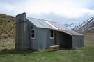
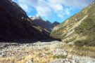
Crooked Spur Hut
Hut
•
Basic Hut/Bivvy (DOC). Capacity: 8.
•
Distance: 4.7km away
A beech-pole hut constructed 1947, and located about 1 hour's climb above the streambed of Bush Stream near Mesopotamia. Used ...
More ▶︎
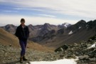
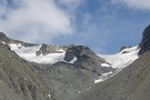
Alma Col
Photograph
•
Distance: 7.3km away
Technically easy but long pass between Rangitata and Macauley watersheds.
More ▶︎
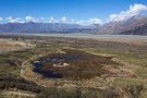
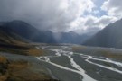
Mount Sunday Wetland
Photograph
•
Distance: 7.7km away
Fenced wetland on the Rangitata Riverbed, managed by Environment Canterbury. The wetland was fenced early 2013, and already in just ...
More ▶︎
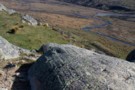
Glacial scratches on the summit of Mount Sunday
Photograph
•
Distance: 7.7km away
Mount Sunday was once underneath the Rangitata Glacier, and these scratches remain from rocks being dragged over the summit.
More ▶︎
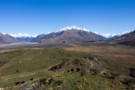
Havelock and Clyde Rivers from Mount Sunday
Photograph
•
Distance: 7.7km away
To the right is Newton Peak (2543m) between the Garden of Eden and Garden of Allah Ice Plateaux, and overlooking ...
More ▶︎
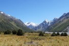
Mount Sunday, Rangitata River
Track
•
Easy. Return by the same track.
•
Distance: 7.7km away
Short walk to a roche moutonnée, a rocky outcrop in the Rangitata River channel. The hill was used as the ...
More ▶︎
The Havelock
Article
•
Distance: 7.9km away
The Havelock River is one of the six great Canterbury rivers. As shown in Mathew's photo above, the peaks rise ...
More ▶︎
Havelock Valley
Photograph
•
Distance: 8.2km away
Havelock Valley, from just below The Growler (creek). The private Growler Hut is on the flats on the left beyond ...
More ▶︎
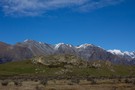
Mount Sunday
Photograph
•
Distance: 8.4km away
Little Mount Sunday (611m) is a roche moutonnée in the Rangitata Riverbed. Behind is the Black Mountain Range.
More ▶︎
Whitcombe Pass & Butler Saddle
Article
•
Distance: 8.9km away
route guide attached by for Hokitika Gorge to Erewhon via Whitcombe Pass & Butler Saddle. The guide was written by ...
More ▶︎

Te Araroa Trail
Track
•
95 days. Medium. One way.
•
Distance: 8.9km away
Te Araroa is a walking trail running the entire length of the North and South Islands. The trail opened 3 ...
More ▶︎
Erewhon Station - Garden Of Eden - Perth River - Whataroa
Track
•
5 – 7 days. Hard. One way.
•
Distance: 9.4km away
Erewhon Station, McCoy Hut, Wee MacGregor Glacier, Garden Of Eden, Adverse Creek, Perth River, Whataroa
More ▶︎
The Growler (creek)
Photograph
•
Distance: 9.7km away
The Growler (creek), from the confluence with the Havelock, near Growler Hut.
More ▶︎
Picton to Aspiring
GPX file
•
Distance: 9.9km away
An aborted alpine traverse. Picton to West Cape, but aborted at Aspiring due to real world emergencies back home. Posted ...
More ▶︎
Mount Potts Station campsite
Campsite
•
Standard Campsite (Private).
•
Distance: 9.9km away
Powered and tent sites located on Mount Potts Station. The lodge also offers other accommodation, and a café/restaurant and bar.
Nearby ...
More ▶︎