Nearby
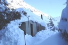
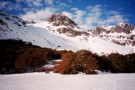
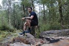
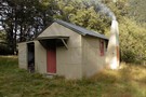
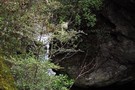
Travers Falls
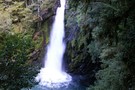
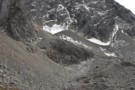
Travers Waterfall
Photograph
•
Distance: less than 100m away
a 15m fall - just a few minutes off the main Travers track (sign-posted) - Apr 2011
More ▶︎
St Arnaud to Lewis Pass
Track
•
5 – 9 days. Medium/hard. One way.
•
Distance: 1.5km away
A 5-9 day north-south route from St Arnaud to the Lewis Pass, via Travers Pass, Waiau Pass, Thompson Pass and ...
More ▶︎
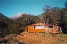
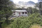
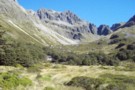
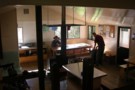
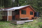
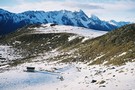
John Tait Hut
Hut
•
Serviced Hut (DOC). Capacity: 30.
•
Distance: 1.6km away
A good hut situated 5 hours easy walk from the head of Lake Rotoiti. Good views of Mt. Travers up ...
More ▶︎

Route Guide: St Arnaud to Lewis Pass
Article
•
Distance: 1.6km away
A 5-7 day north-south route from St Arnaud to the Lewis Pass, via Travers Pass, Waiau Pass, Thompson Pass and ...
More ▶︎
John Tait Hut
Photograph
•
Distance: 1.6km away
April 2010 - there is a large area of avalanche debris to the immediate right of this photo (out of ...
More ▶︎

Lake Thompson
Photograph
•
Distance: 1.6km away
A view of the beautiful Lake Thompson, a short distance from Thompson Pass
More ▶︎
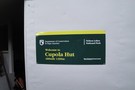
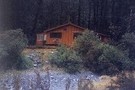
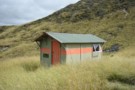
Cupola Basin Hut
Photograph
•
Distance: 3.1km away
Walked in from St. Arnaud and stayed overnight April 2002, as part of the popular Travers/Sabine circuit. I must have ...
More ▶︎
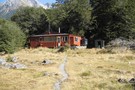
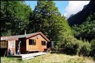
Cupola basin Hut
Hut
•
Standard Hut (DOC). Capacity: 8.
•
Distance: 3.1km away
A hut on the bushline with great views, well worth the up-hill grunt to get there.Even more spectacular when visited ...
More ▶︎
Cupola basin Hut
Photograph
•
Distance: 3.1km away
A snow covered Cupola Basin Hut visited on 6th and 7th July 2008.Stunning views of the surrounding mountains make the ...
More ▶︎
Picton to Aspiring
GPX file
•
Distance: 3.6km away
An aborted alpine traverse. Picton to West Cape, but aborted at Aspiring due to real world emergencies back home. Posted ...
More ▶︎
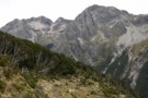
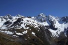
Mt Travers
Photograph
•
Distance: 3.7km away
Mt Travers from Upper Travers Hut - 2338m - Apr 2011
More ▶︎
Upper Travers Hut
Hut
•
Serviced Hut (DOC). Capacity: 24.
•
Distance: 3.7km away
The original hut has been replaced by a larger hut. The new hut is in the shelter of the trees ...
More ▶︎
Upper Travers Basin
Photograph
•
Distance: 3.7km away
The pot belly stove in the new hut at Upper Travers got a strong workout in the winter of 2004. ...
More ▶︎
Upper Travers Hut
Photograph
•
Distance: 3.9km away
Upper Travers Hut with Travers Pass beyond, Nelson Lakes
More ▶︎
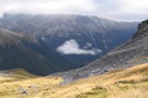
Travers Pass
Photograph
•
Distance: 4.2km away
beginning of the climb to Travers Pass, looking down the Travers Valley - Apr 2011
More ▶︎
Travers Pass
Photograph
•
Distance: 4.5km away
final ascent to Travers Pass - Mt Travers in the background - Apr 2011
More ▶︎
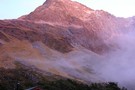
Mt Franklin
Photograph
•
Distance: 4.6km away
taken on the descent from Travers Pass into the E Sabine River - Apr 2011
More ▶︎
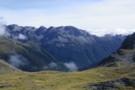
Travers-Sabine Saddle
Photograph
•
Distance: 4.6km away
Going over the saddle looking west towards the Sabine Valley - April 2010.
More ▶︎
Travers-Sabine
Track
•
4 – 7 days. Medium. Loop track with a road section.
•
Distance: 4.6km away
Two river valleys linked by a straightforward alpine saddle at 1800m
More ▶︎
Phil and Lori at Travers Saddle
Photograph
•
Distance: 4.6km away
A couple of American trampers I met back in 06. Soon after this crossing we got hit by a bit ...
More ▶︎
Phil and Lori at Travers Saddle
Photograph
•
Distance: 4.6km away
A couple of American trampers I met back in 06. Soon after this crossing we got hit by a bit ...
More ▶︎
Mt Hopeless 2278m Nov 2012
Photograph
•
Distance: 4.8km away
This picture of Mt Hopeless 2278m was taken on a perfect morning from a knob above the Cupola Basin hut. ...
More ▶︎
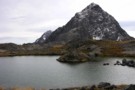
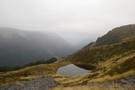
Rainbow Pass
Photograph
•
Distance: 5.1km away
looking across the tarn, the climb to the top of the pass is steeper than it looks in this photo ...
More ▶︎
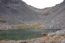
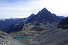
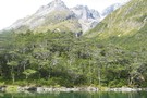
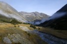
Rainbow Tarn
Photograph
•
Distance: 5.2km away
the tarn below Rainbow Pass, looking to Mt Travers - Apr 2011
More ▶︎
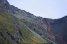
Rainbow Pass from the south
Photograph
•
Distance: 5.4km away
Rainbow Pass: a steep, tricky pass with serious exposure. I took the green route shown ... the red may, or ...
More ▶︎
Travers Pass
Photograph
•
Distance: 5.4km away
Looking down onto Travers Pass from Rainbow Pass. The main track is on the far side.
More ▶︎
Blue Lake
Track
•
2 – 4 days. Easy/medium. Return via same track.
•
Distance: 5.6km away
Blue Lake is a small, pretty lake dammed by boulders at the head of the Sabine Valley. Beyond is Lake ...
More ▶︎
Waiau - Clarence Pass Lake Tennyson Circuit
Track
•
4 – 5 days. Medium/hard. Loop track.
•
Distance: 5.8km away
A challenging 4-5 day circuit in the St. James Conservation Area / Nelson Lakes National Park featuring two alpine pass ...
More ▶︎

Profile : St Arnaud - Lewis Pass
Photograph
•
Distance: 6.0km away
A useful profile of the 100km tramp - with a couple of bad weather alternatives :
1. low route past Speargrass ...
More ▶︎

St Arnaud - Lewis Pass
Article
•
Distance: 6.0km away
A 9-day 100km tramp via the Thompson, D'Urville and 3 Tarns Passes
Feb 2013
More ▶︎
Begley Hut
Photograph
•
Distance: 6.1km away
An old NZ Forest Service hut up the Begley Valley. Fire doesn't draw well and door has to be left ...
More ▶︎
Begley Hut
Hut
•
Standard Hut (DOC). Capacity: 8.
•
Distance: 6.1km away
An old NZ Forest Service hut up the Begley Valley. Fire doesn't draw well and door has to be left ...
More ▶︎
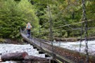
previous West Sabine bridge
Photograph
•
Distance: 6.4km away
washed away in 2012 and replaced with one just upstream of West Sabine hut
More ▶︎
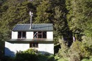
West Sabine Hut
Hut
•
Serviced Hut (DOC). Capacity: 34.
•
Distance: 6.5km away
Located in the West Branch of the Sabine River, south of Lake Rotoroa.
More ▶︎
West Sabine Hut
Photograph
•
Distance: 6.5km away
April 2010 - small wood burner inside....but sufficient
More ▶︎
Sabine Valley - Blue Lake - D'Urville Valley
Track
•
4 – 5 days. Medium. Circuit.
•
Distance: 6.5km away
A circuit along neighbouring valleys at the hear of Lake Rotoroa, passing the picturesque Blue Lake, and crossing Moss Pass. ...
More ▶︎
Blue Lake Jan 2007
Photograph
•
Distance: 6.5km away
This was a 'rite-of-passage' tramp for my 13 year old son. We helicoptered in to the Waiau Pass and then ...
More ▶︎
Hopeless Hut
Photograph
•
Distance: 6.5km away
A six bunk hut situated near Hopeless Creek, which is a tributary of the Travers River. The lower story is ...
More ▶︎
Hopeless Creek Hut
Hut
•
Standard Hut (DOC). Capacity: 6.
•
Distance: 6.5km away
An older , little used hut off the Travers Valley leading to Sunset Saddle and Angelus Hut.
More ▶︎
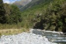
West Sabine River
Photograph
•
Distance: 6.5km away
West Sabine River, below West Sabine Hut, Nelson lakes
More ▶︎
West Sabine Bridge
Photograph
•
Distance: 6.5km away
Feb 2013 - Just upstream from the hut, the new bridge was a pleasant surprise as the DOC website didn't ...
More ▶︎
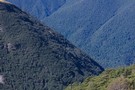
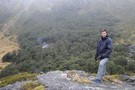
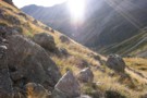
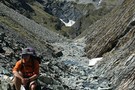
Tarns on range south of Mt Misery
Photograph
•
Distance: 7.8km away
Tarns below pt1609, rapidly losing their emerald colour as mist sets in..
Nearly at the end of a long climb ...
More ▶︎
Nelson Lakes - Angelus to Sunset Saddle
GPX file
•
Distance: 9.3km away
Route marked by cairns from Angelus Hut to Sunset Saddle. (The first part of the route to Hopeless Creek and ...
More ▶︎
Mount Misery Hut
Hut
•
Basic Hut/Bivvy (DOC). Capacity: 4.
•
Distance: 9.5km away
Mount Misery hut
More ▶︎
Over the Sabine River
Photograph
•
Distance: 9.8km away
First bridge after Sabine Hut, I think
More ▶︎
Nelson Lakes double figure eight with a reverse twist
Article
•
Distance: 9.9km away
January 2008.
A seven day epic up and over Lake Angelus from Speargrass Hut, then up the Sabine River, over Waiau ...
More ▶︎