Nearby
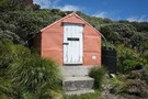
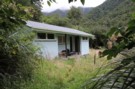
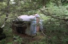
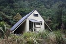
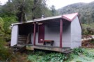
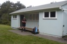
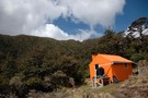
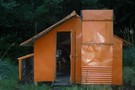
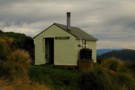
Smiths Stream Hut
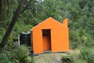
Smiths Stream Hut
Photograph
•
Distance: less than 100m away
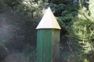
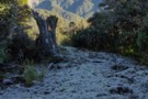
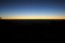
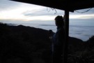
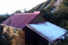
Smith Stream hut. taken 19-Apr-2009
More ▶︎
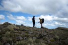
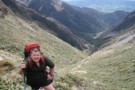
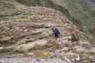
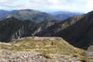
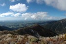
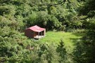
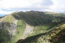
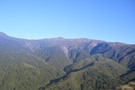
Broken Ridge, Ruahine
Photograph
•
Distance: 2.9km away
On Broken Ridge, above Hinerua hut. taken Dec 2009
More ▶︎
Walking the length of the Ruahines
Track
•
10 – 25 days. Medium/hard. One way.
•
Distance: 3.1km away
A 10+ day trip down to backbone of the Ruahine Range from Wharite (Palmerston Sth) to the Napier Taihape (Gentle ...
More ▶︎
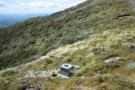
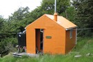
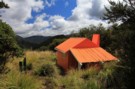
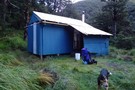
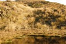
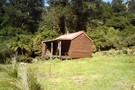
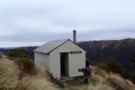
Tarn Bivvy
Hut
•
Basic Hut/Bivvy (DOC). Capacity: 2.
•
Distance: 4.4km away
Tarn biv, near the tarn on Black Ridge.
More ▶︎

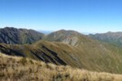
Sawtooth Ridge
Photograph
•
Distance: 5.0km away
Looking south along the Sawtooth towards Tiraha (Ruahine Ranges)
More ▶︎
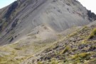
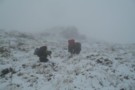
Waipawa Saddle
Photograph
•
Distance: 5.1km away
Moments before stepping over the lip onto the saddle and getting hammered by 100km/hr gusts very unpleasant
More ▶︎
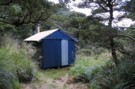
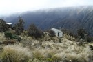
Waikamaka Bivouac (derelict)
Hut
•
Basic Hut/Bivvy (DOC).
•
Distance: 5.1km away
Waikamaka biv is derelict and overgrown, but it is still standing. Just across the stream from Waikamaka Hut.
More ▶︎
Waipawa Forks Hut 2012
Photograph
•
Distance: 5.1km away
Situated on a River Terrace about 50 minutes walk from the road end. No track, river travel all the way
More ▶︎
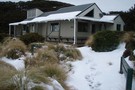
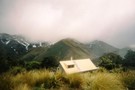
Waikamaka Hut 2012
Photograph
•
Distance: 5.1km away
Waikamaka Hut on a small terrace above the Waikamaka River 40 minutes downstream from Waipawa Saddle
More ▶︎
Top Maropea Hut 2012
Photograph
•
Distance: 5.1km away
Nice old four bunk hut in the Ruahine Range. In very good condition. About 25 minutes down a good track ...
More ▶︎
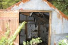
Waikamaka Bivouac interior
Photograph
•
Distance: 5.1km away
Waikamaka biv interior. taken 02-Jan-2010
More ▶︎
Waikamaka Bivouac 2012
Photograph
•
Distance: 5.1km away
February 2012. Still dry inside but very overgrown and gloomy
More ▶︎
Waikamaka Hut
Photograph
•
Distance: 5.1km away
Waikamaka Hut (It's there in the trees, honest - surely someone's got a better picture to replace this!)
More ▶︎
Walking the length of the Ruahines
Article
•
Distance: 5.1km away
This article documents my recollections of the Ruahine setion (Wharite to Kuripapango) of a walk from Wharite near Palmerston North ...
More ▶︎
Waikamaka Hut ( Herataunga TC)
Photograph
•
Distance: 5.1km away
A good tidy hut with Approx 8 bunk accommodation, enclosed wood burner and good wood supply available. A welcome refuge ...
More ▶︎
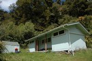
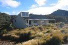
Waikamaka Hut
Hut
•
Standard Hut (Heretaunga Tramping Club). Capacity: 8.
•
Distance: 5.1km away
Waikamaka Hut sits in the headwaters of the Waikamaka Stream, 1.5km below the Waipawa Saddle, and below the pyramidical Te ...
More ▶︎
Waikamaka Hut loo
Photograph
•
Distance: 5.1km away
Waikamaka hut has a loo like a rocket ship.
More ▶︎
Waterfall Hut
Photograph
•
Distance: 5.2km away
An older hut in the heart of the Ruahines at the head of the Kawhatau River
More ▶︎
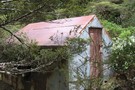
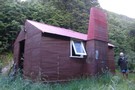
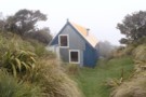
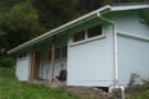
Waterfall Hut (Ruahine Ranges)
Hut
•
Standard Hut (DOC). Capacity: 6.
•
Distance: 5.2km away
An older hut in the head of the Kawhatau River in the heart of the Ruahines
More ▶︎

Benifits of Walking Friday
Photograph
•
Distance: 5.6km away
When there's nobody else around you can use as many mattresses as it takes to get a comfy bed.
More ▶︎
Waipawa Forks Hut
Photograph
•
Distance: 5.6km away
Nestled above the river on the true right side, this hut is a bit rough and has been vandalized to ...
More ▶︎
Waipawa Forks Hut
Hut
•
Standard Hut (DOC). Capacity: 12.
•
Distance: 5.6km away
A bit rough considering it's a newer DOC hut - vandalism in the bunkroom on the right. 5 minutes up ...
More ▶︎
Turn off to Pourangaki
Photograph
•
Distance: 5.7km away
Signpost marking the spur down to Pourangaki Hut off the ridge running SE from Mangaweka (Ruahine Ranges).
More ▶︎
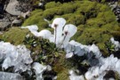
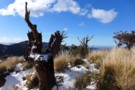
2 ice flowers
Photograph
•
Distance: 6.1km away
2 ice flowers near Mt Te Atuaoparapara. April 2009
More ▶︎

3 ice flowers
Photograph
•
Distance: 6.2km away
3 ice flowers near Mt Te Atuaoparapara. April 2009.
More ▶︎
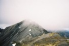
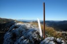
Te Atuaoparapara
Photograph
•
Distance: 6.2km away
Te Atuaoparapara, south ridge (Ruahine Ranges)
More ▶︎
Te Atuaoparapara
Photograph
•
Distance: 6.2km away
Ruahine Range. The Highest point between Sunrise Hut and Waipawa Saddle (1687 metres)The route between the saddle and Sunrise Hut ...
More ▶︎
Te Atuaoparapara, Ruahine Forest Park
Photograph
•
Distance: 6.2km away
What a day for tops travel! There are views over the Hikurangi Range, the Waikamaka Valley, Hawkers Bay, the Tongariro ...
More ▶︎
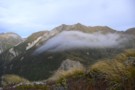
Ruahine Frost
Photograph
•
Distance: 6.3km away
Heading down the track to Pourangaki River, looking across to the Pourangaki tops. Heavy frost on the ground all day ...
More ▶︎
Triple X hut
Hut
•
Standard Hut (DOC). Capacity: 12.
•
Distance: 6.5km away
Nice hut for camps, families etc
Only 15 min from road end with alot of space for camping etc
More ▶︎
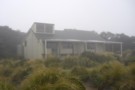
Sunrise Hut
Hut
•
Serviced Hut (DOC). Capacity: 20.
•
Distance: 6.7km away
Popular day trip and weekend hut with great views over Hawkes Bay. Located in Buttercup Hollow on the Ruahine Range. ...
More ▶︎
Sunrise hut
Photograph
•
Distance: 6.7km away
Sunrise hut in the early morning sun. April 2009
More ▶︎
Sunrise from Sunrise hut
Photograph
•
Distance: 6.8km away
Sunrise from Sunrise hut. taken April 2009
More ▶︎
Buttercup Hollow, Ruahine FP
Photograph
•
Distance: 6.8km away
Looking north up the range from Sunrise Hut on a crisp Winter's day.
More ▶︎
Howletts Hut
Photograph
•
Distance: 7.2km away
Howletts is in an idylic spot, in a hollow on the ridge top
More ▶︎
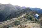
Waiting for the sunrise at Howletts
Photograph
•
Distance: 7.2km away
Howletts is ideally positioned to view the sun rising over Hawkes Bay
More ▶︎
Howletts Hut
Hut
•
Standard Hut (Heretaunga Tramping Club). Capacity: 8.
•
Distance: 7.2km away
Howletts Hut is located below the 1682m Taumatamekura Peak and the last rest heading north before the infamous Sawtooth Ridge.
The ...
More ▶︎
Longview Howletts Daphne Circuit
Track
•
2 – 3 days. Medium. Loop track with a road section.
•
Distance: 7.2km away
A circuit in the Ruahines taking in three well equiped huts
More ▶︎
Longview Howletts Daphne Circuit
GPX file
•
Distance: 7.2km away
A circuit in the Ruahines taking in three well equiped huts
More ▶︎
Howletts Hut
Photograph
•
Distance: 7.2km away
Tucked into a fold in the ridge a welcome site on a bad day
More ▶︎
Armstrong saddle
Photograph
•
Distance: 7.3km away
Armstrong saddle with Ruapehu in the background. April 2009.
More ▶︎

Armstrong Saddle
Photograph
•
Distance: 7.3km away
Above Armstrong Saddle looking down onto Sunrise Hut and Central Hawke's Bay. Even Tomato Hill by Havelock North can be ...
More ▶︎

Armstrong Saddle
Photograph
•
Distance: 7.3km away
Above Armstrong Saddle looking down onto Sunrise Hut and Central Hawke's Bay. Even Tomato Hill by Havelock North can be ...
More ▶︎
Daphne Hut
Photograph
•
Distance: 7.4km away
Showing Daphne Hut's location on the river bank
More ▶︎
Daphne Hut
Hut
•
Standard Hut (DOC). Capacity: 8.
•
Distance: 7.4km away
8 to 10 person hut.It's in a stunning spot where the northern and western branches of the Tukituki converge. Note, ...
More ▶︎
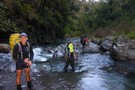
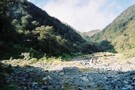
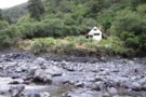
Pourangaki River
Photograph
•
Distance: 7.5km away
Heading down the Pourangaki River from the swingbridge to Kelly Knight Hut. This was one of the first of 44 ...
More ▶︎

Ruahines, looking West from Armstrong Saddle
Photograph
•
Distance: 7.5km away
Great views to be had from the saddle at any time of year (assuming you can get to it, the ...
More ▶︎
Pourangaki Hut
Photograph
•
Distance: 7.7km away
Last day of Autumn, with frost on the ground all day.
Cosy little hut in the Ruahines, although the toilet can ...
More ▶︎
Purity Mangaweka Kelly Night loop
Track
•
2 days. Medium. Loop track.
•
Distance: 7.9km away
Two huts, open tops, fantastic views on a fine day typical Ruahine travel.
More ▶︎
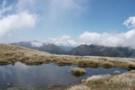
Tarn - Armstrong Saddle, Ruahine FP
Photograph
•
Distance: 7.9km away
A beautiful walk (when the wind permits) across Armstrong Saddle takes you down to Top Maropea or over the tops ...
More ▶︎
Triple X hut
Photograph
•
Distance: 7.9km away
Nice hut good for school camps etc only a short walk in with 12 bunks
More ▶︎
Waipawa Forks Hut
Photograph
•
Distance: 7.9km away
Nice hut just 5 min climb from waipawa river. Abit of grafitti but other then that its ok. completed the ...
More ▶︎
Sunrise Hut
Photograph
•
Distance: 7.9km away
Very nice hut/house, just happened to go on the one rainy day all last week, still enjoyable though
More ▶︎
Te Atuaoparapara
Photograph
•
Distance: 7.9km away
Nice day for a walk over to Top Maropea hut with wiew up to
Te Atuaoparapara
More ▶︎
The route from Longview Hut to Howletts Hut
Photograph
•
Distance: 8.0km away
This photo is taken from Daphne Ridge on the way to Howletts Hut. Longview is behind the higest point on ...
More ▶︎
Towards Mangaweka Trig in July
Photograph
•
Distance: 8.2km away
Late July 2008, photo taken from Wooden Peg, had planned to walk out to the trig but I was not ...
More ▶︎
Top Maropea Hut
Hut
•
Standard Hut (DOC). Capacity: 4.
•
Distance: 8.2km away
A gem of an old NZFS hut built in the 60s or 70s for deer cullers, this hut is a ...
More ▶︎
Ruahine Bush
Photograph
•
Distance: 8.2km away
Just below the bush line from Wooden peg to Kelly Knight Hut.
More ▶︎
Pourangaki Hut
Photograph
•
Distance: 8.3km away
Pourangaki Hut from the Porangaki - Hikurangi track
More ▶︎
Pourangaki Hut
Hut
•
Standard Hut (DOC). Capacity: 8.
•
Distance: 8.3km away
Pouragaki Hut (8-bunk, stove, tank water) is a warm, sheltered hut in a north-facing grassy basin above the Pourangaki River, ...
More ▶︎
Pourangaki Hut
Photograph
•
Distance: 8.3km away
A warm sheltered hut in the upper Pourangaki valley in the Ruahine Ranges
More ▶︎
Top Maropea Hut
Photograph
•
Distance: 8.4km away
Top maropea hut August 2009 on fine day after recent snow
More ▶︎
Top Maropea Hut
Photograph
•
Distance: 8.4km away
Lovely old NZFS hut built for deer cullers in the 60s or 70s, it has been repainted, however remains cold ...
More ▶︎
Top Maropea Hut at dawn
Photograph
•
Distance: 8.4km away
Very tidy little 4 bunk historic hut in Ruahine FP. Excellent camping spot just a few metres away.
More ▶︎
Shelter from the storm; a celebration of the six-bunker
Photograph
•
Distance: 9.0km away
Where would be without all those NZ Forest Service six-bunk huts in the Tararuas & Ruahines? Maybe that deer explosion ...
More ▶︎
Awatere Hut
Photograph
•
Distance: 9.7km away
Nice walk over ridge from kashmir road end, road is abit dodgy now that they have run a grader over ...
More ▶︎
Longview hut on ridge
Photograph
•
Distance: 9.7km away
The small white dot on the rige is longview hut from the ridge on the way to awatere hut
More ▶︎
Walking out.
Photograph
•
Distance: 9.8km away
This is taken the day after my first photo i added. If we walked in that day I dont think ...
More ▶︎
McKinnon Hut
Hut
•
Standard Hut (DOC). Capacity: 6.
•
Distance: 9.8km away
Start with a novelty cable car ride across the river and then straight in to a hard uphill slog. Track ...
More ▶︎
McKinnon Hut
Photograph
•
Distance: 9.8km away
Perched at 1400m on the side of the Hikurangi Range in the northern Ruahines, McKinnon Hut is a 1960's 6 ...
More ▶︎
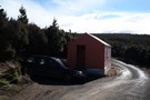
Gold Creek Hut
Hut
•
Basic Hut/Bivvy (DOC). Capacity: 4.
•
Distance: 9.9km away
Gold Creek Hut
More ▶︎