Nearby
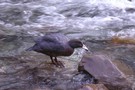
Looking down Kakapo River Oct 2010
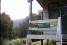
Great place for a snack
Photograph
•
Distance: 2.9km away
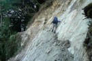
Doing my Garfield act on the last day of the Wangapeka
More ▶︎
Wangapeka Track
Track
•
4 – 5 days. Medium. One way.
•
Distance: 2.9km away
A Long gold trail following a series of river valleys.
More ▶︎
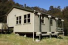
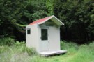
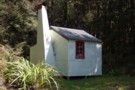
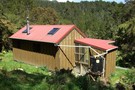
Taipo Hut, Kahurangi
Hut
•
Standard Hut (DOC). Capacity: 16.
•
Distance: 3.2km away
Hut on the Wangapeka Track leading up to Little Wanganui Saddle. This is the last night before crossing the saddle ...
More ▶︎
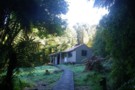
Taipo hut Oct 2010
Photograph
•
Distance: 3.2km away
This is one of the last of the NZ Forest Service built huts before DOC days in the Nelson Conservancy ...
More ▶︎

Leslie-Karamea
Track
•
3 – 4 days. Medium. One way.
•
Distance: 3.2km away
Joins onto Wangapeka Track.
More ▶︎
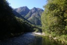
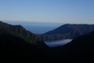
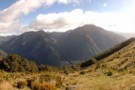
Looking SE over Zetland Basin Jan 2018
Photograph
•
Distance: 4.0km away
I took this photo when returning to the track after some time roaming the tops in the Mt Zetland area ...
More ▶︎
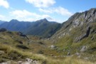
Little Wanganui
Photograph
•
Distance: 4.1km away
Little Wanganui valley ... and the Tasman, from the pass with the Taipo
More ▶︎
Stag Flat from the saddle
Photograph
•
Distance: 4.1km away
Stag Flat from the saddle between the Taipo and Little Wanganui. A tidy 2-bunk hut lies at the eastern end, ...
More ▶︎
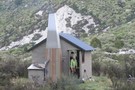
Stag Flat Shelter
Photograph
•
Distance: 4.1km away
This shelter replaced a hut that was nearby. It is on the edge of Stag Flat which is on the ...
More ▶︎
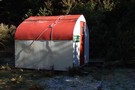
Stag Flat Shelter
Hut
•
Basic Hut/Bivvy (DOC). Capacity: 2.
•
Distance: 4.4km away
brilliant little 2 person shelter. taipo hut is boring and ugly so if you're heading towards the coast make the ...
More ▶︎
Little Wanganui Gorge Shelter
Photograph
•
Distance: 4.7km away
Little Wanganui Gorge Shelter or Wangapeka biv. taken Jan 2015.
More ▶︎

Little Wanganui Gorge Shelter name
Photograph
•
Distance: 4.7km away
The latest name for Wangapeka biv, Little Wanganui Emergency shelter etc. Taken Jan 2015.
More ▶︎
Wangapeka biv June 2009
Photograph
•
Distance: 4.8km away
[Also known as Little Wanganui Emergency Shelter & Little Wanganui Bivvy]
This biv is situated in the headwaters of the ...
More ▶︎
Wangapeka biv
Hut
•
Basic Hut/Bivvy (DOC). Capacity: 2.
•
Distance: 4.8km away
[Also known as Little Wanganui Emergency Shelter & Little Wanganui Bivvy]
This biv is situated in the headwaters of the Little ...
More ▶︎
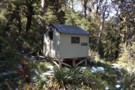
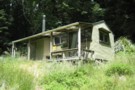
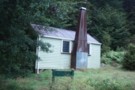
Kakapo hut Oct 2010
Photograph
•
Distance: 5.1km away
Kakapo hut is near the river on the TL bank of the middle reaches of the Kakapo River. The Kakapo ...
More ▶︎
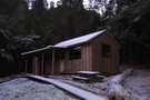
Kakapo hut
Hut
•
Basic Hut/Bivvy (DOC). Capacity: 4.
•
Distance: 5.1km away
Kakapo hut is near the river on the TL bank of the middle reaches of the Kakapo River. The Kakapo ...
More ▶︎

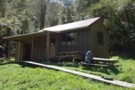
Trevor Carter Hut
Photograph
•
Distance: 5.6km away
Trevor Carter Hut, July 2009, I spent 2 days here waiting for the rain and thunder to stop.
More ▶︎
Trevor Carter Hut
Hut
•
Standard Hut (DOC). Capacity: 12.
•
Distance: 5.6km away
A new 12 bunk DOC hut on the Karamea River
More ▶︎
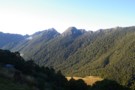
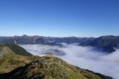
Biggs Tops
Photograph
•
Distance: 6.5km away
Biggs Tops looking into the Kendall Valley and down the Karamea River from behind Trevor Carter Hut.
More ▶︎
Little Wanganui Hut (Removed)
Hut
•
Removed!
•
Distance: 7.7km away
Former hut on TL of Little Wanganui River.
More ▶︎
Mt Arthur to Murchison
GPX file
•
Distance: 8.0km away
track from Mt Atrhur Tablelands to Murchison via Wangapeka Saddle, Nugget Knob and the Matiri Valley
More ▶︎
Belltown Hut
Photograph
•
Distance: 8.3km away
Belltown Hut ... the western end of the ranges and the start of the brief coastal plain before the Tasman. ...
More ▶︎
Rear view of Bell Town hut Oct 2010
Photograph
•
Distance: 8.3km away
Taken on a sunny day.
[Bell Town hut is located more or less right on top of an old prospectors camp. ...
More ▶︎
Bell Town hut Oct 2010
Photograph
•
Distance: 8.3km away
The place looks more inviting in this sunny day shot than in the early morning winter 2009 shot I posted.
...
More ▶︎
Bell Town / Manunui hut
Hut
•
Serviced Hut (DOC). Capacity: 10.
•
Distance: 8.3km away
A replacement hut for the Little Wanganui hut that was a little upstream on the other side of the river. ...
More ▶︎
Bell Town hut June 2009
Photograph
•
Distance: 8.3km away
Picture of the hut taken early on a frosty morning.
More ▶︎
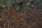
Fuchsia forest - route to Biggs Tops
Photograph
•
Distance: 8.5km away
Fuchsia forest - route to Biggs Tops
More ▶︎
Thor Hut
Hut
•
Standard Hut (DOC). Capacity: 6.
•
Distance: 9.1km away
A standard DOC hut on the Karamea River.
More ▶︎
Matiri Valley to Wangapeka Saddle
GPX file
•
Distance: 9.4km away
An interesting cross country trip in Kahurangi National Park
More ▶︎