Nearby
Mt Christina
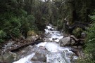
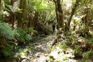
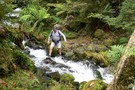
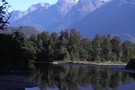
Lake Marian
Track
•
Easy/medium. Return via same track.
•
Distance: 2.6km away
Short walk from the Hollyford Road up to a hanging valley and lake in the Darran Mountains.
More ▶︎
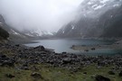
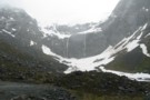
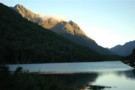
Lake Marian
Photograph
•
Distance: 2.7km away
Taken in October 2010 the lake appeared tiny in comparison to other photos and videos Ive seen of it online, ...
More ▶︎
Falls Creek
Track
•
1 – 2 days. Medium. Return by the same track.
•
Distance: 3.7km away
Day or overnight trip to a choice of two rock bivvies off the Milford Road.
More ▶︎
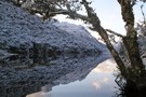
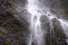
Marian Creek
Photograph
•
Distance: 4.4km away
Taken from the viewing gantry, an easy 10 minute walk from the carpark, Marian creek tumbles down the hillside on ...
More ▶︎
Homer Hut
Hut
•
Serviced Hut (NZAC). Capacity: 30.
•
Distance: 4.6km away
Well-equipped NZAC hut located in the Gertrude Valley east of the Homer Tunnel. This hut is most popular with climbers ...
More ▶︎
Phil's Biv
Rock bivouac
•
Distance: 5.8km away
Rock biv high above the head of lake Adelaide, beneath Marian Peak. Several rocks provide rooms with benches.
Note: Approximate ...
More ▶︎
The Divide Shelter
Hut
•
Shelter (DOC).
•
Distance: 5.9km away
Open shelter at the Milford end of the Routeburn Track. Overnight use prohibited.
More ▶︎
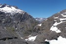
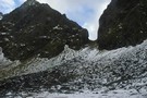
Gertude Saddle
Photograph
•
Distance: 6.3km away
In the Gertrude Valley, just the Te Anau side of the Homer Tunnel. One of the best day walks in ...
More ▶︎
Routeburn Track
Track
•
2 – 4 days. Easy/medium. One way.
•
Distance: 6.5km away
An internationally renowned and popular alpine crossing between Fiordland and Lake Wakatipu.
More ▶︎
Boyd Creek to The Divide via Kiwi Burn and the Mavora Walkway
Article
•
Distance: 6.5km away
A New Year's trip through the Snowdon Forest and on to The Divide. Heavily affected by weather, I had to ...
More ▶︎
Not The Routeburn
GPX file
•
Distance: 6.5km away
A six-passes, seven catchments trip through the Humboldt Mountains from Glenorchy to The Divide.
Note that for access from Double Barrel ...
More ▶︎

Haast to The Divide
GPX file
•
Distance: 6.5km away
Andrew Barker's traverse 2009. From Pleasant Flat in the Haast to The Divide via Mt Aspiring National Park.
More ▶︎
Gill's Biv
Rock bivouac
•
Distance: 6.6km away
A large rock dropped of the Darran Range, located at the head of Lake Adelaide. Mike Gill identified the biv ...
More ▶︎
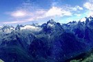
Parorama from Harris Saddle
Photograph
•
Distance: 6.6km away
several photographs put together to create a panoramic view
More ▶︎
Key Summit
Track
•
Easy. Return via same track.
•
Distance: 6.6km away
Short, easy walk at the start of the Routeburn Track to a low summit. Panoramic views of the Greenstone, Hollyford, ...
More ▶︎
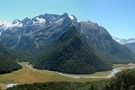
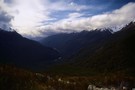
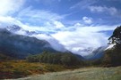
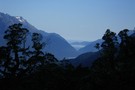
Hollyford Valley
Photograph
•
Distance: 6.7km away
The Hollyford Valley floor sits just above sea level, while the Routeburn Track creeps along the Serpentine Range at around ...
More ▶︎
Howden Hut
Hut
•
Great Walks Hut (DOC). Capacity: 28.
•
Distance: 7.0km away
Hut on the Routeburn Track, destroyed by a landslide in February 2020.
More ▶︎
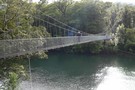
THE START OF THE DEMON TRAIL
Photograph
•
Distance: 7.1km away
Over this bridge the trail starts to live up to its name
More ▶︎
Hollyford Track
Track
•
4 days. Medium. One way.
•
Distance: 7.1km away
The Hollyford Track is a classic lowland Fiordland route from the Hollyford Road out to the coast at Martins Bay.
More ▶︎
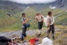
fiordland for fun
Photograph
•
Distance: 7.2km away
Kevin and Jamie are the adventurers whose experiences are recorded in the 'First Crossings " TV series first shown on ...
More ▶︎

Great Walks Information
Article
•
Distance: 7.3km away
The DOC Great Walks are a set of premium tramping tracks throughout New Zealand.
More ▶︎
Lake Howden
Photograph
•
Distance: 7.6km away
Summer at Lake Howden is a magic time. The wind is warm, days are hot and sunny, and the fellow ...
More ▶︎
Greenstone Saddle Camping Area
Campsite
•
Informal campsite (DOC).
•
Distance: 8.0km away
Large informal campsite at Greenstone Saddle, near the top of the Greenstone Track.
More ▶︎
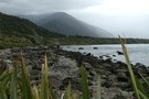
View from Lake Alabaster
Photograph
•
Distance: 8.2km away
mountain shot from Lake Alabaster
More ▶︎
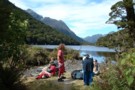
Morning at the Greenstone Saddle Camping Area.
Photograph
•
Distance: 8.3km away
Morning at the Greenstone Saddle Camping Area. McKellar Saddle, cloaked in cloud and dusted with snow, is left of centre.
More ▶︎
Greenstone Track
Track
•
2 – 3 days. Easy. One way.
•
Distance: 8.3km away
A famous, easy track along red tussock river flats.
More ▶︎
U Pass
Track
•
1 – 2 days. Medium. Loop track.
•
Distance: 8.4km away
A short loop track in the Earl Mountains.
More ▶︎
The Orchard
Photograph
•
Distance: 8.5km away
Open space edged by ribbonwood near Lake Mackenzie.
More ▶︎
Earland Falls
Photograph
•
Distance: 8.8km away
A 174m watterfall that the Routeburn track passes right underneath.
More ▶︎
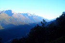
The Darran Mountains
Photograph
•
Distance: 9.3km away
Taken from the Routeburn North of The Orchard, almost the whole length of the Hollyford valley is visible with Lake ...
More ▶︎
Lake Gunn to Falls Creek.
Track
•
1 – 2 days. Hard. One way.
•
Distance: 9.8km away
A challenging day trip or overnight trip in Fiordland.
More ▶︎