More information
Walking Notes: Crater Rim Walkway
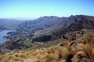
The Port Hills are a distinctive feature of the
Christchurch skyline, being part of the extinct Lyttelton Volcano.
Although largely cleared of natural vegetation by past burning,
pockets remain, and substantial revegetation work has been
undertaken. Walking is exposed to sun and wind, and ...
More ▶︎
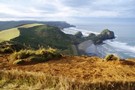
Unnamed side track, Crater Rim Walkway
Track.
Easy. One way.
Created
23 November 201623 November 2016.
An alternate route with harbour views near the Sign of the Kiwi.
More ▶︎
Crater Rim Walkway: Ahuriri to Sign of the Bellbird
The southernmost section of the Crater Rim Walkway in the Christchurch Port Hills.
More ▶︎
Crater Rim Walkway: Sign of the Bellbird to Sign of the Kiwi
Short section between two of the original Summit Road rest houses on the Crater Rim Walkway.
More ▶︎
Crater Rim Walkway: Sign of the Kiwi to Rapaki Rock
Short section past Sugarloaf and Mount Vernon.
More ▶︎
Crater Rim Walkway: Bridle Path to Mount Pleasant
Short section of the Crater Rim Walkway from the top of the Bridle Path, past Mount Cavendish and on to Mount Pleasant.
More ▶︎
Crater Rim Walkway: Rapaki Rock to Bridle Path
Short section of Christchurch's Crater Rim Walkway.
More ▶︎
Day walks for Alert Level 3
As we head into Alert Level 3, Government advice supports day works on easy trails. Alrighty then! Here's some iso inspo.
More ▶︎