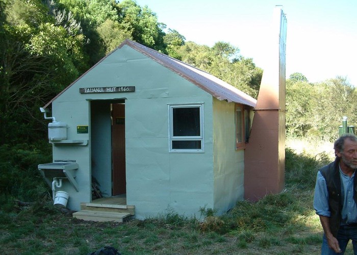
Tauanui Hut
Aorangi Forest Park
A standard 6-bunk forestry hut in the northern Haurangi Ranges. Open fire, river water + 20l roof tank (soya oil tin). Plenty of firewood around, but judging from the hut book, an empty wood store is the norm. The hut sits in a large grassy clearing, separated from the river by a band of exotic scrub. Behind the hut the valleyside is podocarp bush for the first 100m, above which beech takes over. Upriver and opposite, beech also dominates.
The only hut north of Sutherland Road - and a long way from formal tramping tracks, this hut gets very little tramping traffic. Access is 'walking only' according to DOC, with landholder's permission - though an ATV track runs all the way to the hut, and gets some use from hunters. 8km on farm/forestry tracks, then 3km winding up river on a quad track.
Mt Te Maunga can be climbed by ascending the ridge behind the hut. A large clearing on the summit promises views on a clear day. Crossing to Sutherland Hut is possible.
|
Owner
|
Owner: DOC |
|---|---|
|
Category
|
Standard Hut |
|
Sleeps
|
Sleeps 6
6
|
|
Facilities
|
Toilet, Open fireplace |
|
Water supply
|
Tap or tank water |
|
Getting there
|
McDouglas Road, Pirinoa: 11km (2.5-4 hrs), 4wd / ATV track Sutherlands Hut: 10km (5.5-11hrs). Tough ridgeline route requiring map + compass + good navigational skill. Climb 600m to Te Maunga, then follow ridgeline SW, S to forks 1km downriver of Sutherland Hut. Climb is scrubby for 200m, but otherwise good. 3 points on ridgeline where ridge down off summits is not visible from summit and good navigational skills required. Last 100m to river steep & loose. |
|---|---|
|
Unlocked
|
This hut is unlocked and open to access. |
|
Bookings
|
No bookings — open access
No — open access
|
|
Altitude
|
200m |
|---|---|
|
Mobile phone coverage
|
No coverage |
|
Maps
|
NZTopo50-BQ33
|
|
Link
|
www.doc.govt.nz/p...http://www.doc.govt.nz/parks-and-recreation/places-to-stay/backcountry-huts-by-region/wairarapa/wairarapa/tauanui-hut/ |