Nearby
Mount Te Kinga Lake Brunner
Mount Te kinga
Photograph
•
Distance: less than 100m away
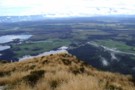
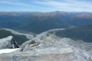
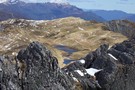
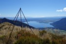
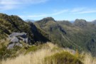
Looking down on Cashmere and Iveagh Bays from summit of Mt Te kinga
More ▶︎
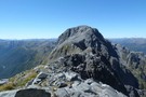
Mts Te Kinga & Alexander August 2011
Photograph
•
Distance: less than 100m away
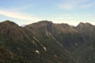
This photo looks along the Te Kinga tops from the low peak near the trig to the top of Te ...
More ▶︎
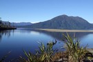
Mt Te Kinga
Photograph
•
Distance: 921m away
This pic looking across Lake Brunner to Mt Te Kinga was taken from the spit at the mouth of the ...
More ▶︎
Te Kinga tops
Photograph
•
Distance: 921m away
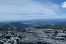
This pic shows the trig near the track terminus and the view to the SE. This is not the highest ...
More ▶︎
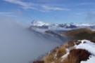
Mt Alexander
Photograph
•
Distance: 4.8km away
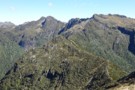
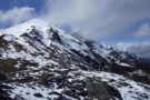
Looking down on the confluence of the Otira and Taramakau rivers from Summit of Mt Alexander
More ▶︎
Mount Alexander
Track
•
2 days. Medium. Return by the same track.
•
Distance: 4.8km away
A long climb to the summit of Mount Alexander (1958m) on the Kaimata Range. This range lies directly north of ...
More ▶︎
Mt Alexander
Photograph
•
Distance: 4.8km away
Looking back at point 1786 ,Mt Tekinga, Lake Brunner, Kangaroo Lake, Lady Lake and Swan lake
More ▶︎
Valenski Walk
GPX file
•
Distance: 5.2km away
Smooth and easy walking track climbing through podocarp forest at Moana.
More ▶︎
Rakaitane Walk
Track
•
Easy. Loop track.
•
Distance: 5.2km away
A short partial loop exploring forest at Moana.
More ▶︎
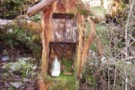
Mailbox at Camp Creek hut Sept 2010
Photograph
•
Distance: 7.1km away
Located on the side track just before the hut.
Doesn't look like the milkman has called for a while!
More ▶︎
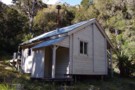
Camp Creek hut
Hut
•
Standard Hut (DOC). Capacity: 9.
•
Distance: 7.1km away
This hut is located 3kms up the Camp Creek access track to the Alexander/Kaimata Range tops. A sign at the ...
More ▶︎
Camp Creek hut Sept 2010
Photograph
•
Distance: 7.1km away
This hut is located 3kms up the Camp Creek access track to the Alexander/Kaimata Range tops. A sign at the ...
More ▶︎
Bain Bay
Track
•
Easy. Return via same track.
•
Distance: 7.8km away
Lakeside walk through swampy kahikatea groves and rich podocarp forest, Lake Brunner.
More ▶︎
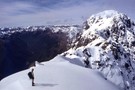
Tarns on the tops above Camp Creek hut Sept 2010
Photograph
•
Distance: 8.2km away
These tarns are a short walk SW along the range from where the tops track emerges. Most people head along ...
More ▶︎
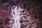
On top of Carew Falls mid 1970's
Photograph
•
Distance: 8.4km away
This pic is about 35 years old. Carew Falls have been a tourist attraction since the early 1900's. Presumably promotion ...
More ▶︎
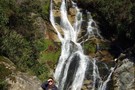
Carew Falls June 2011
Photograph
•
Distance: 8.4km away
We popped into have a look at the falls yesterday. For me it was the first visit for many years. ...
More ▶︎
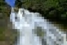
Carew Falls
Track
•
Easy. Return via same track.
•
Distance: 8.7km away
A brief climb to the Carew Falls behind the Lake Brunner Lodge
More ▶︎
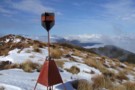
Mt Ruberslaw trig beacon etc Feb 2019
Photograph
•
Distance: 8.8km away
This photo shows an historic iron pipe trig (survey triangulation beacon) that remains standing on Mt Ruberslaw, Hohonu Range. It ...
More ▶︎
Heart of Hohonu Range from Mt Ruberslaw
Photograph
•
Distance: 8.8km away
Taken Feb 2019 this photo looks WNW to the main Hohonu Range from beside the Ruberslaw trig.
Many of the peaks ...
More ▶︎
Three Hohonu Peaks
Photograph
•
Distance: 9.2km away
This picture was taken in March 2013 from the Hohonu Ridge tops east of Castle Hill. i.e. This photo is ...
More ▶︎
Eastern Hohonu River headwaters
Photograph
•
Distance: 9.2km away
This photo view is SE in to the heart of the Hohonu Range from about 4km up river of the ...
More ▶︎
Taff Tor etc. Hohonu Range Feb 2019
Photograph
•
Distance: 9.2km away
I took this photo when traversing southward down the Hohonu Range.
Taff Tor which is the second high point just left ...
More ▶︎
Looking toward Mt Alexander from above Camp Creek hut Sept 2010
Photograph
•
Distance: 9.5km away
This picture was taken not far from where the tops track crests the ridge. Mt Alexander (1958m) is the back ...
More ▶︎