Nearby
Dasler Bivouac
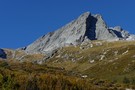
Dasler Pinnacles
Photograph
•
Distance: less than 100m away
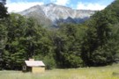
Dasler Pinnacles (2315m) from track through scrub above Dasler Biv.
More ▶︎
Dasler Pinnacles
Track
•
2 days. Medium/hard. Return via same track.
•
Distance: less than 100m away
This trail leads from the flat valley floor steeply up to Dasler Biv and beyond the the Pinnacles themselves.
More ▶︎
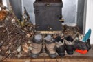
Dasler Bivouac
Hut
•
Basic Hut/Bivvy (DOC). Capacity: 2.
•
Distance: less than 100m away
Historic tin biv constructed in 1966 and located on the steep wall of the Hopkins Valley near the Dasler Pinnacles. ...
More ▶︎
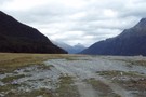
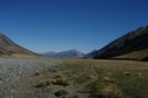
Hopkins Valley
Track
•
3 – 4 days. Easy/medium. Return via same track.
•
Distance: 3.3km away
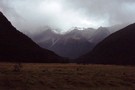
A very long, straightforward valley at the head of Lake Ohau.
More ▶︎
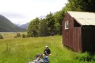
Elcho Hut, Hopkins
Photograph
•
Distance: 3.3km away
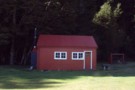
Owned by the New Zealand Alpine Club. taken in jan 09.
More ▶︎
Elcho Hut
Hut
•
Standard Hut (NZAC). Capacity: 12.
•
Distance: 3.3km away
Owned by the New Zealand Alpine Club. well maintained hut with a good view up the valley and close to ...
More ▶︎
Cullers Hut
Hut
•
Standard Hut (DOC). Capacity: 4.
•
Distance: 4.1km away
possibly an old forestry hut? nice old hut to stay in the summer time, can be abit cold either side ...
More ▶︎
Huxley Valley, Anita Peak from Red Hut
Photograph
•
Distance: 4.7km away
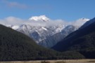
Huxley Valley, Anita Peak from Red Hut in the Hopkins
More ▶︎
Ruataniwha Conservation Park
Place
•
Conservation Park. 368.00km2.
•
Distance: 4.7km away
The Ruataniwha Conservation Park occupies a mountainous landscape, and includes the valleys of the Dobson, Hopkins, Huxley, Temple and Maitland ...
More ▶︎
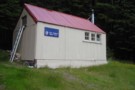
Red Hut
Hut
•
Standard Hut (DOC). Capacity: 12.
•
Distance: 4.7km away
Historic hut in the Hopkins Valley north of Lake Ohau. Constructed in 1916 for commercial tourism, and recently restored.
More ▶︎
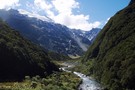
Huxley Valley
Photograph
•
Distance: 6.6km away
Huxley Valley, looking towards the Forks. Forks Hut is on flats at the base of the peak in the distance.
More ▶︎
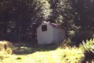
Dodger Hut
Photograph
•
Distance: 7.3km away
A quaint 4 bunk hut in a lovely setting on a grassy terrace above the Hopkins River
More ▶︎
Dodger Hut
Hut
•
Standard Hut (DOC). Capacity: 4.
•
Distance: 7.3km away
Located on flats near on the Hopkins River.
More ▶︎
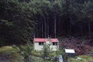
Monument Hut
Photograph
•
Distance: 7.9km away
Monument Hut, in the Hopkins - a handy evening walk in for those heading up the Hopkins or Huxley the ...
More ▶︎
Monument Hut
Hut
•
Standard Hut (DOC). Capacity: 6.
•
Distance: 7.9km away
Monument Hut (6 bunks, matresses, stove, firewood, river water) is a forestry style hut in the Hopkins. Its located just ...
More ▶︎
Huxley Valley
Track
•
2 days. Easy/medium. Return via same track.
•
Distance: 7.9km away
Easy walking at the head of Lake Ohau.
More ▶︎
Picton to Aspiring
GPX file
•
Distance: 7.9km away
An aborted alpine traverse. Picton to West Cape, but aborted at Aspiring due to real world emergencies back home. Posted ...
More ▶︎
Grough Hut
Hut
•
Basic Hut/Bivvy (DOC). Capacity: 2.
•
Distance: 8.3km away
The innacurately named Grough Hut (2 beds, 1 matress, no fire, water distant) is actually a very basic bivvy on ...
More ▶︎
Lower Dobson Valley
Photograph
•
Distance: 8.5km away
Lower Dobson Valley between Grough Hut and Le Crens Hut
More ▶︎
Le Crens Hut / L. A. Crens Hut
Hut
•
Private hut (PVT). Capacity: 4.
•
Distance: 8.6km away
L.A. Crens Hut (private?, 4 bunk, fireplace, stream water) is a historic station hut on Glen Lyon Station land in ...
More ▶︎
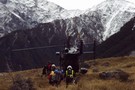
Otago rescue chopper, Huxley Valley
Photograph
•
Distance: 9.2km away
The Otago rescue chopper up the Huxley, called using an EPIRB (beacon) upon finding a party with an injured member ...
More ▶︎
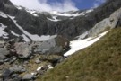
Cirque wall in Kea creek, below Elcho Pass.
Photograph
•
Distance: 9.5km away
We found a ok route along ledges to the true left of the waterfall, only had one steep drop about ...
More ▶︎
Huxley North Branch
Photograph
•
Distance: 9.6km away
The North Branch of the Huxley towards Brodrick Hut and Mt Strauchon
More ▶︎