Nearby
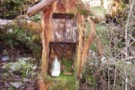
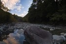
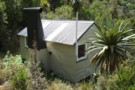
Jacko Flat hut Feb 2010
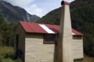
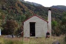
Jacko Flat hut
Hut
•
Basic Hut/Bivvy (DOC). Capacity: 6.
•
Distance: less than 100m away
An NZFS 1963 built six bunk hut on a flat in the middle sections of the Crooked River. The Crooked ...
More ▶︎
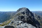
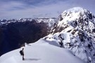
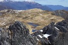
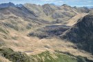
Mt Alexander
Photograph
•
Distance: 2.6km away
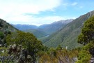
Looking down on the confluence of the Otira and Taramakau rivers from Summit of Mt Alexander
More ▶︎
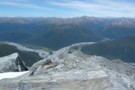
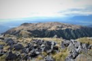
Mt Alexander
Photograph
•
Distance: 2.6km away
Looking back at point 1786 ,Mt Tekinga, Lake Brunner, Kangaroo Lake, Lady Lake and Swan lake
More ▶︎
Mount Alexander
Track
•
2 days. Medium. Return by the same track.
•
Distance: 2.6km away
A long climb to the summit of Mount Alexander (1958m) on the Kaimata Range. This range lies directly north of ...
More ▶︎
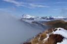
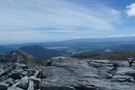
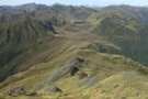
Mts Te Kinga & Alexander August 2011
Photograph
•
Distance: 2.7km away
This photo looks along the Te Kinga tops from the low peak near the trig to the top of Te ...
More ▶︎
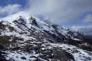
Looking toward Mt Alexander from above Camp Creek hut Sept 2010
Photograph
•
Distance: 3.6km away
This picture was taken not far from where the tops track crests the ridge. Mt Alexander (1958m) is the back ...
More ▶︎
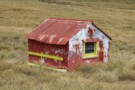
Top Crooked hut Feb 2010
Photograph
•
Distance: 5.0km away
JH relaxing with a cuppa outside the hut. Note rata flowering in the background.
More ▶︎
Top Crooked hut
Hut
•
Basic Hut/Bivvy (DOC). Capacity: 4.
•
Distance: 5.0km away
An ex NZFS four bunker in the headwaters of the Crooked River.
More ▶︎
Mailbox at Camp Creek hut Sept 2010
Photograph
•
Distance: 5.7km away
Located on the side track just before the hut.
Doesn't look like the milkman has called for a while!
More ▶︎
Camp Creek hut Sept 2010
Photograph
•
Distance: 5.7km away
This hut is located 3kms up the Camp Creek access track to the Alexander/Kaimata Range tops. A sign at the ...
More ▶︎
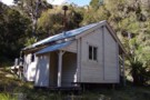
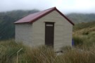
Camp Creek hut
Hut
•
Standard Hut (DOC). Capacity: 9.
•
Distance: 5.7km away
This hut is located 3kms up the Camp Creek access track to the Alexander/Kaimata Range tops. A sign at the ...
More ▶︎
Tarns on the tops above Camp Creek hut Sept 2010
Photograph
•
Distance: 6.0km away
These tarns are a short walk SW along the range from where the tops track emerges. Most people head along ...
More ▶︎
Harper Pass - Kiwi Saddle
Track
•
5 – 7 days. Medium. One way.
•
Distance: 6.6km away
A classic crossing of the Main Divide, following the deep valleys of the Hope Fault from the Arthur's Pass road ...
More ▶︎
Otehake Hot Springs
Track
•
2 days. Easy/medium. Return via same track.
•
Distance: 6.6km away
A popular weekend route to good hot pools.
More ▶︎
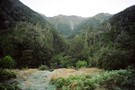
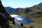
Looking toward Lake Morgan March 2010
Photograph
•
Distance: 8.1km away
This shot was taken from high on the slopes of Mt O'Shanessy & looks south to Lake Morgan. The hut ...
More ▶︎
Lake Morgan hut
Hut
•
Basic Hut/Bivvy (DOC). Capacity: 6.
•
Distance: 8.1km away
On the tops between the Haupiri & Crooked Rivers. The surrounding tops are something special! Lake Morgan is a half ...
More ▶︎
Cone Creek hut Feb 2010
Photograph
•
Distance: 8.9km away
In the West Branch of the Haupiri River.
Access from up the Haupiri River or by dropping off the Lake Morgan ...
More ▶︎
Cone Creek hut
Hut
•
Basic Hut/Bivvy (DOC). Capacity: 6.
•
Distance: 8.9km away
In the West Branch of the Haupiri River.
More ▶︎
Descent from Pfeifer Biv into Pfeifer Creek via scree
Photograph
•
Distance: 9.4km away
Unmarked route exiting basin where biv lies, maintaining altitude to cross a spur after 20 minutes then travelling northeast along ...
More ▶︎
Lake Morgan from Mt.O'Shanessy March 2019
Photograph
•
Distance: 9.5km away
Our first view of the basin containing Lake Morgan. We have just gone over the bouldery 1400m peak a short ...
More ▶︎
Westland tops with the Brian O'Lyn route March 2019
Photograph
•
Distance: 9.7km away
There are several approaches to the Lake Morgan.
This is a route from the north and that is partly marked on ...
More ▶︎
Paratu Stream - Waharoa Saddle
Article
•
Distance: 9.7km away
The easiest route to Mt Pfeifer via an attractive bouldered stream and a magical saddle with flybys of kaka and ...
More ▶︎
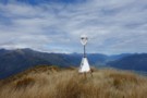
View SW from Granite Hill Nov 2018
Photograph
•
Distance: 9.8km away
This pic from the top of Granite Hill shows the surviving trig beacon. (Two other toppled trigs are also there) ...
More ▶︎