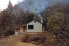
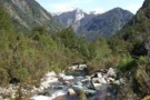
Nearby
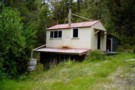
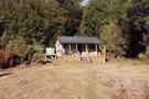
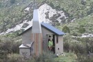
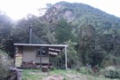
Thor Hut
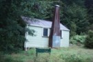
Thor Hut
Hut
•
Standard Hut (DOC). Capacity: 6.
•
Distance: less than 100m away
A standard DOC hut on the Karamea River.
More ▶︎

Leslie-Karamea
Track
•
3 – 4 days. Medium. One way.
•
Distance: less than 100m away
Joins onto Wangapeka Track.
More ▶︎
Mt Arthur to Murchison
GPX file
•
Distance: 2.5km away
track from Mt Atrhur Tablelands to Murchison via Wangapeka Saddle, Nugget Knob and the Matiri Valley
More ▶︎
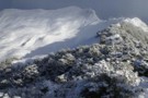
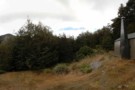
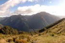
Luna Tops, Wangapeka
Photograph
•
Distance: 3.0km away
Overnight snow on the Luna Tops near Kiwi Saddle Hut, Wangpeka region
More ▶︎
Venus Hut
Hut
•
Standard Hut (DOC). Capacity: 12.
•
Distance: 4.0km away
Now a new 12 bunk hut on the Karamea River.
More ▶︎

Mt. Luna via the stone track
Track
•
3 days. Medium. 19hrs.
•
Distance: 5.2km away
Stone hut is a days march in from the Rolling river, taking the main Wangapeka track.From Stone hut ford the ...
More ▶︎

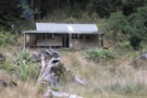
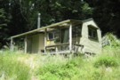
Trevor Carter Hut
Photograph
•
Distance: 6.4km away
Trevor Carter Hut, July 2009, I spent 2 days here waiting for the rain and thunder to stop.
More ▶︎
Trevor Carter Hut
Hut
•
Standard Hut (DOC). Capacity: 12.
•
Distance: 6.4km away
A new 12 bunk DOC hut on the Karamea River
More ▶︎
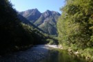
Crow Hut, Karamea River
Photograph
•
Distance: 7.1km away
Miners once fossicked for gold up the Crow River. Nowadays, Crow Hut sits as a silent sentinel of a bygone ...
More ▶︎
Crow Hut (Kahurangi)
Hut
•
Standard Hut (DOC). Capacity: 12.
•
Distance: 7.2km away
Tucked away on a terrace at the confluence of Crow River and the mighty Karamea River.
More ▶︎
kiwi saddle hut
Photograph
•
Distance: 7.3km away
6 bed doc hut open fire water stunning veiws
More ▶︎
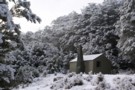
Kiwi Saddle Hut (Wangapeka)
Photograph
•
Distance: 7.3km away
Kiwi Saddle Hut after a light overnight snow.
More ▶︎
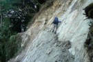
Fuchsia forest - route to Biggs Tops
Photograph
•
Distance: 7.4km away
Fuchsia forest - route to Biggs Tops
More ▶︎
Matiri Valley to Wangapeka Saddle
Track
•
4 – 6 days. Medium. One way.
•
Distance: 7.5km away
An interesting cross country trip in Kahurangi National Park involving a stretch of unmarked ridge travel
More ▶︎
Matiri Valley to Wangapeka Saddle
GPX file
•
Distance: 7.5km away
An interesting cross country trip in Kahurangi National Park
More ▶︎
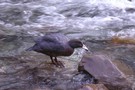
Blue duck / whio
Photograph
•
Distance: 7.6km away
The blue duck is an uncommon duck found on swiftly flowing rivers only in New Zealand. This one was swimming ...
More ▶︎
Stone Hut
Photograph
•
Distance: 7.6km away
Not made of stone but lots of stones on the track upstram from here
More ▶︎
Stone Hut
Photograph
•
Distance: 7.6km away
On the Wangapeka track. Very cosy. Saw Whio in the river adjacent to the hut.
More ▶︎
Stone Hut (Kahurangi)
Hut
•
Standard Hut (DOC). Capacity: 10.
•
Distance: 7.6km away
Stone Hut is situated on the banks of the Wangapeka River where it meets Stone Creek. The Wangapeka Track continues ...
More ▶︎
Kiwi Saddle Hut (Wangapeka)
Hut
•
Standard Hut (DOC). Capacity: 6.
•
Distance: 7.7km away
Six bunk hut in NZFS style. Tent sites available in clearing around hut. In early January 2007 there were a ...
More ▶︎
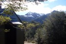
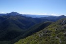
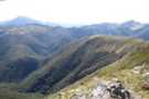
Biggs Tops
Photograph
•
Distance: 7.8km away
Biggs Tops looking into the Kendall Valley and down the Karamea River from behind Trevor Carter Hut.
More ▶︎
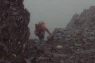
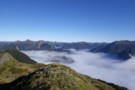
Looking down Kakapo River Oct 2010
Photograph
•
Distance: 9.1km away
This picture was taken soon after hitting the river after descending from Kakapo Saddle. Kakapo hut is about 3hrs down ...
More ▶︎
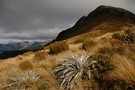
Mount Patriarch Tops
Photograph
•
Distance: 9.1km away
Mount Patriarch Tops, Kahurangi National Park.
More ▶︎
Wangapeka Saddle
Photograph
•
Distance: 9.5km away
Wangapeka Saddle from Nuggett Knob. Mt Luna to the right
More ▶︎
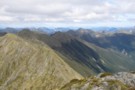
Matiri Wangapeka ridge from Nuggett Knob
Photograph
•
Distance: 9.5km away
This photo shows the whole ridge. Point 1442 above Hurricane Hut is in the middle and the tarn is on ...
More ▶︎
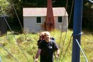
Great place for a snack
Photograph
•
Distance: 9.8km away
Doing my Garfield act on the last day of the Wangapeka
More ▶︎
Wangapeka Track
Track
•
4 – 5 days. Medium. One way.
•
Distance: 9.8km away
A Long gold trail following a series of river valleys.
More ▶︎