Nearby
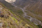
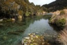
Hard going in the Oturere Stream
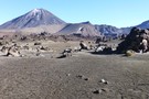
Routes from Oturere Bridge to Oturere Hut
GPX file
•
Distance: 435m away
Some years ago the prospect of a fast shortcut from Oturere Bridge to Oturere Hut has facinated me. I have ...
More ▶︎
Round The Mountain (Ruapehu) - Stage 2
GPX file
•
Distance: 5.4km away
This is a pleasant two-day walk around the eastern part of the Round The Mountain (Ruapehu) Track. The walk begins ...
More ▶︎
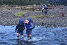
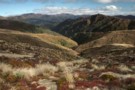
Mangahouhounui Stream
Track
•
2 days. Medium. One way.
•
Distance: 5.6km away
An untracked alternative to getting from Ketetahi Hut to Oturere Hut and beats the madenning crowd.
More ▶︎
Tongariro Northern Circuit
GPX file
•
Distance: 5.8km away
A complete log of the Tongariro Northern Circuit completed on March 8, 2008.
More ▶︎

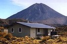
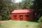
Oturere Hut
Hut
•
Great Walks Hut (DOC). Capacity: 26.
•
Distance: 5.9km away
A grand location on the east side of Ngauruhoe in the Tongariro National Park. The smallish living area has 2 ...
More ▶︎
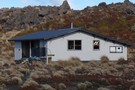
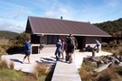
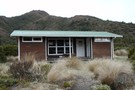
Oturere Hut
Photograph
•
Distance: 5.9km away
Northern tongariro circiut hut Gas burners and fire, Water and WC. Would be an intereting hut to visit mid winter
More ▶︎

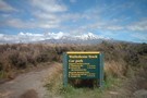
Great Walks Information
Article
•
Distance: 5.9km away
The DOC Great Walks are a set of premium tramping tracks throughout New Zealand.
More ▶︎
Tongariro Northern Circuit
Track
•
3 – 4 days. Easy/medium. Loop track.
•
Distance: 5.9km away
This circuit on the Volcanic Plateau passes close to the summit of Tongariro in a spectacular, active volcanic landscape of ...
More ▶︎
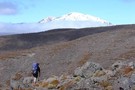
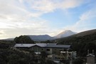
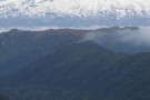
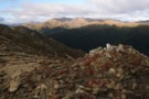
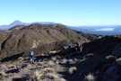
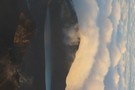
Traversing around Mt Tongariro
Photograph
•
Distance: 5.9km away
Heading towards Oturere hut from the Mangahouhounui Valley. Mt Ruapehu beyond
More ▶︎
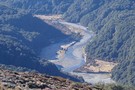
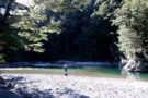
Lower Waipakihi Valley
GPX file
•
Distance: 6.4km away
The route down the lower Waipakihi just follows the river. You can cut off about 5 minutes at the point ...
More ▶︎
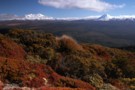
Mangahouhounui Stream
Photograph
•
Distance: 6.5km away
Looking down into the Mangahouhounui Stream
More ▶︎
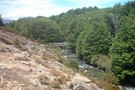
Lower Waipakahi Valley
Track
•
1 – 2 days. Easy/medium. One way.
•
Distance: 6.5km away
A nice easy valley with very pleasant camping all the way along its length
More ▶︎
Waihohonu Bridge - Round The Mountain (Ruapehu)
Photograph
•
Distance: 6.7km away
Bridge near Waihohonu Hut - ideal area for lunch
More ▶︎
Round the Mountain: Ruapehu
Track
•
5 days. Easy/medium. Loop track.
•
Distance: 6.7km away
Combined with part of the Tongariro Northern Circuit, this track forms a loop around Mt Ruapehu. Combined with the other ...
More ▶︎
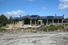
Waihohonu Hut
Hut
•
Great Walks Hut (DOC). Capacity: 28.
•
Distance: 6.7km away
The best hut on the Tongariro Northern Crossing. New flush! toilets. Three sleeping areas: one cosy room next to the ...
More ▶︎
Round The Mountain (Ruapheu)
GPX file
•
Distance: 6.7km away
Stage 1 Round The Mountain Track
More ▶︎

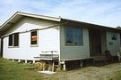
Waihohonu Hut
Photograph
•
Distance: 6.7km away
A typical lockwood Tongariro National Park Hut. It was supposed to be replaced but they have just built a new ...
More ▶︎
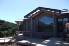
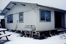
Waihohonu Hut
Photograph
•
Distance: 6.7km away
This is a new DOC hut on the Tongariro Northern Circuit completed late DEC 2010. It is about a 5min ...
More ▶︎
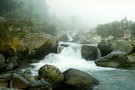
Mangahouhounui Stream
Photograph
•
Distance: 6.7km away
The Mangahouhounui Stream down where it entes the bush on a foggy morning
More ▶︎
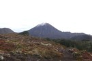
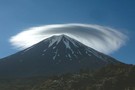
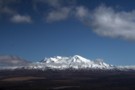
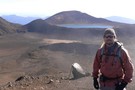
Mt Ngauruhoe - Tongariro Circuit
Photograph
•
Distance: 6.8km away
3 JUN 2011 - on the Tongariro circuit between Waihohonu and Oturere Huts. Approx 20min walk north of Waihohonu.
More ▶︎
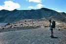
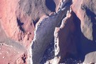
Lunarscape
Photograph
•
Distance: 6.8km away
It's a lunar like landscape that greets you after departing Oturere Hut for the Emerald Lakes.
Mount Ngarahoe offers a stunning ...
More ▶︎
Crossing the Waikato River
Photograph
•
Distance: 6.9km away
This smaller tributary of the Waipakihi is considered to be the official headwaters of the Waikato River. It is probably ...
More ▶︎
Old Waihohonu Hut
Photograph
•
Distance: 7.1km away
This historic hut is well worth the side trip on the Round The Mountain Track (Stage 1) (Ruapehu)
More ▶︎
Historic Waihohonu Hut
Hut
•
Standard Hut (DOC).
•
Distance: 7.3km away
This original Waihohonu hut was constructed in 1904 and is now a historic building with no accommodation. You can stay ...
More ▶︎
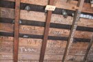
Old Waihohonu Hut graffiti
Photograph
•
Distance: 7.3km away
The youth of today!!!......graffiti on the rafters go back to at least 1918. If you are in the hut take ...
More ▶︎
Urchin-Umukarikari
GPX file
•
Distance: 7.9km away
This is a new track, it has only just been cut through the bush between Urchin and Umukarikari. It is ...
More ▶︎
Waipakihi Thunderbolt Loop
GPX file
•
Distance: 7.9km away
A 3 day loop in the Kaimanawas with a lot of enjoyable tops travel
More ▶︎
Urchin - Waipakihi Hut - Umukarikari - GPX
GPX file
•
Distance: 7.9km away
A GPX file of this classic trip
More ▶︎
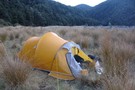
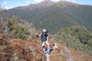
on the ridge
Photograph
•
Distance: 8.0km away
Photograph was taken in the late afternoon while slowly approaching Waipakihi hut in the valley.
More ▶︎
Urchin - Waipakihi Hut - Umukarikari Trip
Track
•
2 – 3 days. Easy/medium. Loop track with a road section.
•
Distance: 8.0km away
A classic 2 - 3 day trip in the Kaimanawas. Includes open tops, river travel and a comfy hut for ...
More ▶︎
Urchin-Umukarikari Loop Track
Track
•
1 – 2 days. Medium. Loop track with a road section.
•
Distance: 8.0km away
This is a new track linking the existing Umukarikari Track that goes to Waipakihi Hut with the Urchin Track that ...
More ▶︎
Waipakihi Thunderbolt Loop
Track
•
3 days. Medium. Loop track with a road section.
•
Distance: 8.0km away
A 3 day trip in the Kaimanawas following the Middle Range and enjoyable tops tramping. Also a probable night camping ...
More ▶︎
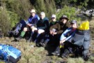
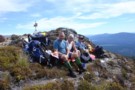
Happy Trampers in the Waipakihi
Photograph
•
Distance: 8.1km away
I sent this photo to the local newspaper and they published it
More ▶︎
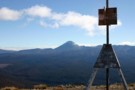
Urchin Trig
Photograph
•
Distance: 8.4km away
The trig on Urchin, a clear day back to Ngaruahoe
More ▶︎
Buggered
Photograph
•
Distance: 8.4km away
My mate on a hot day top of the climb onto Urchin from Waipakihi. Im with pmcke there isnt a ...
More ▶︎
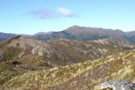
Kaimanawa Tops
Photograph
•
Distance: 8.4km away
First trip up on the tops, very taken with the vista!
More ▶︎
Lunch on Urchin Trig
Photograph
•
Distance: 8.4km away
Which ever way the wind is coming from dictates where you sit to have lunch on the Urchin. On this ...
More ▶︎
Scale of the Waipakihi
Photograph
•
Distance: 8.8km away
Morning sun making makes bright light on the Waipakihi
More ▶︎
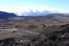
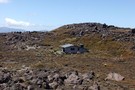
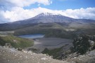
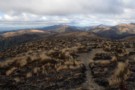
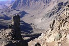
Oturere Valley
Photograph
•
Distance: 8.8km away
The Oturere Valley above Oturere Hut is a unique place. A real moonscape sculptured by lava flows
More ▶︎
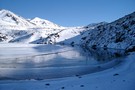
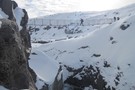
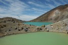
Emerald Lake - Winter
Photograph
•
Distance: 9.3km away
The lower Emerald Lake in its winter coat - taken June 2009. The track from Oturere Hut joins the Tongariro ...
More ▶︎
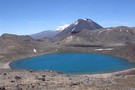
Blue Lake Panorama
Photograph
•
Distance: 9.4km away
Mt Ngauruhoe, Red Crater, Mt Tongariro, my wife Helen, Blue Lake.
We're all walking on the moon.
More ▶︎
Emerald Lakes, Tongariro crossing
Photograph
•
Distance: 9.5km away
Very rare image of the Lakes with no tourists in shot (I got lucky)
More ▶︎
On top of Urchin
Photograph
•
Distance: 9.6km away
Travelling along the tops from Urchin to the Waipakihi and you get great views of Tongariro National Park
More ▶︎

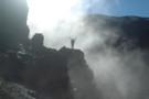
Into the wild
Photograph
•
Distance: 9.6km away
After the aptly named Devils staircase. A rewarding stretch in the clouds. Perhaps this could be renamed the stairway to ...
More ▶︎
Sunrise over Red Crater and the Blue Lake
Photograph
•
Distance: 9.6km away
From the top of Ngauruhoe, sunrise spreads it's light across the familiar but deserted landscape of tongariro.
More ▶︎

Tongariro Alpine Crossing
Track
•
1 day. Medium. One way.
•
Distance: 9.6km away
A popular but crowded alpine route through a spectacular volcanic landscape.
More ▶︎
Rim of Red Crater
Photograph
•
Distance: 9.6km away
Standing on the rim of Red Crater at the summit, Blue Lake in the background.
More ▶︎
Below Red Crater
Photograph
•
Distance: 9.6km away
View from the rim of South Crater, below Red Crater
More ▶︎
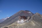
Ruapehu, Ngauruhoe, and Red Crater
Photograph
•
Distance: 9.8km away
These volcanoes and vents line up along the axis of the Taupo Volcanic Zone, a line of geothermal activity leading ...
More ▶︎
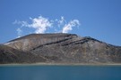
Blue Lake, Mount Tongariro
Photograph
•
Distance: 9.8km away
This lake occupies a crater next to the popular Tongariro Crossing track.
More ▶︎
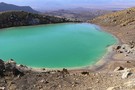
Emerald Lakes
Photograph
•
Distance: 9.8km away
Emerald lake viewed from the descent from Red Crater.
More ▶︎
Line up of Volcanos
Photograph
•
Distance: 9.9km away
This is one of the best places in Tongariro National Park to get a photo. All in a line, Blue ...
More ▶︎
Sulphur Lagoon
Photograph
•
Distance: 9.9km away
One of the Te Mari Craters on the northern flank of Tongariro, near Ketetahi Hut.
More ▶︎