Nearby
Scotts Saddle Track
Pudding Hill Stream Route
Track
•
1 day. Medium. One way.
•
Distance: less than 100m away
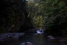
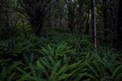
Unmarked route along Pudding Hill Stream in Mount Hutt Forest. Combine this route with the Scotts Saddle Track for an ...
More ▶︎
Pudding Hill Stream Route
Photograph
•
Distance: 312m away
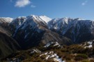
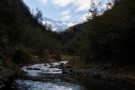
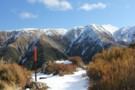
Setting off from Scott's Saddle, poles lead down 400 metres to the stream below. Point 1751 is across the valley.
More ▶︎

Alder Track / Ridge Track / Scotts Saddle Track circuit
Track
•
Easy/medium. Loop track.
•
Distance: 1.0km away
A loop track in forest at the foot of Mount Hutt. Several variations are available.
More ▶︎
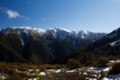
Pudding Hill Range
Photograph
•
Distance: 1.4km away
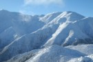
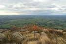
Looking up to point 1603, from Scott's Track. August 2014.
More ▶︎
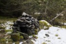
Stone fireplace
Photograph
•
Distance: 2.1km away
Tucked away at the back of some river flats on Pudding Hill Stream.
More ▶︎
Scott's Saddle
Photograph
•
Distance: 2.4km away
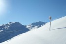
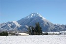
Top of the Scott's Saddle Track on Mount Hutt, looking toward the Pudding Hill Range.
More ▶︎
Mt Alford
Track
•
0 – 1 day. Easy/medium. Return by the same track.
•
Distance: 5.5km away
A walk through beech forest, open farmland and alpine scrub with great views of Mt Somers, Mt Winterslow and Mt ...
More ▶︎
Hakatere Conservation Park
Place
•
Conservation Park. 600.00km2.
•
Distance: 6.8km away
This park protects high country between the Rakaia and Rangitata Rivers in the Ashburton Lakes District, Mid-Canterbury.
More ▶︎
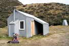
Cookies Hut
Hut
•
Standard Hut (DOC). Capacity: 6.
•
Distance: 9.3km away
Former musterers' hut oft used by hunters. Now owned and newly renovated by DoC as of Feb 2016.
More ▶︎
Comyns Cookies travels
Photograph
•
Distance: 9.4km away
Various routes around these huts and A-Frame hut.
More ▶︎
Rakaia Gorge Walkway
Track
•
Easy. Return via same track.
•
Distance: 9.9km away
Following the edge of the Rakaia Gorge, this track crosses volcanic lava flows and provides panoramic views of the river ...
More ▶︎