Nearby
Near Broken River Hut
Broken River Hut via Cave Stream
GPX file
•
Distance: 307m away
Alternative route to Broken River Hut. Land owners' permission needed.
More ▶︎
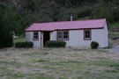
Broken River Hut
Hut
•
Basic Hut/Bivvy (DOC). Capacity: 4.
•
Distance: 308m away
Located upstream of Avoca Homestead.
More ▶︎
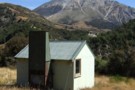
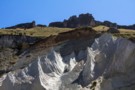
Broken River Hut
Photograph
•
Distance: 316m away
This little hut sits on a sunny terrace and a coal seam. The layers exposed here are part of the ...
More ▶︎
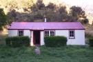
Broken River hut Feb 2012
Photograph
•
Distance: 323m away
This 1960 vintage NZFS 4 bunker is about 1.5hrs upstream from the Avoca Homestead hut. There are various coal mining ...
More ▶︎
Avoca Homestead
Hut
•
Standard Hut (DOC). Capacity: 6.
•
Distance: 4.3km away
This hut is the restored homestead of the Avoca Run, at the junction of Broken River and Slovens Stream (not ...
More ▶︎
Korowai/Torlesse Tussocklands Park
Place
•
Conservation Park. 210.00km2.
•
Distance: 5.6km away
This park incorporates the Torlesse and Big Ben Ranges either side of Porter's Pass. The Torlesse Gap is a prominent ...
More ▶︎
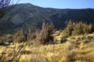
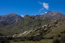
Bold Hill
Photograph
•
Distance: 5.6km away
Looking at the North face of Bold Hill from the terraces above Broken River.
More ▶︎
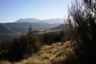
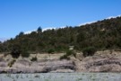
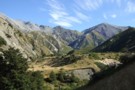
Craigieburn Valley
Photograph
•
Distance: 5.6km away
View North from the terrace above Avoca homestead
More ▶︎
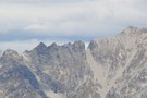
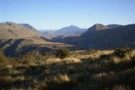
View of Torlesse Gap from the west
Photograph
•
Distance: 6.0km away
The well recognised landmark on the Torlesse Range can easily be seen from the top of Broken Hill in the ...
More ▶︎
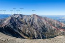
Prebble Hill (902m)
Photograph
•
Distance: 6.9km away
Red Peak (1853m), The Gap, and Castle Hill Peak (1998m) behind.
More ▶︎
Mt Torlesse
Track
•
1 day. Easy/medium. Return by the same track.
•
Distance: 7.1km away
Noteworthy peak east of Porters Pass.
More ▶︎
Castle Hill
Photograph
•
Distance: 7.3km away
not much of a tramp, but worth a look. Flock hill.
More ▶︎
Torlesse Range Feb 2014
Photograph
•
Distance: 8.1km away
This photo is taken from slightly uphill of & beside the John Hayward Memorial Hut (Kowai Hut) in the Kowai ...
More ▶︎
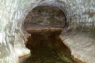
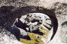
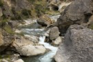
Cave Stream
Track
•
Medium. One way (about 5 mins walk from end to end).
•
Distance: 8.6km away
An exciting walk through a twisty limestone cave near Castle Hill.
More ▶︎
Kowai/Castle Hill Peak/Porters Pass Circuit
Article
•
Distance: 9.0km away
Circuit of the above. Can be done as a day trip or in our case, 2 days broken by a ...
More ▶︎
Castle Hill Peak
GPX file
•
Distance: 9.2km away
Straightforward alpine walk with great views.
More ▶︎
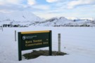
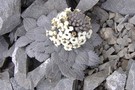
DOC sign
Photograph
•
Distance: 9.3km away
Kura Tawhiti Conservation Area is the karst landscape also known as Castle Hill, located on the road between Porter's and ...
More ▶︎
Walker Hut
Hut
•
Basic Hut/Bivvy (DOC).
•
Distance: 9.5km away
Hut on the Waimakariri Gorge near Broken River, part of Oxford Forest Conservation Area.
More ▶︎
Helicopter Hill Circuit
Track
•
Easy/medium. Loop track.
•
Distance: 9.6km away
This circuit in Craigieburn Forest Park knits together several different tracks, and visits the summit of Helicopter Hill (1256m).
More ▶︎
Craigieburn Shelter campsite
Campsite
•
Basic Campsite (DOC). 20 spaces.
•
Distance: 9.7km away
Popular campsite on the banks of Cave Stream in Craigieburn Forest Park, with a number of easy walking tracks nearby. ...
More ▶︎