Nearby
Jubilee hut via Devils staircase
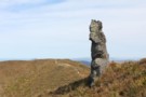
Schist tor
Photograph
•
Distance: 771m away
This unlikely outcrop is near the track just below Silver Peak (767m).
More ▶︎
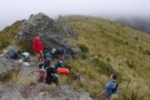
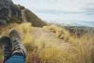
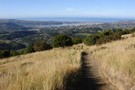
Lunch on the top of Silver Peak
Photograph
•
Distance: 1.0km away
This is the highest point in the Silver Peaks (777m). It was nice enough to stop here for lunch but ...
More ▶︎
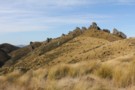
Silver Peaks
Place
•
Reserve.
•
Distance: 1.0km away
A tramping area not far from Dunedin, only rising to 777m at it's highest point. But is well known for ...
More ▶︎
Silver Peaks-Jubilee Hut
Track
•
1 – 2 days. Easy/medium. One way.
•
Distance: 1.4km away
This is probably the easiest way to get to Jubilee Hut from Dunedin. There is a shorter route up Christmas ...
More ▶︎
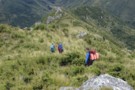
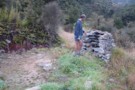
Descending the Devil's Staircase
Photograph
•
Distance: 1.5km away
The route from the tops down to Jubilee Hut is known as the Devil's Staircase
More ▶︎
Silver Peaks Route
Track
•
1 day. Medium. One way.
•
Distance: 2.9km away
Route in the Silver Peaks range from Jubliee Hut to Mountain Road via ABC Cave and Philip J Cox Memorial ...
More ▶︎
Silver Peaks Route: Jubilee Hut to ABC Cave
GPX file
•
Distance: 2.9km away
Section of the Silver Peaks Route.
More ▶︎
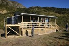
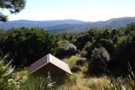
Jubilee Hut
Hut
•
Standard Hut (DOC). Capacity: 10.
•
Distance: 2.9km away
A brand new hut built by DOC in the Silver Peaks to replace the old hut that was built for ...
More ▶︎
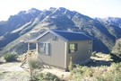
Jubilee Hut
Photograph
•
Distance: 2.9km away
Taken by Anthony Pettinger on the opening of the new Jubilee Hut
More ▶︎
Jubilee Hut
Photograph
•
Distance: 2.9km away
Taken by Anthony Pettinger at the opening of the new Jubilee Hut
More ▶︎
The Old Jubilee Hut site
Photograph
•
Distance: 3.1km away
The old Jubilee Hut was on this site, built in 1948 to commemorate the 25th Jubilee of the Otagao Tramping ...
More ▶︎
Silver Peaks Route: ABC Cave to Philip J Cox Memorial Hut
GPX file
•
Distance: 4.2km away
Section of the Silver Peaks Route.
More ▶︎
Tors near ABC Cave
Photograph
•
Distance: 4.2km away
Schist tors like a row of shark teeth. The cave is down in the valley to the left.
More ▶︎
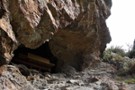
ABC Cave
Rock bivouac
•
Distance: 4.8km away
Fitted out with a sleeping platform, this cave is named after Al, Bruce, and Colin, three young men from Dunedin. ...
More ▶︎
ABC Cave
Photograph
•
Distance: 4.8km away
A snug cave with a sleeping platform in Dunedin's Silver Peaks Range.
More ▶︎
Silver Peakery boots
Photograph
•
Distance: 4.9km away
Up near The Gap in the Silver Peaks, my boots got tired.
Tired of being so rubbery.
And smelly to boot.
More ▶︎
Silver Peaks Route: Philip J Cox Memorial Hut to Mountain Road
GPX file
•
Distance: 5.0km away
Final section of the Silver Peaks Route.
More ▶︎
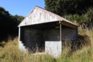
Philip J Cox Memorial Hut
Hut
•
Standard Hut (DOC). Capacity: 4.
•
Distance: 5.0km away
Hut on the Silver Peaks Route.
More ▶︎
Yellow Hut
Hut
•
Basic Hut/Bivvy (DOC).
•
Distance: 5.1km away
Dirt floor and no bunks. Planned for removal.
More ▶︎
Ben Rudd's Shelter
Hut
•
Shelter (PVT).
•
Distance: 9.2km away
Owned by the Otago Tramping and Mountaineering Club this shelter is on a 44ha property owned by the club.
More ▶︎
Ben Rudd's Shelter
Photograph
•
Distance: 9.2km away
A picnic shelter only, no bunks or facilities but a good view of the Silver Peaks from the Linda Mercier ...
More ▶︎
Pineapple Track- Skyline Walk GPX
GPX file
•
Distance: 9.2km away
A GPX file of this popular walk
More ▶︎
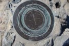
Flagstaff Plane Table
Photograph
•
Distance: 9.9km away
The plane table on the top of Flagstaff
More ▶︎
Pineapple Track - Skyline Walkway
Track
•
Easy. One way.
•
Distance: 9.9km away
This is an easy and popular track that gives great views of Dunedin city
More ▶︎
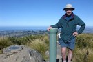
Flagstaff Summit
Photograph
•
Distance: 9.9km away
From the Summit of Flagstaff you get a 360 degree view of the Dunedin area
More ▶︎