Mount Alexander
- 2 days return via same track
- Medium
The route starts approximately 19 km south of Moana (towards Chch) on the Inchbonnie-Rotomanu Road, just north of Lake Poerua.
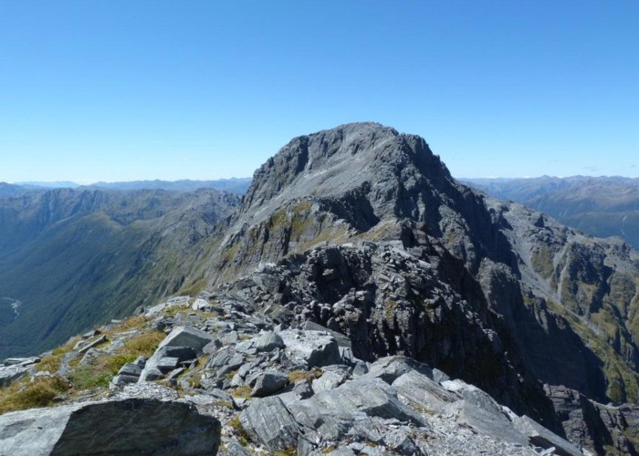
From the road-end the route passes through thick rain forest until it reaches Camp Creek. It then continues up the creek bed until climbing steeply up a side creek and then a ridge until levelling out and sidling around the hill, high above the creek. The route crosses the creek shortly before reaching Camp Creek Hut (up a short side-track) and then climbs very steeply onto the tops and a long ridge leading to the summit of Mt Alexander. Spectacular 360 degree views reward the tramper after a long and steep climb.
2 members favourited
4 members checked in
|
Walking time
|
2 days
6 hr – 10 hr
|
|---|---|
|
Distance
|
8.0km |
|
Type
|
Return via same track
|
|
Grade
|
Medium |
|
Bookings
|
No bookings — open access
No — open access
|
|
Starts
|
The route starts approximately 19 km south of Moana (towards Chch) on the Inchbonnie-Rotomanu Road, just north of Lake Poerua. |
|---|---|
|
Maps
|
NZTopo50-BU20
|
|
Altitude
|
170m
–
1,958m
Altitude change 1,788m
|
|
Link
|
www.doc.govt.nz/parks-and-recreation/tracks-and-walks/west-coast/greymouth/greymouth-backcountry-routes/http://www.doc.govt.nz/parks-and-recreation/tracks-and-walks/west-coast/greymouth/greymouth-backcountry-routes/ |
|---|