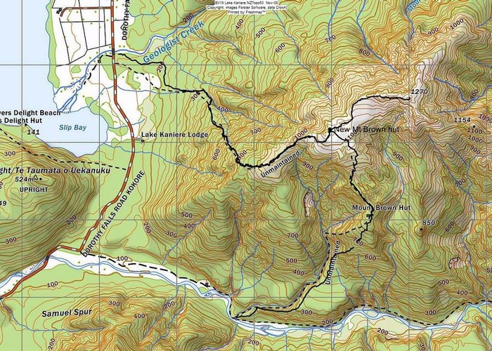
Mt Brown summit & circuit routes March 2011

This map shows the actual track/routes overlayed in solid black lines on a Topo 50 map. The "old" Mt Brown hut has been removed and the unmaintained track comments can be ignored as the tracks have been tidied up by volunteers. The recently changed course of the Styx River does not pose a problem at normal flows in accessing by foot the Styx end of the track.
A nice little trip is to head up to the "New" Mt Brown hut by either the Geologists Creek or Styx routes, drop your packs there then do an ascent of Brown & return to the hut. The descent from the hut can be by the route not used on the way up. Most parties would want to include a night at the nice new hut as part of a circuit trip & climb of Mt Brown but a fit party could comfortably fit it all into a day trip. Allow 2 - 4 hrs to walk up to the hut from either the GC carpark or the new carpark at the Styx gate & signs. From the hut up to the top of Mt Brown takes 30 - 60 mins. [It is a 30 min walk betw car parks]
Comments
-
 glennj This morning I gps'd the tracks whilst doing a recce & a little silky saw work. A gpx file of the tracks has now been uploaded to this site.
23 December 2011
 -
 glennj Hello Bernie, Yes that solid line was plotted with a GPS. I did it to see the relationship of the new bits of track to the old track. No I didn't upload a gpx file. The map above is a JPG screen save of the GPS plot of the current tracks superimposed on the Topo50 map "Freshmap" digital version. I no longer have the track data saved just the waypoint of the hut location so I can't supply a gpx of the tracks at the moment. I could easily plot it again as my average visit frequency for Mt Brown is about every six weeks. Are you considering a trip to the area?
4 June 2011
 -
 bernieq Glenn, the map plot looks like it came from a gps - did you upload a gpx file to this site?
3 June 2011
 -
 glennj Yes the bit of the original track we re- cut below the "old" hut site was quite overgrown & some old yellow tapes were off line making it confusing before the re cut. It was Alan Jemison who came up with the idea of rerouting the section from just below the "old" hut site down to the Styx. He heard from a hunter that there was a better route and did a recce, agreed & marked a rough line. I just helped Alan get it cut & marked when he wanted a hand regardless of having projects of my own on the go.
15 March 2011
 -
 Honora Thanks for the plotting of your new track, Glenn. The old track down to the creek is still a challenge to follow! I'm sure there were some old permolats placed where no one has been for a long time. Frank placed multiple orange cruise tape where the old track starts in the "Mt Brown" creek just downstream of the waterfall. This track hasn't had any cutting for many years and the line of cruise tape is very inconsistent.
14 March 2011