Wilkin Valley Track
- 2 – 5 days return via same track
- Easy/medium
This stunning track is commonly tramped in cunjunction with the Gillespie Pass Circuit or with the Rabbit Pass/East Matukituki traverse, but makes a great long weekend trip all by itself. The Wilkins has plenty of options for those wishing a longer trip with several untracked side valleys to explore. Highlight of the track are the three lakes Dianna, Lucidus and Castalia, located up the North branch past Top Forks hut. The Wilkins track starts at the Makarora/Wilkin river confluence with a fording of the unbridged Makarora required. Jetboats operate on the rivers and can drop parties off halfway up at Kerin Forks saving about 8 hours of walking. The track past Kerin Forks is on the true right side of the river and can be impossible to reach if the river is up. It is possible to go up the true left but the going is difficult and slow.
|
Walking time
|
2 – 5 days |
|---|---|
|
Type
|
Return via same track
|
|
Grade
|
Easy/medium |
|
Bookings
|
No bookings — open access
No — open access
|
|
Starts
|
About 3km South of Makarora township, or at Kerin Forks if coming from the Gillespie Pass Circuit. |
|---|---|
|
Ends
|
Makarora township |
|
Maps
|
NZTopo50-BZ11
NZTopo50-BZ12 |
|
Altitude
|
300m
–
1,120m
Altitude change 820m
|
The Jetboats from Makarora to Kerin Forks are the easiest way to get across the Makarora and save hours of uninteresting walking up the lower Wilkin through farmland, riverflats and forest, plus remove the potentially difficult fording of the Wilkin itself. A good ford over the Wilkin does exist at Dans Flat for those walking up. Makarora to Kerin Forks hut about 6-8 hours on foot or about 20 minutes in the jetboat.
Parties ariving in the Wilkin from the Gillespie Pass Circuit need to ford the Wilkins at Kerin Forks and may need to get the jetboat across. If you choose to go up the true left bare in mind that you will have to cross the Siberia, Newland and Wonderland streams which will be very difficult in flood. From Kerin Forks to Jumboland Flats via the true left about 8 hours.
From Kerin Forks the marked track goes up the true right of the Wilkins through beech forest and is in good condition allowing swift travel. The large grassy flats at Jumboland is reached after about 2-3 hours with plenty of great camping spots. Its possible to ford the Wilkin here and follow the Wonderland stream to the Wonderland valley, also to climb Mt Jumbo from here. The track reenters the bush at the North end of the flats and climbs up a bit of a gorge before descending to the extensive Top Flats. The track markers essentially end here except for the occastional sporatic one, but it is a simple task to follow the true right river bank the whole way up the flats to Top Forks hut. There is one large bush covered hill which extends right down to the river at F38 834 507 and a marked track climbs and descends steeply over it, but if the river is low it is far easier to ford the Wilkins to the true left and then cross back when past the hill. Top Forks hut is located up on a rise a short distance further on. Kerin Forks hut to Top Forks hut about 4-5 hours.
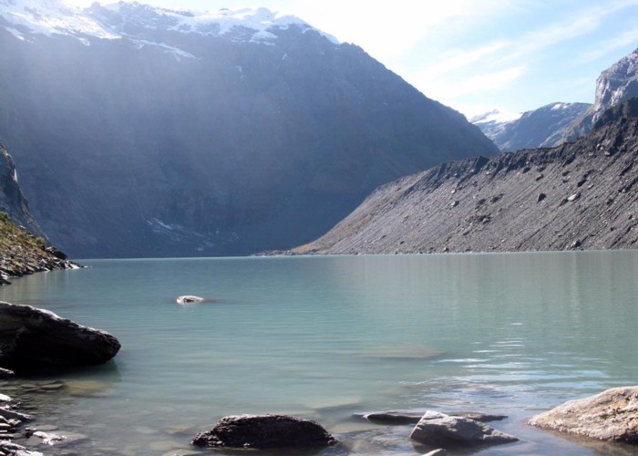
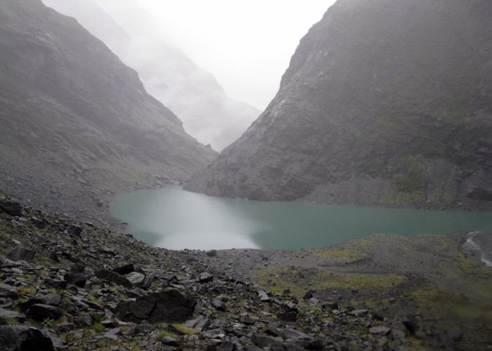
From Top Forks the South branch of the Wilkins takes you to Rabbit Pass and the East Matukituki valley via the infamous Waterfall face. The track to the North branch lakes fords the South branch and then heads North on the Wilkins true right. A large side stream has to be crossed and then the track climbs steeply up a gorge before leveling off. After a short while a small lake called The Dissapearing Tarn is reached with gorgeous reflections of the surrounding mountains on a still day. Shortly after this the bushline is cleared and Lake Dianna is visible a short scamble off the track through grass and scrub to the left. Continuing up valley will reveal to you a massive morain wall which forms Lake Lucidus. A junction in the track is reached and heading North takes you up to the outlet of Lucidus. For a simply stunning view, ford the outlet stream and climb the tall South morain hill. Its a bit of a slog to get up there but the view up Lucidus or South down the valley is amazing. Dont bother trying to climb the East morain as the rocks are slippery, the scrub dense and boulder holes numerous. Once back down at the track junction, the track fords the Wilkins and continue North to the East of Lucidus. It undulates a bit and near the top of the moraine wall the Wilkins is crossed again then recrossed higher up. The last stretch to Lake Castalia is done on the true left and is a scramble up loose rock through a gorge. You emerge at the outlet for Castalia. For the adventurous its possible to carry on round the Eastern side of the lake, and Moirs guide refers to a route up the steep Eastern rock walls to head North along the tops to the Te Naihi river. Top Forks hut to Lake Diana about an hour, Dianna to Lucidus about 30 minutes, Lucidus to Castalia about an hour. Castalia back to Top Forks about 2 hours.