Thompson's Track to Kauritatahi Track
Kaimai-Mamaku Forest Park
- 1 – 2 days return via same track
- Medium
From a very muddy Thompson's Track to an overgrown North South Track, this can't be described as the greatest of tracks. But the hut is a pleasant one with a great view. A side trip will take you to the site of New Zealand's worst aviation disaster.
|
Walking time
|
1 – 2 days
8 hr – 12 hr
|
|---|---|
|
Distance
|
18.5km |
|
Type
|
Return via same track
|
|
Grade
|
Medium |
|
Bookings
|
No bookings — open access
No — open access
|
|
Starts
|
Thompson's Track |
|---|---|
|
Maps
|
NZTopo50-BD36
NZTopo50-BD35 |
|
Altitude
|
250m
–
825m
Altitude change 575m
|
Thompson’s Track is not only the name of the track that crosses the Kaimais, it is also the name of the road when it leaves State Highway 2 between Tauranga and Katikati.
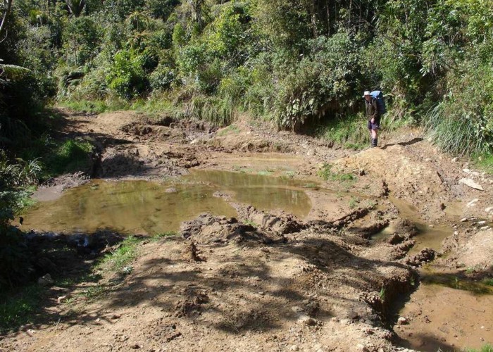
At the end of the 5-km road it turns into a muddy nightmare. Thompson’s Track is less of a tramping delight than a 4-wheel driver and motorcyclists paradise. My suggestion is to get an early start up here and you should get to the top before the traffic begins. I also suggest that you get off the track promptly when you hear motorbikes. Some of them go at great speed.
Just past the last stream before you get to the top there is a shortcut, which leads you onto the North-South Track. It is overgrown and only occasionally marked by old red permolats. It is very difficult to find going up so it may be easier to go right to the top of the range and pick up the North South Track there.
Once atop Thompson's Track, head south along the range. Begin by ascending the 4WD tracks, to where the orange markers lead you into the bush on your left. There's half a dunny here in the scrub if you look around.
At the point where the shortcut and the North South track meet there is a small grassy clearing which makes a reasonable camping site. Water is a little distance away but apart from that it is always sheltered here right on top of the range. The wind just blows right across above you. There is also the remains of a hut here. The steps can be seen in a thick bush. The old long drop toilet is still there and quite usable.
From here continue south along a well-marked track for about 15 mins before you come across the junction where the new North South track heads down the eastern side of the range and the old track continues up. This point is now well marked so you won’t miss it. There is water on the new NS Track 5 mins past this point if you are camping back at the clearing.
The old track is now very overgrown and is no longer maintained by DOC. However it is marked by permolats and can be followed with care. It sidles up on the eastern side of Mt Ngatamahinerua climbing at a fairly constant rate. Once you leave the bush there are good views of the Bay of Plenty and the Katikati area.
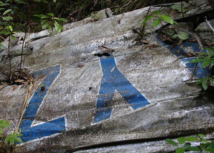
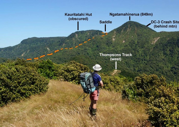
When the track reaches the ridgeline again you pass a tree with a bit of pink paint on it on your right. There is a rough track that leaves here, climbs up to a big, blackened dead tree, and then crosses a slip on the western side of the range. You can go down here about 150m to visit the site of the crash of ZK-AYZ. This is the site of New Zealand’s worst aviation disaster on 3 July 1963. 23 people died here when a Douglas DC-3 airliner slammed into the range in a storm. The wing of the airliner can still be seen in the gully with its registration still clearly visible. There is also a lot of debris around plus a plaque that was placed there on the 40th anniversary of the crash in 2003.
If visiting this site please do so with some reverence. 23 people died here and some of the bodies were not recovered. It is a peaceful place with the only sound being the trickle of a stream. On one visit recently the rata was blooming profusely. Please be respectful and do not souvenir.
When descending to the crash site, keep to the true left of the stream as it becomes deeply incised. The wing is down a deep gully and a rope may be helpful if you want to go right down to it. Many parties have not been able to locate the wreckage at all.
To get to Kauritatahi Hut, from the pink tree, continue along the small saddle. Three minutes on there's a tricky rock face to clamber up - not safe for children! The track continues to climb and sidle until it reaches the crest of the range once again. This time the top of the range is more plateau-like and the track is wet and poorly drained, which is why DOC rerouted it.
40 minutes from the pink tree, you might spot the hut roof ahead to the left. Continue past the hut until you come across a sign. The track to the left leads directly to the hut, after only a couple of minutes.
The hut has recently been upgraded by the local branch of NZDA and is in good condition. It has great views over Katikati and the sunrises are reputed to be supurb. There are 3 bunks in it, plus a true piece of Kiwi ingenuity in the form of a pull-down hammock. Water tank is functioning and there's great cell-phone reception.