Abel Tasman Coast Track
Abel Tasman National Park
- 3 – 5 days one way
- Easy
- Bookings required
- Marahau to Anchorage: 12.4km, 4 hours
- Anchorage to Bark Bay
- High tide track: 12.1km, 4 hours
- Estuary crossing, 2 hours either side of low tide: 8.4km, 3 hours
- Bark Bay to Awaroa Inlet:11.4km, 4 hours
- Awaroa Inlet to Whariwharangi Bay: 13.8km, 4 hours 45 minutes
- Whariwharangi Bay to Wainui Bay: 5.5km, 1 hour 30 minutes
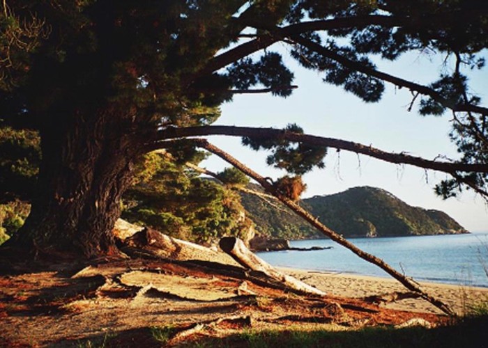
Easy, sunny coastal track with golden sands and excellent swimming. This, the busiest track in the country follows, the full length of the small park's beautiful coastline.
|
Walking time
|
3 – 5 days
17 hr 15 min – 18 hr 15 min
|
|---|---|
|
Distance
|
54.4km |
|
Type
|
One way
|
|
Grade
|
Easy |
|
Bookings
|
Bookings required
Required
Huts and campsites must be booked all year around. See the link below.
|
|
Starts
|
Marahau River, Abel Tasman National Park |
|---|---|
|
Ends
|
Wainui Bay |
|
Maps
|
NZTopo50-BN25
NZTopo50-BP25 |
|
Altitude
|
Sea level |
|
Link
|
www.doc.govt.nz/parks-and-recreation/tracks-and-walks/nelson-tasman/golden-bay/abel-tasman-coast-track/http://www.doc.govt.nz/parks-and-recreation/tracks-and-walks/nelson-tasman/golden-bay/abel-tasman-coast-track/ |
|---|
Options for walking are very flexible with boat access to most points on the track and vehicle access at Marahau, Wainui Bay, Awaroa Inlet, and Totaranui. Many people only walk the Marahau-Totaranui section, while others arrange to be dropped off and picked up by boat, and don't walk anywhere at all! Both ends connect with the Abel Tasman Inland Track, making an excellent (although more challenging) circuit of the park possible. It is also possible to walk an easy section of the Inland Track to return from Wainui Bay to Totaranui, if desired. Huts can become very full during summer so camping may be a wise choice.
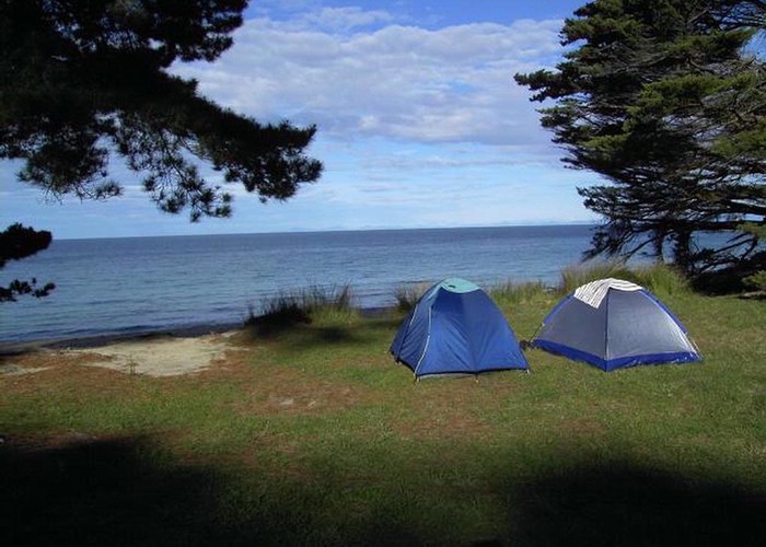
As one of the Great Walks, hut or campsite passes specific to the track must be purchased prior to setting out. Hut passes do not guarantee a sleeping space, and there is a two night limit on stay at each hut. Camping is only allowed at specified campsites. Passes may be purchased from visitor centres and DOC offices as well as outdoor shops, hostels and other outlets in the Nelson region. The Totaranui Campground is not part of the Great Walk. Bookings are required to camp there between December 20 and January 31. These are issued by DOC Takaka. Great Walks Campsites are located along the track, of which 17 are located away from huts. Each campsite provides water and a toilet.
Marahau to Anchorage
Crossing the estuary of the Marahau River, the track winds along the coastline, passing the end of the Inland Track. The Coastal Track turns briefly inland before dropping to Anchorage Bay. 7 campsites are passed during this section before the hut.
Anchorage to Bark Bay
Torrent Bay Lagoon can be crossed 2 hrs either side of low tide. Otherwise a track follows the shoreline. Soon the Falls River is passed before the track drops back to the sea. There are 4 campsites along this section.
Bark Bay to Awaroa Inlet
Crossing the estuary or following the all-tide track, the track climbs away from the sea and crosses a saddle before returning to the shoreline by an old granite quarry. This stretch of coastline borders the Tonga Island Marine Reserve. The track soon crosses Tonga Saddle over to the Awaroa Inlet. There are 3 campsites along this section.
Awaroa Inlet to Totaranui Campground
The Awaroa estuary must be crossed 2 hrs either side of low tide. Beyond Goat Bay is a lookout at Skinner Point and a descent into Totaranui. There is 1 campsite along this section near Goat Bay.
Totaranui Campground to Whariwharangi Bay
Edging around Totaranui estuary a track leads off to the left meeting the Inland Track and providing alternative access to or from Wainui Bay. The Coastal Track crosses a saddle to Anapai Bay and Mutton Cove, both of which have campsites. Another saddle with a side trip to Separation Point leads to Whariwharangi Bay and its restored farm homestead.
Whariwharangi Bay to Wainui Bay
A saddle provides views of Wainui Inlet before dropping through gorse to the car park.