
10 - 12th November, 2023

I was dead keen to do this trip when I saw it on the PTC program. What made it even better was the team that signed up for it. Frank had warned me off attempting to travel in Pell Stream during the winter so the timing was ideal with no wasps either. I'd spent so much time researching the weather and previous write-ups of this trip, I forgot to ensure I knew where the track to Mt Mueller actually starts! We had a fair idea and parked at a layby not far from the sign indicating a picnic area.
We unloaded Helen's 'truck' and she and I carried on to Marble Hill car park to leave it there. Then we managed to get a lift from the first car leaving the car park driven by a young woman who'd enjoyed L. Daniell with her pals. We'd only been gone for 15 minutes. Some of us softies crossed the Maruia in light footwear and others in their boots. We all searched for the start of the track and when I saw an exploration further downstream would mean wet boots I backed off and instead climbed up onto a low terrace and headed down valley from there for a few metres before I encountered the well-marked track. It must have started across from the genuine picnic area, not our layby.
For some reason I was elected to go in front and despite offers, it remained so for nearly all the trip. We followed the maintained track to the edge of a small stream and then had to cast about as we couldn't see markers. Eventually they were spotted and I augmented them with more cruise tape. We began the climb up to the bushline via a steep but clear and well-marked track up a sharp spur. Where it slackened off, we stopped for lunch in a mossy patch in sunlight.
When we got to the bushline we took another break to admire the view of the Maruia and the Lewis Tops then carried on in easily navigable scrub and tussock to the summit of Mt Mueller, noting a few small tarns en route. Helen was very pleased to arrive here as it had been in her sights for a while. However after this the ridgeline got very broken up and we had to take time and care. In hindsight, we may have been able to bypass the ridge. Frank had done it in the mist years before with the CTC and because they'd been going up, rather than down, it had given him no impression of awkwardness.
We'd decided to camp at a large tarn but there were 2 more rocky summits which we bypassed with a protracted sidle on the western side. Keith regained the ridge to check out the route to the tarn on the shaded side but we decided to continue the very pleasant sidle in sunshine to a notch 300m north of Pt 1613. Frank looked over the ridge just up from this notch and gave us the thumbs-up when he saw easy terrain and a little tarn adjacent to a small flat of short tussocks, ideal for a campsite. We pitched our 4 wee tents (just like the CTC!) and the others set to cooking themselves a communal meal whilst I cooked Frank's and mine in the shelter of a large boulder as our set-up doesn't use a windshield.
We were hoping for our eastern aspect to catch the morning sun but alas, we woke to a gentle patter. We finally formally rose at 8.30am and luckily the fine drizzle had stopped. Eventually the skies cleared and having packed our very wet tents with varying degrees of internal condensation to compare, off we went along a deeply etched historic deer trail. The terrain was very pleasant going. Keith suggested descending to the Pell via Pt 1163 and 985 and when Frank saw the bluff-free profile of this route he was very enthusiastic, even more so when we saw the strong deer trail heading down the defined spur which we approached after a spot of sidling.We stopped just short of the bushline in a sunny and sheltered spot for lunch. Just as well as the forest was bordered by a short section of very thick scrub we had to shove our way through. But after that, the deer trails persisted and there was very little undergrowth to contend with on our descent. I held my phone for the first time ever, continually, to navigate to ensure we stayed on the correct spurs but chewed through a bit of battery. Better to leave this task to Frank with his ever-on Garmin at hand.
At the dip between Pts 1163 and 985, we scouted for water to augment our supplies and climbed up over Pt 985 then traveled on a NE bearing to a final slight rise. Our route from here would be decided by the thickness of the vegetation. Fortunately the subcanopy remained open so we then crossed the side stream at the 800m contour and followed a bearing directly to meet up with the track which from memory skirted an old slip, just before its final descent to the Pell. Frank spotted a pink ribbon not far from our proposed intersection so we headed there and Keith led us down to Pell Stream via a well-marked and cleared track.
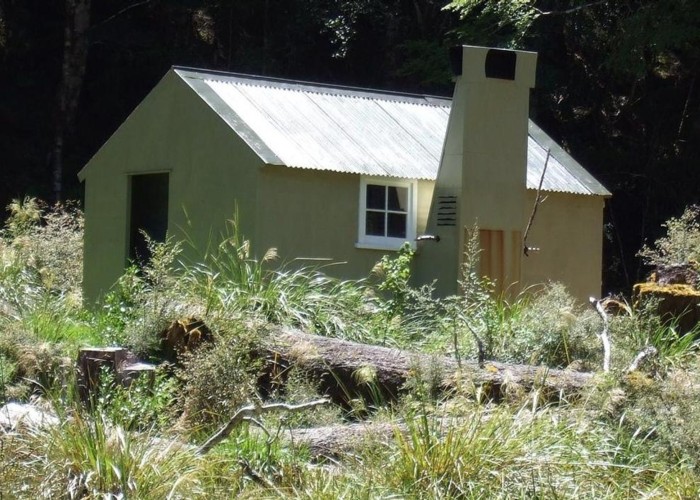
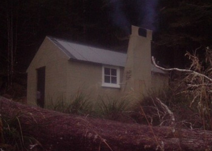
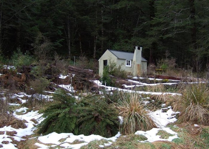
We cut through swampy grasses and a couple of patches of beech forest then saw the sunny terrace on the true right where the 4 bunk hut sits. We crossed and spent the rest of the afternoon drying out our tents etc. The hut was in good order with plenty of firewood but there was no need for that on this mild evening. Keith pitched his now-dry tent closer to the river at the edge of forest and we sat outside in the sun until it disappeared behind trees. Helen was keen for an early start the next morning as she had a long drive ahead to Ashburton after dropping us off at Peter's in Chch. She spotted a rifleman outside the hut window.
We read all the comments in the hut book on various routes down spurs from the Freyberg Range and the condition of the Pell Stream track. Lots of slips have broken the continuity of the original track, necessitating unmarked or subtly marked work-arounds. Basically the track runs completely on the true left but there are 2 crossings, one mandatory, onto the true right bank briefly. One of these could be done as a wade after traveling on a short rocky moss-covered section. I backtracked and put up markers across one slip that had had us splitting up into 2 groups to scout the route. At one point, I didn't have a clue and ended up climbing up through a deer trail and then having to lead the group down through forest back to the track. Someone needs to mark the correct route which stays down by the river!
We traveled through the very picturesque gorges and arrived via a well-established track at Gilchrist Stream for lunch in the sun. After crossing the stream, Peter lost one of his 9 lives with a tumble off the track leading miraculously to only a few abrasions and no apparent ill-effect though we nervously monitored him for signs of declining level of consciousness but he was his same old self throughout. Ironically the track got very easy and almost benched after Gilchrist and we were rewarded with 2 kaka flying around in the canopy, making an atypical bell-like call on one occasion.
We arrived at the 4WD track and with time-constraints were unable to bag Blackadder Rest, a goldminers hut, which sits down by Pell Stream. There was a bit of shilly-shallying about whether we should stick to the track and ford the Maruia or cross Alfred Stream and hoof it down to the carpark via the L. Daniells track. So we compromised by leaving the 4WD track and taking a side track to the river's edge, passing a big permanent goldminer's tent en route. Eventually we were forced to undergo a less than optimal crossing despite better fords upstream but it gave us the opportunity to link up to demonstrate care for each other.
The mushy 4WD track had exacerbated my tender toe and Frank's ankle so the L. Daniells track was much more pleasant travel. We got to the Sluice Box for a final photo finish then changed and drove back to Chch with my introducing some to the delights of mine host at the Culverden pub!
