Nearby
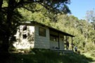
Upper Glenroy Hut [Removed]
Lake Daniels to Lake Rotoroa
GPX file
•
Distance: 3.9km away
Route tracing of Alternate route from the Lewis Pass to St Arnaud
More ▶︎
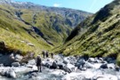
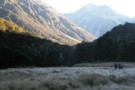
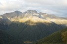
West Matakitaki Valley
Photograph
•
Distance: 3.9km away
traveling up the valley to 3 Tarns, it's easiest to keep to the river until the last push to the ...
More ▶︎
W Matakitaki - Ada Pass Hut
GPX file
•
Distance: 4.3km away
Treeline in West Matakitaki Valley to Ada Pass Hut, via 3 Tarns Pass
An actual, recorded, gpx – the only thing ...
More ▶︎
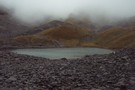
South side of 3 Tarns Pass
Photograph
•
Distance: 4.9km away
campsite and tarn as sunset approaches
Feb 2013
More ▶︎

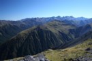
Profile : St Arnaud - Lewis Pass
Photograph
•
Distance: 4.9km away
A useful profile of the 100km tramp - with a couple of bad weather alternatives :
1. low route past Speargrass ...
More ▶︎

St Arnaud - Lewis Pass
Article
•
Distance: 4.9km away
A 9-day 100km tramp via the Thompson, D'Urville and 3 Tarns Passes
Feb 2013
More ▶︎
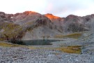
3 Tarns Pass
Photograph
•
Distance: 5.1km away
from the Pass, looking back to the 3 tarns
the better camping is on the south side of the pass
Feb 2013
More ▶︎
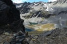
Three Tarns, Three Tarns Pass
Photograph
•
Distance: 5.2km away
Three Tarns, Three Tarns Pass - at the head of the West Matakitaki Valley
More ▶︎
Pell Stream
Track
•
2 – 3 days. Medium. Loop track with a road section.
•
Distance: 5.3km away
This highly recommended valley not far from the highway west of the Lewis pass, is accessible to most people with ...
More ▶︎
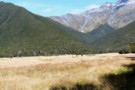
West Matakitaki valley
Photograph
•
Distance: 6.1km away
West Matakitaki valley, heading from Bob's Hut to Three Tarn Pass
More ▶︎
Picton to Aspiring
GPX file
•
Distance: 6.3km away
An aborted alpine traverse. Picton to West Cape, but aborted at Aspiring due to real world emergencies back home. Posted ...
More ▶︎
Lewis Pass National Reserve
Place
•
Reserve. 182.95km2.
•
Distance: 6.5km away
A small park occupying the forested valleys around Lewis Pass and bordering Lake Sumner and Victoria Forest Parks as well ...
More ▶︎
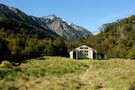
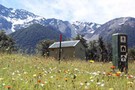
Ada Pass Hut
Hut
•
Serviced Hut (DOC). Capacity: 20.
•
Distance: 6.5km away
Ada Pass Hut (sleeps 14 on platform beds, matresses, stove, tank & river water) is a large, comfortable two-room hut ...
More ▶︎

Lake Thompson
Photograph
•
Distance: 6.5km away
A view of the beautiful Lake Thompson, a short distance from Thompson Pass
More ▶︎

Route Guide: St Arnaud to Lewis Pass
Article
•
Distance: 6.5km away
A 5-7 day north-south route from St Arnaud to the Lewis Pass, via Travers Pass, Waiau Pass, Thompson Pass and ...
More ▶︎

Cannibal Gorge, Ada Pass
Track
•
2 days. Easy. Return via same track.
•
Distance: 6.5km away
An easy overnighter through the pretty bush of Cannibal Gorge and on to the alpine views of Ada Pass.
More ▶︎
Ada Pass Hut
Photograph
•
Distance: 6.5km away
20-bunker nested into the bush edge with excellent sub-apline vista from the balcony.
More ▶︎
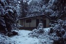
Ada Pass Hut
Photograph
•
Distance: 6.5km away
Ada Pass Hut after a seasonal March snowfall.
More ▶︎
St James Walkway June 2009
Photograph
•
Distance: 6.8km away
Gloriana and the Faerie Queene, on a brilliant winter's day.
More ▶︎
Boyle Flats Hut
Photograph
•
Distance: 6.8km away
Perched high on a river terrace, accessed from a swingbridge 'on the Boyle'.
More ▶︎
St James Conservation Area
Place
•
Place. 781.96km2.
•
Distance: 6.8km away
A large new recreational area featuring tussock grasslands, and including the headwaters of the Waiau and Clarence Rivers.
More ▶︎
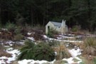
St James Walkway
Track
•
5 days. Easy/medium. One way.
•
Distance: 6.8km away
A long and easy walk on St James Station near Lewis Pass. Beech forest, mountain scenery, farmland, wild horses, mud.
More ▶︎
Ada Cullers Hut
Photograph
•
Distance: 6.8km away
Tidy old shack provides shelter and shade from the elements. No mattresses or water supply.
More ▶︎
St Arnaud to Lewis Pass
Track
•
5 – 9 days. Medium/hard. One way.
•
Distance: 7.3km away
A 5-9 day north-south route from St Arnaud to the Lewis Pass, via Travers Pass, Waiau Pass, Thompson Pass and ...
More ▶︎
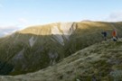
Frosty Morning Maruia River
Photograph
•
Distance: 7.3km away
Trampers on a frosty morning in the upper Maruia River near Cannibal Gorge.
More ▶︎
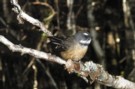
Fantail
Photograph
•
Distance: 7.3km away
Fantail near Cannibal Gorge Hut on the Saint James Walkway
More ▶︎
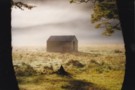
Cannibal Gorge Hut
Photograph
•
Distance: 7.3km away
Cannibal Gorge Hut is the first hut on the St James walkway from the Lewis Pass end. Sleeps 20. Nice ...
More ▶︎
Cannibal Gorge Hut
Photograph
•
Distance: 7.3km away
Cannibal Gorge Hut is the first hut on the St James walkway from the Lewis Pass end
More ▶︎
Cannibal Gorge Hut
Hut
•
Serviced Hut (DOC). Capacity: 20.
•
Distance: 7.4km away
The first hut on the western end of the St James Walkway.
More ▶︎
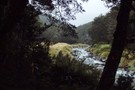
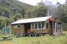
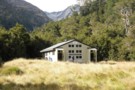
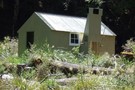
Bob's Hut
Photograph
•
Distance: 8.3km away
Bob's Hut, located in wide valley flats on the west branch of the Matakitaki River.
More ▶︎
Bob's Hut
Hut
•
Standard Hut (DOC). Capacity: 8.
•
Distance: 8.3km away
Bob was to be absent when I arrived - though a cross outside hints at possible reasons. Hut book entries ...
More ▶︎
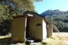
Pell Stream Hut
Hut
•
Basic Hut/Bivvy (DOC). Capacity: 4.
•
Distance: 8.3km away
Small hut at the end of the Pell Stream Track.
More ▶︎
Pell Stream hut August 2011
Photograph
•
Distance: 8.3km away
Neil B & I recently visited this hut. There have been some track improvements since I was last there. Hut ...
More ▶︎
Pell Stream hut Dec 2008
Photograph
•
Distance: 8.3km away
We visited this hut as a day trip from the Marble Hill camping area.
It seemed a good comfortable hut with ...
More ▶︎
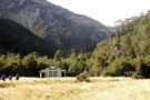
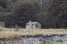
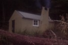
Bob's Hut
Photograph
•
Distance: 8.5km away
First view of Bob's Hut across the grassy flat (in the middle of the photo at the treeline - it ...
More ▶︎
Blue Lake Hut - Bobs Hut
GPX file
•
Distance: 8.5km away
Blue Lake campsite to Bob’s Hut, via Lake Thompson and D’Urville Pass
An actual, recorded, gpx – the high route section ...
More ▶︎
Freyberg Range, Pell Stream
Article
•
Distance: 9.2km away
A 3 day trip, climbing up onto the range to go over Mt Mueller and camp. Followed by a descent ...
More ▶︎
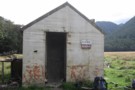
Thompson's Flat Hut
Photograph
•
Distance: 9.2km away
Thompson's Flat Hut, north of Lake Daniells. A 4 bunk forestry hut.
More ▶︎
Thompson's Flat Hut
Hut
•
Basic Hut/Bivvy (PVT). Capacity: 4.
•
Distance: 9.4km away
An old hunters hut near Lake Daniell. This is a private hut on private land.
More ▶︎
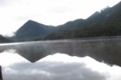
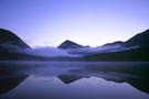
Morning @ Lake Daniells
Photograph
•
Distance: 9.7km away
Morning @ Lake Daniells view from the hut
More ▶︎
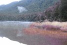
Morning @ Lake Daniells
Photograph
•
Distance: 9.7km away
Morning @ Lake Daniells from jetty
More ▶︎
Thompsons Flat Hut
Photograph
•
Distance: 9.7km away
A great hut to escape to, an hour or so beyond Lake Daniells and away from the crowds, sleeps 4 ...
More ▶︎
Lake Daniells
Photograph
•
Distance: 9.7km away
10-15 minutes walk from the start of the track.
More ▶︎
Lake Daniells
Track
•
1 – 2 days. Easy. Return via same track.
•
Distance: 9.7km away
Lake Daniells is a tranquil, shallow lake west of Lewis Pass. The walk in is along easy, well-maintained tracks through ...
More ▶︎
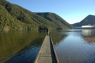
Lake Daniells from hut
Photograph
•
Distance: 9.7km away
Lake Daniells and jetty from Manson-Nicholls Memorial Hut. Photo taken by Andrea
More ▶︎
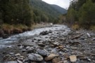
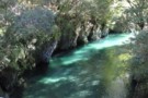
Pell Stream
Photograph
•
Distance: 9.8km away
open travel just above the second gorge section (going up)
More ▶︎
Zampa panorama
Photograph
•
Distance: 10.0km away
180 panorama from the tarn below Zampa
(click the photo to see the whole thing)
(L to R) : Zampa tops, Philosophers ...
More ▶︎
Philosophers Knob
Photograph
•
Distance: 10.0km away
from the tarn below Zampa Peak (March 2020).
Main access route is up (500m) an unnamed stream from Maruia River (right ...
More ▶︎