Nearby
Red Stag Hut
Te Kahui Kaupeka Conservation Park
Place
•
Conservation Park. 938.00km2.
•
Distance: 105m away
Canterbury high country park including the Two Thumb Range and large portions of Mesopotamia Station.
More ▶︎
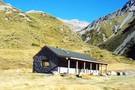
Eade Memorial Hut
Hut
•
Private hut (NZDA). Capacity: 6.
•
Distance: 2.9km away
NZDA hut located moraine, on the true left of the Godley River, close to a number of glaciers and lakes.
More ▶︎
Separation Stream
Photograph
•
Distance: 5.2km away
Separation Stream is on the true left of the Godley River not far downstream from the Godley Hut. The ridge ...
More ▶︎
Godley Hut
Photograph
•
Distance: 6.7km away
Godley hut 1969. The hut was quite close to the terminal face of the Godley Glacier then, but the end ...
More ▶︎
Godley Hut
Hut
•
Standard Hut (NZAC). Capacity: 8.
•
Distance: 6.7km away
Historic hut opened 24 December 1934. This hut is located above Fitzgerald Stream at the head of the Godley Valley, ...
More ▶︎
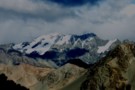
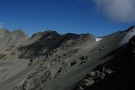
Mount Sibbald
Photograph
•
Distance: 6.7km away
Mount Sibbald, from the col between Lower Tindall Stream and North Branch. An short day walk from the nearby Macauley ...
More ▶︎
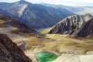
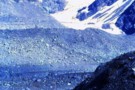
Tarns, Lower Tindall Stream
Photograph
•
Distance: 6.9km away
Tarns at the head of the Lower Tindall Stream, above Macauley Hut.
More ▶︎
Picton to Aspiring
GPX file
•
Distance: 7.1km away
An aborted alpine traverse. Picton to West Cape, but aborted at Aspiring due to real world emergencies back home. Posted ...
More ▶︎

Route Guide: Otira to Mt Cook Village (pt 2)
Track
•
12 – 21 days. Hard. One way.
•
Distance: 7.2km away
One possible route down the main divide from Otira on the Arthur's Pass road to Mt Cook Village.
Otira Hotel ...
More ▶︎
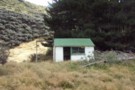
Rankin Hut
Photograph
•
Distance: 7.2km away
Rankin Hut- a private station hut in the Godley Valley
More ▶︎

Route Guide: Otira to Mt Cook Village (pt 1)
Track
•
12 – 21 days. Hard. One way.
•
Distance: 7.2km away
One possible route down the main divide from Otira on the Arthur's Pass road to Mt Cook Village.
Otira Hotel to ...
More ▶︎
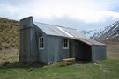
Rankin Hut
Hut
•
Private hut (PVT). Capacity: 6.
•
Distance: 7.2km away
Rankin Hut (private, 6 bunks. mattresses, wood-burning cooking stove, firewood available, stream water) is a station hut on the flats ...
More ▶︎
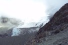
Murchison Hut
Hut
•
Serviced Alpine Hut (NZAC). Capacity: 10.
•
Distance: 9.0km away
This hut sits high above the Muchison Glacier.
More ▶︎
Havelock River to MacAuley River
GPX file
•
Distance: 9.3km away
route taken from Growler Hut, Havelock River to MacAuley Hut, Macauley River via Growler Creek, Balaclava Col, Plata Col & ...
More ▶︎
Upper Macauley Valley
Photograph
•
Distance: 9.5km away
Upper Macauley Valley from Macauley Hut.
More ▶︎
Macauley Hut
Photograph
•
Distance: 9.5km away
Macauley Hut, a luxurious public hut in the Macauly valley.
More ▶︎
Macaulay Hut
Hut
•
Serviced Hut (Mackenzie Alpine Trust). Capacity: 14.
•
Distance: 9.5km away
Macaulay Hut (14 bunks, matresses, stove, firewood provided, water, bath, mountain radio, gas cookers, lighting) is a luxury option for ...
More ▶︎
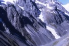
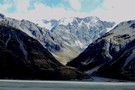
Huxley Glacier
Photograph
•
Distance: 10.0km away
The Huxley Glacier, in the upper Cass River - seen from Rankin Pass.
More ▶︎
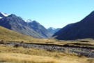
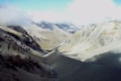
Rankin Stream / Rankin Pass
Photograph
•
Distance: 10.0km away
Rankin Stream from the Godley River flats. The notch on the left of the valley is the Rankin Pass, a ...
More ▶︎
Cass River, East Branch
Photograph
•
Distance: 10.0km away
The head of the Cass river from Rankin Saddle. The Huxlrey glacier descends into the western half of the valley ...
More ▶︎
Rankin Pass
Photograph
•
Distance: 10.0km away
Technically easy, few hours from Rankin Hut in Godley. Few more hours down to Cass Memorial Hut.
More ▶︎