Nearby
Murchison Hut
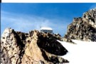
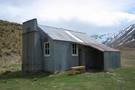
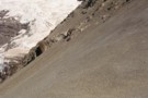
Kelman Hut at the head of the Tasman Glacier
Photograph
•
Distance: 2.6km away
We used the hut whilst undertaking a TMC with Alpine Guides MtCook.
More ▶︎
Kelman Hut
Hut
•
Serviced Alpine Hut (DOC). Capacity: 22.
•
Distance: 2.8km away
Large and modern alpine hut at the head of the Tasman Glacier.
More ▶︎
Tasman Saddle Hut
Hut
•
Serviced Alpine Hut (DOC). Capacity: 14.
•
Distance: 4.3km away
Mountaineering hut located at the head of the Haupapa / Tasman Glacier.
More ▶︎
Eade Memorial Hut
Hut
•
Private hut (NZDA). Capacity: 6.
•
Distance: 7.1km away
NZDA hut located moraine, on the true left of the Godley River, close to a number of glaciers and lakes.
More ▶︎
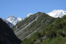
View west from Whymper hut Jan 2012
Photograph
•
Distance: 8.7km away
Looking west from the hut.
More ▶︎
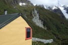
Whymper hut Jan 2012
Photograph
•
Distance: 8.7km away
A close up of Whymper hut taken from the track to the toilet. The perspective is looking NE with the ...
More ▶︎
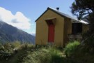
Whymper hut
Hut
•
Standard Hut (DOC). Capacity: 6.
•
Distance: 8.7km away
This is another South Westland 1974 built ex NZFS six bunker. It is set in spectacular surroundings in the headwaters ...
More ▶︎
Whymper hut setting Jan 2012
Photograph
•
Distance: 8.7km away
This is another South Westland 1974 built ex NZFS six bunker. It is set in spectacular surroundings in the headwaters ...
More ▶︎
Red Stag Hut
Hut
•
Basic Hut/Bivvy (NZDA). Capacity: 6.
•
Distance: 9.0km away
NZDA hut on the true left of the Godley River. This hut can be driven to with a 4WD.
More ▶︎
Te Kahui Kaupeka Conservation Park
Place
•
Conservation Park. 938.00km2.
•
Distance: 9.1km away
Canterbury high country park including the Two Thumb Range and large portions of Mesopotamia Station.
More ▶︎
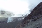
Huxley Glacier
Photograph
•
Distance: 10.0km away
The Huxley Glacier, in the upper Cass River - seen from Rankin Pass.
More ▶︎

Route Guide: Otira to Mt Cook Village (pt 2)
Track
•
12 – 21 days. Hard. One way.
•
Distance: 10.0km away
One possible route down the main divide from Otira on the Arthur's Pass road to Mt Cook Village.
Otira Hotel ...
More ▶︎
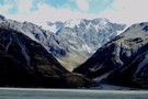
Cass River, East Branch
Photograph
•
Distance: 10.0km away
The head of the Cass river from Rankin Saddle. The Huxlrey glacier descends into the western half of the valley ...
More ▶︎
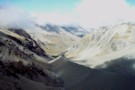
Rankin Stream / Rankin Pass
Photograph
•
Distance: 10.0km away
Rankin Stream from the Godley River flats. The notch on the left of the valley is the Rankin Pass, a ...
More ▶︎

Route Guide: Otira to Mt Cook Village (pt 1)
Track
•
12 – 21 days. Hard. One way.
•
Distance: 10.0km away
One possible route down the main divide from Otira on the Arthur's Pass road to Mt Cook Village.
Otira Hotel to ...
More ▶︎
Rankin Pass
Photograph
•
Distance: 10.0km away
Technically easy, few hours from Rankin Hut in Godley. Few more hours down to Cass Memorial Hut.
More ▶︎