Nearby
Hauhungatahi Wilderness Area
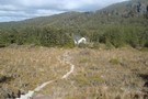
Hauhungatahi Track
GPX file
•
Distance: less than 100m away
Hauhungatahi, also called Baldy, is the prominent hill just outside National Park. It is in a remote experience zone so ...
More ▶︎
Hauhungatahi Track
Track
•
1 day. Easy/medium. Return by the same track.
•
Distance: less than 100m away
Hauhungatahi, also called Baldy, is the prominent hill just outside National Park. It is in a remote experience zone so ...
More ▶︎
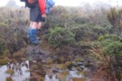
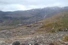
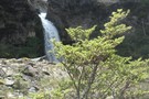
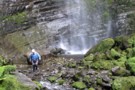
A rather damp track on Hauhungatahi
Photograph
•
Distance: 1.3km away
The track above bushline on Hauhungatahi has no shortage of water on it
More ▶︎
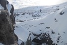
Mt Hauhungatahi (Baldy)
GPX file
•
Distance: 3.9km away
Although meandering in some places, these GPX coordinates should get you up and down Mt Hauhungatahi (Baldy) without too much ...
More ▶︎
Whakapapaiti Valley Loop (Tongariro National Park)
GPX file
•
Distance: 5.0km away
This is a delightful six hour day trip from the Whakapapa Village Visitors Centre. Take your lunch and enjoy the ...
More ▶︎
Whakapapiti Valley Loop (Tongaririo National Park)
GPX file
•
Distance: 5.0km away
This is a delightful easy six hour day trip from the Whakapapa Village Visitors Centre. Take your lunch and enjoy ...
More ▶︎
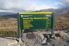
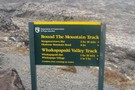
Round The Mountain (Ruapehu) - Stage 3
GPX file
•
Distance: 5.7km away
This is an excellent day trip in good weather, or can be conveniently split into an overnight trip with a ...
More ▶︎
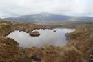
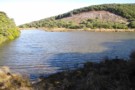
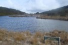
Mountain Tarn
Photograph
•
Distance: 5.7km away
Looking towards Hauhungatahi volcano which is thought to have erupted about 900,000 years ago, and therefore is significantly older than ...
More ▶︎
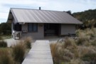
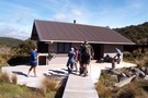
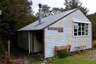
Whakapapaiti Hut
Photograph
•
Distance: 6.4km away
18 Bunk hut part of the ruapehu round the mountain track
More ▶︎
Whakapapaiti
Hut
•
Serviced Hut (DOC). Capacity: 18.
•
Distance: 6.4km away
18 Bunk hut 2.5hrs from Whakapapa Village
More ▶︎

National Park Villiage
Place
•
Place.
•
Distance: 7.0km away
A sleepy ski resort near Tongariro National Park. It is on the main trunk railway line and is home to ...
More ▶︎

Te Araroa Trail
Track
•
95 days. Medium. One way.
•
Distance: 7.0km away
Te Araroa is a walking trail running the entire length of the North and South Islands. The trail opened 3 ...
More ▶︎
Rotorua Tramping & Skiing Club
Club
•
Distance: 7.1km away
We are an active tramping club with trips most weekends. We also have a lodge on Mt Ruapehu and 2 ...
More ▶︎
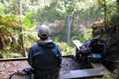
Tupapakurua Falls
GPX file
•
Distance: 7.4km away
A nice bush walk near National Park Village. Would make a good alternative to the Tongariro Crossing if the weather ...
More ▶︎
Silica Rapids Walk
Track
•
Easy. Loop track with a road section.
•
Distance: 7.7km away
Creamy-white aluminosilicate deposits near Whakapapa village.
More ▶︎
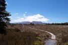
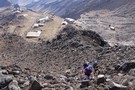
Ruapehu round the mountain track
Photograph
•
Distance: 7.9km away
Board walk on the Ruapehu round the mountain track west of Whakapapa village.
More ▶︎
Round the Mountain: Ruapehu
Track
•
5 days. Easy/medium. Loop track.
•
Distance: 8.1km away
Combined with part of the Tongariro Northern Circuit, this track forms a loop around Mt Ruapehu. Combined with the other ...
More ▶︎
Whakapapaiti Valley
Track
•
1 day. Easy. Loop track with a road section.
•
Distance: 8.1km away
This is an easy day trip in summer from Whakapapaiti Village. Allow about six hours, but you can do it ...
More ▶︎
Bruce Road
Photograph
•
Distance: 8.4km away
Exit point for Round the Mountain track on Bruce Road above Whakapapa village.
More ▶︎
Lake Suprise
Photograph
•
Distance: 8.5km away
Lake Suprise close up. When calm it has nice reflections
More ▶︎
Lake Suprise, looking across the Mangaturuturu Valley
Photograph
•
Distance: 8.5km away
Lake Suprise is a populat day walk from the Ohakune Mountain Rd
More ▶︎
Lake Surprise
Track
•
1 day. Medium. Return via same track.
•
Distance: 8.5km away
Walk to Lake Suprise, Mountain Track
More ▶︎
Whakapapanui Track
Track
•
Easy. Return via road or same track.
•
Distance: 8.5km away
An easy all-weather walk through forest alongside the Whakapapanui Stream.
More ▶︎
Tupapakurua Falls
Track
•
0 – 1 day. Easy. Return via same track.
•
Distance: 8.6km away
A nice bush walk near National Park Village. Would make a good alternative to the Tongariro Crossing if the weather ...
More ▶︎
Whakapapa Nature Walk
Track
•
Easy. Loop track.
•
Distance: 8.8km away
A brief sealed track introducing the park's vegetation zonation.
More ▶︎
Whakapapa Village
Place
•
Place.
•
Distance: 8.8km away
A small village located inside Tongariro National Park, a World Heritage Area.
More ▶︎
Tongariro Northern Circuit
GPX file
•
Distance: 8.8km away
A complete log of the Tongariro Northern Circuit completed on March 8, 2008.
More ▶︎
Mangaturuturu Hut
Photograph
•
Distance: 9.0km away
This hut has a long history associated with the Wanganui Tramping Club. It is now administered by DOC and is ...
More ▶︎
Mangaturuturu Hut
Hut
•
Standard Hut (DOC). Capacity: 8.
•
Distance: 9.0km away
Hut on the walk from Turoa Road to Lake Surprise, about 1.5 hours in.
More ▶︎
Tongariro Northern Circuit
Track
•
3 – 4 days. Easy/medium. Loop track.
•
Distance: 9.0km away
This circuit on the Volcanic Plateau passes close to the summit of Tongariro in a spectacular, active volcanic landscape of ...
More ▶︎
Tama Lakes Track
Track
•
Medium. Return via same track.
•
Distance: 9.1km away
A good day walk onto the Tama Saddle, visiting explosion craters near the foot of Ngauruhoe. Excellent panoramic views on ...
More ▶︎
Ridge Track
Track
•
Easy. Return via same track.
•
Distance: 9.1km away
A brief climb onto the subalpine shrub fields offering panoramic views.
More ▶︎
Round The Mountain (Ruapheu)
GPX file
•
Distance: 9.2km away
Stage 1 Round The Mountain Track
More ▶︎
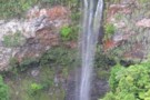
Tupapakurua Falls
Photograph
•
Distance: 9.2km away
The best view of the falls is from the lookout atthe top of the bluff
More ▶︎
ATC Memorial hut, Ruapehu
Photograph
•
Distance: 9.3km away
ATC memorial hut, Iwikau village, Mt Ruapehu. taken August 2005.
More ▶︎
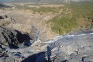
Mangaturuturu falls
Photograph
•
Distance: 9.3km away
Mangaturuturu waterfall, about 1km downstream from Mangaturuturu hut.
taken Feb 2006.
More ▶︎
The bottom of Tupapakurua Falls
Photograph
•
Distance: 9.3km away
If you are brave you can go to the bottom of the falls. It is a wet and slippery experience.
More ▶︎
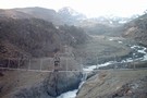
Wangaehu River Swing Bridge - Round The Mountain (Ruapehu)
Photograph
•
Distance: 9.3km away
Site of the lahar that flowed down from the crater lake.
More ▶︎
Mt Ruapehu Crater Lake
GPX file
•
Distance: 9.7km away
This trip goes up to the Crater Lake from the Top of the Bruce and then comes down via the ...
More ▶︎
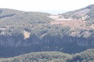
Maungaturuturu Valley
Photograph
•
Distance: 9.9km away
Steep cascade descending into Maungaturuturu Valley
More ▶︎