Nearby
Hooker Landsborough Wilderness Area
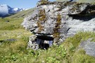
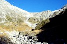
Marks Flat Rock Biv
Rock bivouac
•
Distance: 2.8km away
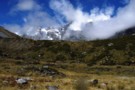
Marks Flat is a wide basin beneath Mount Hooker. It is strewn with boulders, one of which affords shelter.
More ▶︎
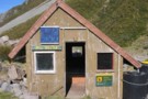
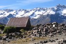
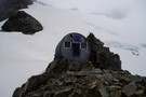
Barron Saddle Hut
Hut
•
Serviced Alpine Hut (DOC). Capacity: 8.
•
Distance: 3.2km away
An iron cylinder near Barron Saddle.
More ▶︎
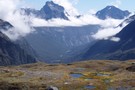
Head of Landsborough
Photograph
•
Distance: 3.8km away
Taken from Douglas pass with Karangarua Saddle to right in distance
More ▶︎
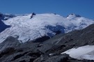
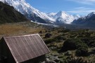
Mueller Hut
Track
•
1 – 2 days. Medium. Return by the same track.
•
Distance: 4.0km away
Day or overnight trip to an alpine hut with views of Aoraki / Mount Cook. Best walked mid-November to March ...
More ▶︎
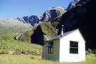
Harpers Rock Biv
Rock bivouac
•
Distance: 4.0km away
Located on a broad shelf of moraine above Douglas Lake. The biv is located near the edge of the shelf, ...
More ▶︎
Lake Douglas
Photograph
•
Distance: 4.1km away
Taken from the Morraine Wall above the lake head, Moss Flat near AP HArper Rock Biv. Traverse is on true ...
More ▶︎
Tunnel Creek Rock Biv
Rock bivouac
•
Distance: 4.2km away
A substantial slab of overhanging rock at about the tree line, on the spur west of the Buttress and Mount ...
More ▶︎
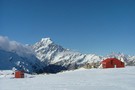
Mueller Hut
Hut
•
Serviced Alpine Hut (DOC). Capacity: 28.
•
Distance: 4.3km away
Mueller hut is surrounded by Mt. Cook and other 3000m peaks, making it a scenic place to stay. In summer ...
More ▶︎
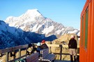
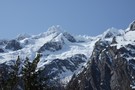
Mueller Hut and Aoraki/Mt Cook
Photograph
•
Distance: 4.3km away
Mueller Hut and Aoraki/Mt Cook
More ▶︎
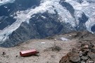
Above Mueller Hut
Photograph
•
Distance: 4.3km away
Looking Down on Mueller hut and across to Mt. Cook from Mt. Olivier.
Photo taken in January 2008.
More ▶︎
Sealy Tarns
Track
•
Easy/medium. Return by the same track.
•
Distance: 5.3km away
Steep track with lots of steps, but easy and well-maintained. The tarns are roughly half-way to Mueller Hut. From the ...
More ▶︎
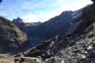
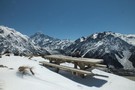
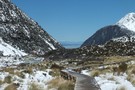
view from mueller hut route
Photograph
•
Distance: 5.3km away
In winter there is usually little sign of a track after passing Sealy Tarns, the hill is covered in snow, ...
More ▶︎
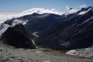
Douglas / Horace Walker valleys from Mt Howitt
Photograph
•
Distance: 5.7km away
Douglas / Horace Walker valleys from Mt Howitt
More ▶︎
Madpom's survival camp, Mt Howitt, Douglas valley
Photograph
•
Distance: 5.7km away
Madpom survivied 9 days here before giving up on rescue and walking (crawling) out to Horace Walker Hut 3 km ...
More ▶︎
Sierra Range / Douglas Neve
Photograph
•
Distance: 5.8km away
Sierra Range / Douglas Neve from Mt Howitt
More ▶︎
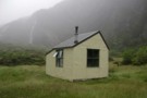
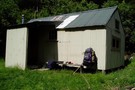
outside tunnel creek hut
Photograph
•
Distance: 6.0km away
the views from the doorway at tunnel creek hut - paringa river
More ▶︎
Tunnel Creek Hut Refreshed
Article
•
Distance: 6.0km away
There are only a handful of remote huts in south westland but DOC doesn't always appear committed to their conservation. ...
More ▶︎

Tunnel Creek Hut in the Paringa
Photograph
•
Distance: 6.0km away
Tunnel Creek has been sheltering all comers in the head of the Paringa for almost fifty years. Built by the ...
More ▶︎
Paringa Valley to Tunnel Creek
Track
•
Easy/medium. Return by the same track.
•
Distance: 6.0km away
Its a Southern West Coast gem: the valley floor is surprisingly gentle, the track currently well marked and for the ...
More ▶︎
Map - Tunnel Creek Hut
Photograph
•
Distance: 6.0km away
Tunnel Creek Hut - Center of the wilderness.
More ▶︎
where's Dulux
Photograph
•
Distance: 6.0km away
sure it needs a coat of paint - but the iron and the hut are perfectly sound. Most of the ...
More ▶︎
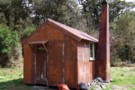
Tunnel Creek hut Oct 2008
Photograph
•
Distance: 6.0km away
This hut is on the TL of the Paringa River in South Westland. The hut is close (4-5km) to the ...
More ▶︎
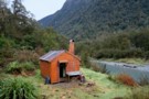
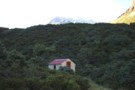
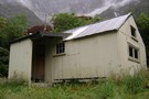
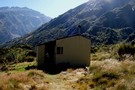
Tunnel Creek hut
Hut
•
Basic Hut/Bivvy (DOC). Capacity: 6.
•
Distance: 6.0km away
This hut is on the TL of the Paringa River in South Westland. The hut is close (4-5km) to the ...
More ▶︎
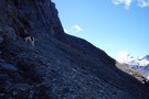
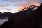
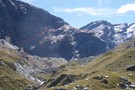
Karangarua Saddle ascent - 'The Ledge'
Photograph
•
Distance: 6.1km away
The 'ledge' ascending through bluffs to the Karangarua Saddle from the Landsborough. Looks better close up!
More ▶︎
Mad Pom's latest adventure. Part 2
Article
•
Distance: 6.1km away
A trip to the head on the landsborough, and all that ensues. Part two.
More ▶︎
Mad Pom's latest adventure
Article
•
Distance: 6.1km away
A trip to the heads of the Landsborough ... and all that ensues.
More ▶︎
The head of the Landsborough
Photograph
•
Distance: 6.1km away
The Landsborough upriver of the karangarua Saddle.
More ▶︎
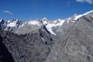
The Karangarua
Photograph
•
Distance: 6.1km away
The upper Karangarua Saddle from the Karangarua Saddle
More ▶︎
Karangarua Saddle
Photograph
•
Distance: 6.1km away
Karangarua Saddle, the ascent from the Landsborough shown in red. A 10m wide scree shelf ascends from the base of ...
More ▶︎
Mad Pom's latest Adventure - Part 5
Article
•
Distance: 6.2km away
A trip to the head of the Landsborough - and all that ensues.
Part 5 - Heroes and Angels.
More ▶︎
Mad Pom's latest Adventure - part 4
Article
•
Distance: 6.2km away
A trip to the head of the Landsborough - and all that ensues.
Part 4: the longest walk.
More ▶︎
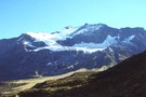
Mount Hopkins
Photograph
•
Distance: 6.2km away
Mount Hopkins, in the upper Dobson. Readon hut lies on the valley floor, to the left of the peak.
More ▶︎
Rubicon Biv
Hut
•
Shelter (DOC). Capacity: 2.
•
Distance: 6.4km away
A neat natural rock bivouac located on the northern terraces of Rubicon Torrent in the upper Lansborough. Water is only ...
More ▶︎
Rubicon Rock Biv
Rock bivouac
•
Distance: 6.5km away
Located on a terrace above the fork of Rubicon Torrent with the Landsborough River. The biv has been enclosed by ...
More ▶︎
Rubicon Flats and Mt Barnes, Landsborough
Photograph
•
Distance: 6.5km away
Rubicon Flats and Mt Barnes, Landsborough. Supposedly there's a rock biv on top of the grassed over lateral moraine in ...
More ▶︎
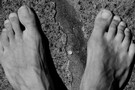
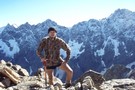
Munted Feet
Photograph
•
Distance: 6.6km away
May my thoughts be like at evening an Otago sky where detonated clouds in calm confusion lie - Glover
More ▶︎
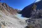
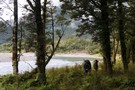
Hooker Valley Track
Track
•
Easy. Return by the same track.
•
Distance: 6.6km away
Mostly flat, easy and touristy track along the Hooker River from White Horse campground to the Hooker Glacier. Great views.
More ▶︎
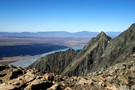
Tasman valley from Jamieson Saddle
Photograph
•
Distance: 6.7km away
A look back towards the coast from Jamieson Saddle: views over the Tasman Valley, Lake Pukaki, Burkes Pass and the ...
More ▶︎
Jamieson Saddle
Photograph
•
Distance: 6.7km away
Jamieson Saddle summit, 2187m - looking west across the upper Dobson towards the Sealy Range. Jamieson saddle is an unmarked ...
More ▶︎
Te Wāhipounamu - South West New Zealand World Heritage Area
Place
•
World Heritage Area. 26000.00km2.
•
Distance: 7.0km away
This UNESCO World Heritage Area occupies the southwestern corner of New Zealand. It includes four national parks, and covers 10% ...
More ▶︎
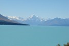
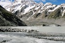
A fine day to view Mt Cook
Photograph
•
Distance: 7.3km away
Anyone who has driven between Christchurch and Wanaka / Queenstown area on a fine day would surely have this photo.
More ▶︎
Ball Shelter Hut
Photograph
•
Distance: 7.3km away
Tasman Valley, Mount Cook National Park. View to range on other side of the Tasman Glacier.
More ▶︎

Route Guide: Otira to Mt Cook Village (pt 2)
Track
•
12 – 21 days. Hard. One way.
•
Distance: 7.3km away
One possible route down the main divide from Otira on the Arthur's Pass road to Mt Cook Village.
Otira Hotel ...
More ▶︎

Route Guide: Otira to Mt Cook Village (pt 1)
Track
•
12 – 21 days. Hard. One way.
•
Distance: 7.3km away
One possible route down the main divide from Otira on the Arthur's Pass road to Mt Cook Village.
Otira Hotel to ...
More ▶︎
Main Divide south of Copland headwaters Oct 2010
Photograph
•
Distance: 7.5km away
This pic was taken about 15 mins above Douglas Rock hut. I think the prominent peak is The Footstool? Mt ...
More ▶︎
Toetoe Biv
Photograph
•
Distance: 7.6km away
Toetoe Biv, Landsborough. The river's up, so wasn't able to check out this cozy looking biv.
More ▶︎
Hooker Valley Track
Photograph
•
Distance: 7.6km away
Hooker Valley Track walkboard, looking towards the valley
More ▶︎
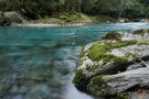
crystal clear paringa river
Photograph
•
Distance: 7.7km away
Fresh water in Westland, the river is so clear it makes crossing tricky - its always deeper than it looks! ...
More ▶︎
Readon Hut
Photograph
•
Distance: 7.9km away
Readon Hut, in the upper Dobson., Despite being only 8km from Mt Cook Village, this hut is most commonly accessed ...
More ▶︎
Readon Hut / Reardon Hut
Hut
•
Basic Hut/Bivvy (DOC). Capacity: 2.
•
Distance: 7.9km away
Rea(r)don Hut (2 bunks, matresses, tank water, no fire) is a large bivvy / small hut near the head of ...
More ▶︎
Picton to Aspiring
GPX file
•
Distance: 8.0km away
An aborted alpine traverse. Picton to West Cape, but aborted at Aspiring due to real world emergencies back home. Posted ...
More ▶︎
Christmas Flat Hut
Photograph
•
Distance: 8.5km away
Standard DOC hut in the head of the Karangarua Velley, South Westland.
More ▶︎
Christmas Flat Hut
Hut
•
Standard Hut (DOC). Capacity: 4.
•
Distance: 8.5km away
Located on Christmas Flat in the head of the Karangarua Valley. Mainly used by hunting parties who helicopter in. Because ...
More ▶︎
Copland Track
Track
•
3 days. Hard. One way.
•
Distance: 8.5km away
Classic mountaineering route between Mount Cook and the West Coast. See Welcome Flat.
More ▶︎
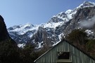
Douglas Rock Hut, Southwestland
Photograph
•
Distance: 8.6km away
Nice little hut at the top end of the Copland Vally.
Awsome fireplace and sone surround.
More ▶︎
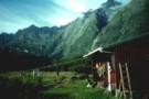
Horace Walker Hut
Hut
•
Standard Hut (DOC). Capacity: 4.
•
Distance: 8.8km away
Small (4 bunk, pioneer stove, limiter firewood, stream water @ 200m), isolated hut on the Douglas River west of Mount ...
More ▶︎
Horace Walker Hut (Douglas)
Photograph
•
Distance: 8.8km away
Horace Walker Hut, below the Horace Walker Glacier in the Douglass Valley, West Coast.
More ▶︎
Christmas Flat Hut
Photograph
•
Distance: 8.8km away
Chistmas Flat Hut on a wet February day. This is a cosy four bunk hut at the head of the ...
More ▶︎
Douglas Rock Hut
Hut
•
Standard Hut (DOC). Capacity: 8.
•
Distance: 8.9km away
Standard DOC hut
More ▶︎
Douglas Rock hut & SE view Oct 2010
Photograph
•
Distance: 8.9km away
There are nice back drops to this hut. Further up the valley beyond the scrub zone there are unimpeded views. ...
More ▶︎
Douglas Rock Hut
Photograph
•
Distance: 8.9km away
Standard DOC hut located on the Copland Track, east of Welcome Flat. It's well worth a day trip out and ...
More ▶︎
Cassel Flat Hut
Photograph
•
Distance: 8.9km away
On a pleasant river flat surrounded by spectacular rugged mountains
More ▶︎
Cassel Flat Hut
Hut
•
Standard Hut (DOC). Capacity: 6.
•
Distance: 8.9km away
Standard DOC hut in the Karangarua Valley
More ▶︎
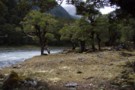
McKerrow Creek camp spots
Photograph
•
Distance: 9.1km away
Typical of camp spots beside most side creeks up the Landsborough. With only 2 huts, this is canvas country - ...
More ▶︎
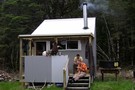
Lame Duck Hut
Hut
•
Standard Hut (DOC). Capacity: 4.
•
Distance: 9.1km away
Small hut in the Karangarua Valley.
More ▶︎
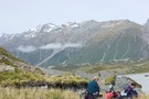
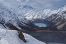
Sitting above the Hooker Glacier enroute from Ball Pass
Photograph
•
Distance: 9.1km away
Looking southward toward MtCook Village you've got a clear view of the route leading up to Mueller Hut
More ▶︎
Cloudmaker
Photograph
•
Distance: 9.1km away
Mount Cook (Aoraki) forms a large cloud, seen from the Hooker Lake.
More ▶︎
Lame Duck Hut
Photograph
•
Distance: 9.2km away
This is the new hut. Its a nice four bunk with a good fireplace. It is situated between Christmas flat ...
More ▶︎
paringa river - south bank
Photograph
•
Distance: 9.4km away
linking cattle trails on the way out from stew creek on the TL bank. There is often no marked trail ...
More ▶︎