Nearby
Olivine Wilderness Area
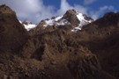
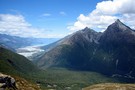
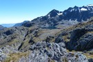
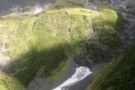
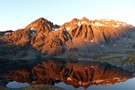
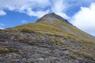
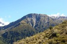
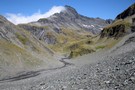
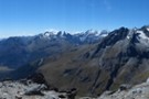
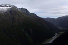
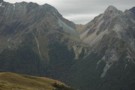
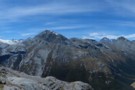
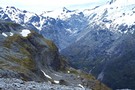
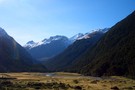
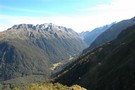
Red Mountain
Photograph
•
Distance: less than 100m away
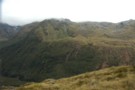
Red Mountain is the highest peak of the most remote ultramafic zone in deepest south westland. Travel on the bare ...
More ▶︎
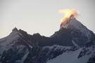
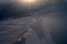
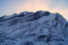
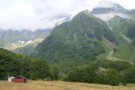
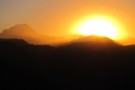
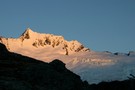
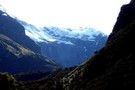
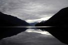
Is Aspiring erupting?
Photograph
•
Distance: 267m away
The sunset behind Mt.Aspiring provides some interesting effect.
More ▶︎

Mount Aspiring National Park
Place
•
National Park. 3555.18km2.
•
Distance: 546m away
The third-largest national park, although most of its space is under-utilised. The Routeburn is the second busiest trail in New ...
More ▶︎
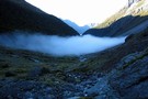
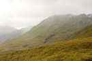
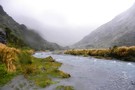
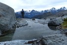
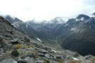
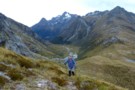
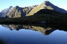
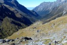
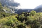
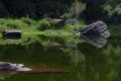
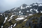
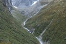
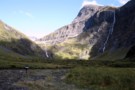
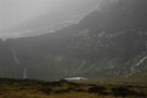
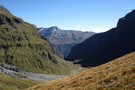
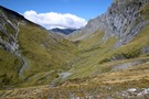
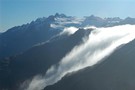
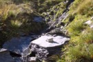
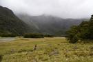
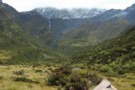
Morning mist, Hidden Falls creek
Photograph
•
Distance: 2.3km away
On the five passes route. Morning mist in upper Hidden Falls creek, not far from Cow saddle. taken Jan 2010
More ▶︎
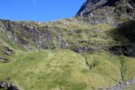
The Olivine Ledge
Photograph
•
Distance: 2.3km away
At around 1100M a grassy ledge takes you from a short distance down from Fiery Col to the outlet from ...
More ▶︎
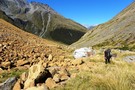
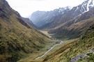
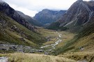
Heading down Hidden Falls creek
Photograph
•
Distance: 2.4km away
Leaving the campsite in Cow saddle after a morning of relaxation and clothes drying. It's just an afternoons walk to ...
More ▶︎
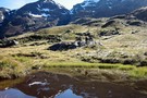
Fiery col from Olivine Ledge
Photograph
•
Distance: 2.5km away
On the five passes route. Fiery col (on the left) from Olivine Ledge. taken Jan 2010
More ▶︎
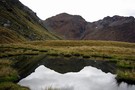
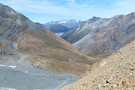
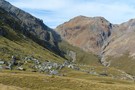
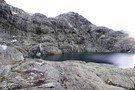
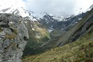
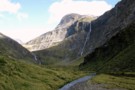
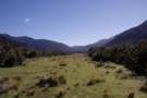
Cow saddle
Photograph
•
Distance: 2.5km away
On the five passes route. Cow saddle with Fiery col in the background. taken Jan 2010
More ▶︎
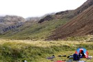
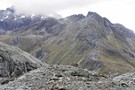
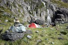
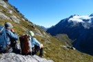
Here comes the cold half of the day
Photograph
•
Distance: 2.6km away
We didn't start walking until after midday and now with the descent from Fiery Col complete we settle down in ...
More ▶︎
Camp on Hidden Falls Creek
Photograph
•
Distance: 2.6km away
looking upstream, our campsite high on Hidden Falls Creek was a little exposed but above the early morning mist
More ▶︎
Five Passes via Lake Nerine and North Col
Article
•
Distance: 2.6km away
A classic tramp north of the Routeburn. Rather than exit via the Rockburn, we extended the trip through Lake Nerine ...
More ▶︎
Five Passes
Track
•
6 – 7 days. Medium/hard. Loop track.
•
Distance: 2.6km away
A classic trip starting and finishing at the Routeburn road.
The five passes are; Sugarloaf pass, Park pass, Cow saddle, Fiery ...
More ▶︎
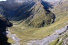
The descent to Cow Saddle from Fiery Col
Photograph
•
Distance: 2.6km away
Already down some 50m from the Col and the saddle area is coming into view. It's still another 4-500m to ...
More ▶︎
Fiery Col in fine weather
Photograph
•
Distance: 2.7km away
It's the first time i've come through here in clear weather.
What a view. We didn't get going till 1pm today. ...
More ▶︎
Fiery Col
Photograph
•
Distance: 2.7km away
looking across Cow Saddle into Hidden Falls Creek
Feb 2013
More ▶︎
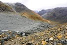
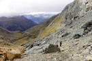
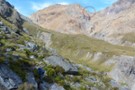
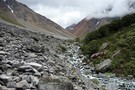
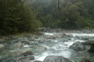
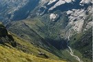
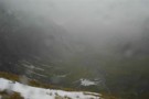
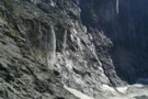
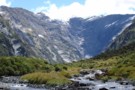
Scree Slopes in Hidden Falls Creek
Photograph
•
Distance: 2.7km away
An interesting mix of colours awaits you when you ascend Hidden Falls Ck toward Cow Saddle.
More ▶︎
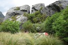
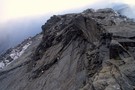
Fiery Col menhir
Photograph
•
Distance: 2.7km away
Photo Feb 2013, having begun the climb from the Olivine Ledge towards the Col
More ▶︎
The upper Beansburn from the rock bivvy
Photograph
•
Distance: 2.7km away
Some rain appears on the lens as it blows directly into the bivvy site. Good for us we can get ...
More ▶︎
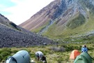
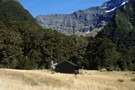
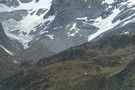
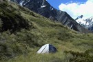
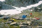
Beans Burn camp
Photograph
•
Distance: 2.7km away
On the five passes route. Camping next to the Beansburn rock biv -- there is room for a couple of ...
More ▶︎
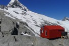
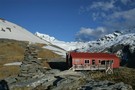
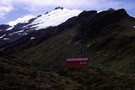
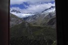
Colin Todd Hut
Photograph
•
Distance: 2.9km away
Perched on the side of Mt Aspiring above the Bonar Glacier, Colin Todd Hut serves as a base for climbers. ...
More ▶︎
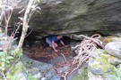
Forgotten River Rock Biv
Rock bivouac
•
Distance: 3.0km away
Located above the basin at the head of the Forgotten River, west of Forgotten River Col. The biv offers a ...
More ▶︎
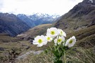
Olivine Ledge
Photograph
•
Distance: 3.0km away
On the five passes route. View of the Olivine Ledge from just below Fiery col. And a Mt Cook lily ...
More ▶︎
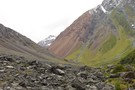
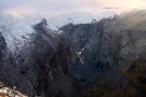
Ultramafic rocks, Hidden Falls Creek
Photograph
•
Distance: 3.2km away
On the five passes route. Ultramafic rocks in upper Hidden Falls creek. taken Jan 2010
More ▶︎
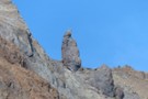
Menhir at Fiery Col
Photograph
•
Distance: 3.3km away
Approaching Fiery Col from the Olivine Ledge, there is a small but distinct menhir off to the right - Penguin ...
More ▶︎
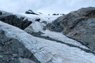
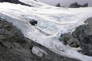
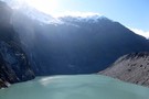
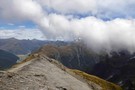
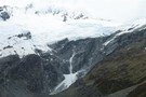
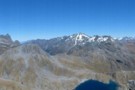
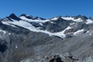
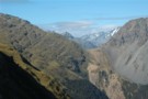
Park Pass Glacier
Photograph
•
Distance: 3.5km away
a highly recommended side trip on the 5 Passes tramp
Feb 2013
More ▶︎
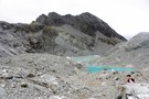
Terminal lakes of Park Pass glacier
Photograph
•
Distance: 3.5km away
To the north of Park Pass (1175m) is Poseidon Pk(2208m) from which flows Park Pass glacier to appx 1500m. It ...
More ▶︎
Park Pass Glacier
Photograph
•
Distance: 3.5km away
some of the breath-taking scenery on the descent from the glacier
Feb 2013
More ▶︎
Park Pass glacier - close up the snout.
Photograph
•
Distance: 3.6km away
The neve certainly looks very accessible from the terminal end. It was only the time factor which disallowed us the ...
More ▶︎
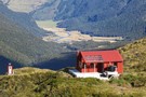
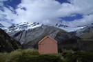
Colin Todd Hut
Hut
•
Serviced Alpine Hut (NZAC). Capacity: 12.
•
Distance: 3.7km away
This 1996 hut replaced the original, constructed in 1960. It was named after one of the best-known Post-War New Zealand ...
More ▶︎
Close up of Park Pass Glacier
Photograph
•
Distance: 3.7km away
Showing the snout of the glacier with the tip obscured by the rock wall. Taken from above the steep snowgrass ...
More ▶︎
The route to Lake Nerine from Park Pass
Photograph
•
Distance: 3.7km away
Looking from the moraine of Park Pass glacier, the steep snowgrass slopes can be seen to the south. These slopes ...
More ▶︎
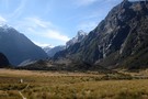
Fiery creek campsite
Photograph
•
Distance: 3.7km away
On the five passes route. Camping by Fiery creek. taken Jan 2010
More ▶︎
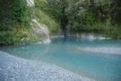
Red Pyke River confluence with the Pyke
Photograph
•
Distance: 3.8km away
The Red Pyke River meets the Pyke in the Pyke Gorge
More ▶︎
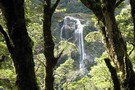
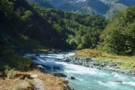
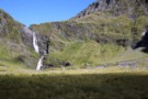
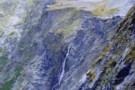
Beans Burn waterfall
Photograph
•
Distance: 4.1km away
On the five passes route. Waterfall mid Beans Burn. taken Jan 2010
More ▶︎
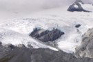
The Quarterdeck Glacier
Photograph
•
Distance: 4.2km away
Taken from the last rock outcrop at the base of the glacier at around about the 1860m mark, Mt French ...
More ▶︎
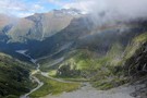
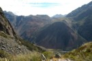
Park Pass and the Rockburn
Photograph
•
Distance: 4.3km away
the climb to Park Pass Glacier opens views down the Rockburn and the sidle to Lake Nerine
Feb 2013
More ▶︎
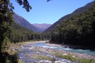
Beans Burn
Photograph
•
Distance: 4.4km away
On the five passes route. Upper Beans Burn valley from just below Fohn saddle. taken Jan 2010
More ▶︎
Fiery Col
Photograph
•
Distance: 4.5km away
taken from the 1200m highpoint on the Olivine Ledge
Feb 2013
More ▶︎
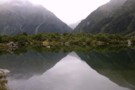
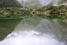
Early morning reflection
Photograph
•
Distance: 4.5km away
Taken from the top of Park Pass looking south towards the route into Lake Nerine
More ▶︎
View of the Rockburn from Park Pass Bivvy
Photograph
•
Distance: 4.5km away
As you ascend the Rockburn, perhaps as part of the Five Passes Walk, you can take advantage of a rock ...
More ▶︎
Rockburn - Lake Nerine - North Routeburn
Track
•
3 – 5 days. Medium. Loop track.
•
Distance: 4.5km away
A slightly shorter option to the 5 passes trip but of similar if not more difficulty. Can be done in ...
More ▶︎
Park Pass
Photograph
•
Distance: 4.5km away
On the five passes route. The upper Rock Burn from Park Pass. taken Jan 2010
More ▶︎
The Serpentine Range and the Three Passes
Article
•
Distance: 4.6km away
A six day trip around the Three Passes, including a traverse of the Serpentine Range instead of the North Route ...
More ▶︎
Down the Beansburn
Photograph
•
Distance: 4.6km away
looking down the Beansburn - on the climb to Fohn Pass
Feb 2013
More ▶︎
Gloomy Gorge
Photograph
•
Distance: 4.6km away
An 800 odd metre drop off seperates French Ridge from Gloomy Gorges floor.
More ▶︎
beansburn track
Track
•
3 – 5 days. Medium. Return via same track.
•
Distance: 4.7km away
a route that follows the beansburn valley. lake unknown can be reached from here.
times:
beansburn mouth-rock bivvy no 1 1-1.5 ...
More ▶︎
Mt Tantalus
Photograph
•
Distance: 4.7km away
Mt Tantalus over the Fohn Saddle. The Fohn Saddle is about the mid-point of the 5 passes tramp
More ▶︎
Fohn Lake
Photograph
•
Distance: 4.9km away
taken from above Fohn Pass, one possible route to the lake descends the gully on the right and sidles to ...
More ▶︎
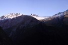
Mt French
Photograph
•
Distance: 4.9km away
Dawn reveals an overnight dusting of snow covers Mt French and the Quarterdeck glacier.
More ▶︎
Rock Formations on French Ridge
Photograph
•
Distance: 5.0km away
Interesting formations on the way up the ridge to the Quarterdeck glacier.
More ▶︎
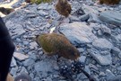
Mmmmmm tasty
Photograph
•
Distance: 5.1km away
While stopping for a rest on the way back down to the hut a flock of thirteen Keas drop in ...
More ▶︎
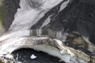
Snowbridge Gorge
Photograph
•
Distance: 5.1km away
Permanent snow remains in the gorge that the South branch of the Wilkin river flows.
More ▶︎
Pearl Flat to Scott's Bivvy
GPX file
•
Distance: 5.2km away
A new track has been cut through bush up the true left of the Matukituki river from Pearl Flat to ...
More ▶︎
Scotts Bivvy
Photograph
•
Distance: 5.2km away
Standing on top of the Bivvy. The head of the valley beyond
More ▶︎
Scotts Bivvy
Hut
•
Natural shelter (NA). Capacity: 2.
•
Distance: 5.2km away
A poor shelter for two people. Beware of the resident stream within the bivvy when it rains
More ▶︎
Snow Bridge Gorge
Photograph
•
Distance: 5.2km away
One of a couple of snow bridges that remain year round in here.
More ▶︎
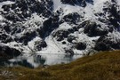
Lake Diana Reflections 2
Photograph
•
Distance: 5.3km away
The Snow Bridge Gorge gap between Mt Twilight and Mt Betsy Jane reflected in Lake Diana.
More ▶︎
Wilkin Valley Track
Track
•
2 – 5 days. Easy/medium. Return by the same track.
•
Distance: 5.3km away
This stunning track is commonly tramped in conjunction with the Gillespie Pass Circuit or with the Rabbit Pass/East Matukituki traverse, ...
More ▶︎
Track to North Branch lakes
Photograph
•
Distance: 5.3km away
Shortly before reaching the Disappearing Tarn
More ▶︎
Where do rivers come from?
Photograph
•
Distance: 5.3km away
Wilkin North Branch toward upper lakes
More ▶︎
Lake Diana Reflections
Photograph
•
Distance: 5.3km away
The lower slopes of Mt Betsy Jane and Mt Pollux reflected in Lake Diana.
More ▶︎
Lake Lucidus Morain Walls and the Upper Wilkin Valley
Photograph
•
Distance: 5.3km away
Mts Juno and Vesta tower over the massive morain which conceals Lake Lucidus.
More ▶︎
Lake Dianna
Photograph
•
Distance: 5.4km away
The 1st of the three main lakes of the North branch of the Wilkin it is perhaps the least stunning ...
More ▶︎
Alabaster Pass from the Olivine ledge
Photograph
•
Distance: 5.4km away
Looking from the ledge at the Olivine river and the flats on the river at the base of Alabaster Pass. ...
More ▶︎
Lake Lucidus
Photograph
•
Distance: 5.4km away
Located beneath Mt Caster and Apollo Peak, Lucidus is a great example of a lateral morain lake.
More ▶︎
The Disappearing Tarn and Apollo Peak Reflections
Photograph
•
Distance: 5.4km away
The first mini lake encountered is the small Disappearing tarn.
More ▶︎
Scotts Rock Biv
Rock bivouac
•
Distance: 5.5km away
Located at the head of the Matukituki River West Branch, beyond Pearl Flat.
The biv is 500m upstream of the upper ...
More ▶︎
Fohn lake - Mt.Aspiring NP NZ
Photograph
•
Distance: 5.5km away
Along the Five Passes route and below Fohn saddle. The lake sits above the Olivine ledge. Fine weather at lunchtime.
March ...
More ▶︎
Red Mountain
Photograph
•
Distance: 5.5km away
Red Mountain from the descent from Stag Pass; the Simonin Flats are visible alongside the upper Pyke River with Kea ...
More ▶︎
Sunset from Fohn Lake
Photograph
•
Distance: 5.5km away
looking W from the knoll above Fohn Lake
Feb 2013
More ▶︎
Sunset on Sunset Peak
Photograph
•
Distance: 5.5km away
deepening colours as the sun sets
Feb 2013
More ▶︎
Fohn Lake sunset
Photograph
•
Distance: 5.6km away
Feb 2013. Sun setting behind the Bryneira Range as seen from point 1501
More ▶︎
Lake Lucidus from Atop the Morain Wall
Photograph
•
Distance: 5.6km away
After reaching Lake Lucidus its well worth fording the outlet stream and scrambling up the South morain for a stunning ...
More ▶︎
Fohn Lake
Photograph
•
Distance: 5.6km away
relaxing in the early evening - a great camp beside the tarn and below the aptly named Sunset Peak
More ▶︎
French Ridge Hut
Photograph
•
Distance: 5.6km away
This NZAC hut is located on the summer snowline near Mount Aspiring.
More ▶︎
French Ridge
Track
•
2 – 4 days. Medium. Return via same track.
•
Distance: 5.6km away
A steep climb to the snowline in the West Matukituki.
More ▶︎

Haast to The Divide
GPX file
•
Distance: 5.7km away
Andrew Barker's traverse 2009. From Pleasant Flat in the Haast to The Divide via Mt Aspiring National Park.
More ▶︎
Fohn Lake
Photograph
•
Distance: 5.7km away
On the five passes route. Fohn lake with Sunset Peak (1800m) behind it. taken Jan 2010
More ▶︎
Looking south from Sysiphus Peak
Photograph
•
Distance: 5.8km away
The Matukituki East Branch winds its way down to meet the West Branch, where we started this walk yesterday. It's ...
More ▶︎
Rainbow Stream
Photograph
•
Distance: 5.8km away
Probably at about 1000m here, 500m above Aspiring Flats visible below.
We faffed around somewhere near here and lost a couple ...
More ▶︎
Sisyphus Peak from Wilmot Saddle
Photograph
•
Distance: 5.8km away
Still 200m to go.
Sisyphus Peak (1859m) from Wilmot Saddle (1682m).
More ▶︎
Aspiring Flat and Sisyphus Peak
Track
•
3 days. Medium. Return via same track.
•
Distance: 5.8km away
A one and two-half day tramp up the East Matukituki to overnight in Aspiring Flats, with a day trip up ...
More ▶︎
Rock of Ages bivvy - Mt.Aspiring Flats
Photograph
•
Distance: 5.9km away
A short distance from the East Matukituki, through which flows Kitchener stream is Aspiring Flats. Coveniently located is a rock ...
More ▶︎
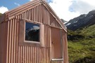
French Ridge Hut
Hut
•
Serviced Alpine Hut (NZAC). Capacity: 20.
•
Distance: 6.0km away
This new hut is located on the summer snowline on French Ridge, near the head of the Matukituki Valley West ...
More ▶︎
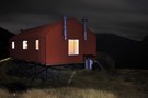
French Ridge Hut at night
Photograph
•
Distance: 6.0km away
210 second exposure @ f / 4.0, 17mm
More ▶︎
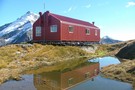
French Ridge Hut Reflection
Photograph
•
Distance: 6.0km away
Reflection of the French Ridge Hut in the tarn on a fine April day.
More ▶︎
Picton to Aspiring
GPX file
•
Distance: 6.0km away
An aborted alpine traverse. Picton to West Cape, but aborted at Aspiring due to real world emergencies back home. Posted ...
More ▶︎
Rock of Ages Bivouac
Rock bivouac
•
Distance: 6.1km away
An overhang above the Kitchener River and Aspiring Flats, near the Matukituki East Branch. Room to sleep 10, although exposed ...
More ▶︎
North Wilkin from Top Forks Hut
Photograph
•
Distance: 6.1km away
Wilkin River north branch, from the verandah at Top Forks Hut
More ▶︎
Top Forks Hut (Wilkin)
Hut
•
Standard Hut (DOC). Capacity: 16.
•
Distance: 6.1km away
There are two huts at Top Forks (total 16 bunks, stove / fireplace, firewood available, tank water). The smaller is ...
More ▶︎
Rabbit Pass - Wilkin to East Matukituki
Track
•
1 day. Hard. One way.
•
Distance: 6.1km away
A fair weather route linking the upper Wilkin valley to the head of the East Matukituki. Two dangerous climbs are ...
More ▶︎
Top Forks Hut (Wilkin)
Photograph
•
Distance: 6.2km away
Top Forks Hut, in the Wilkin Valley. The last hut north of the infamous rabbit pass.
More ▶︎
Mount Avalanche avalanche
Photograph
•
Distance: 6.2km away
Viewed from the French Ridge Track. Avalanches from here, from Rob Roy Peak, or from peaks across the valley can ...
More ▶︎
Gloomy Gorge
Photograph
•
Distance: 6.2km away
Viewed from the French Ridge Track, with Mount Avalanche in the background.
More ▶︎

The Olivine ledge from our bivvy at sunset.
Photograph
•
Distance: 6.3km away
The Fohn Lakes are above and to the left here with the outlet streams dropping across the ledge. The ledge ...
More ▶︎
Head of the Matukituki Valley West Branch
Photograph
•
Distance: 6.4km away
Viewed from French Ridge Track.
More ▶︎
Liverpool Hut
Photograph
•
Distance: 6.4km away
Viewed from the French Ridge Track across the valley
More ▶︎
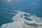
Waterfall Flat from ontop of the Waterfall Face
Photograph
•
Distance: 6.4km away
Having made it to the top you are gifted views such as this.
More ▶︎
Upper Wilkin South Branch
Photograph
•
Distance: 6.4km away
Taken from above the Waterfall Face looking South West towards Pickelhaube. Pearson Saddle is the low grassy bit beneath Pickelhaube ...
More ▶︎
to Lake Nerine
Photograph
•
Distance: 6.4km away
on the sidle to Lake Nerine, looking back to Park Pass Glacier
More ▶︎
Looking back towards Park Pass
Photograph
•
Distance: 6.5km away
It is a steep snowgrass sidle from Park Pass to this point but the view is rewarding
More ▶︎
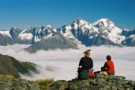
Sunset Peak
Photograph
•
Distance: 6.5km away
panorama from the summit of Sunset Peak - looking S to E across Fohn Pass and Lake and Fiery Col ...
More ▶︎
Sunset panorama
Photograph
•
Distance: 6.5km away
panorama from Sunset Peak, looking NE to NW.
From Skippers Range, across Lake Wilmot & Olivine River, Terminal Peak to the ...
More ▶︎
Merkl Glacier
Photograph
•
Distance: 6.5km away
photo taken from the easily reached Sunset Peak, looking NE. Feb 2013
More ▶︎
Tramping in the Wilkin Waterfall valley
Photograph
•
Distance: 6.5km away
Approaching the dreaded 200m Wilkin Waterfall face, we're dwarfed by the 400m waterfall tumbling off the North slopes of Mt ...
More ▶︎
The Wilkin Waterfall Face
Photograph
•
Distance: 6.6km away
The route to Rabbit Pass climbs up the cliff to the right of the falls.
More ▶︎
Closeup of the Wilkin Waterfall Route
Photograph
•
Distance: 6.6km away
Hard to get a good angle of this! The route initially goes up the middle of the 2nd to the ...
More ▶︎
Waterfall Face, Wilkin River
Photograph
•
Distance: 6.6km away
Misty rain obscures the infamous Waterfall Face
More ▶︎
Waterfall Flat from above
Photograph
•
Distance: 6.6km away
Scungy weather continues to obscure the views, topped by a raging wind....
More ▶︎
Waterfall Flat
Photograph
•
Distance: 6.7km away
Looking over the South branch of the Wilkin towards the Wilkin Waterfall Face and Mt Taurus.
More ▶︎
French Ridge Track
Photograph
•
Distance: 6.9km away
The French Ridge Track features tangled roots, steep gradients, and clambering down rock walls.
More ▶︎
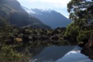
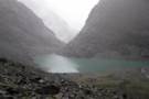
A tarn on the way to Lake Nerine
Photograph
•
Distance: 7.1km away
This tarn is a very attractive place to stop for a while on the way to Lake Nerine. While it ...
More ▶︎
Views from Liverpool hut
Photograph
•
Distance: 7.2km away
The triangle of Mt Aspiring pokes above the skyline to the left, with Mt French and French Ridge in the ...
More ▶︎
West Matukituki from Liverpool hut
Photograph
•
Distance: 7.2km away
Looking down valley from the hut, Rob Roy Peak dominates above Shovel Flat, the Cascade Saddle is visible in the ...
More ▶︎
Liverpool hut
Photograph
•
Distance: 7.2km away
The new (2009) 10 bunk Liverpool hut beneath Mt Barff.
More ▶︎
Liverpool Hut
Photograph
•
Distance: 7.2km away
Liverpool Hut commands and excellent view down the West Matukituki Vallet
More ▶︎
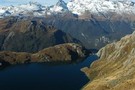
Lakelet in the Humboldt Mountains - Mt.Aspiring NP NZ.
Photograph
•
Distance: 7.3km away
Perched high above the Rockburn valley floor, near to Lake Nerine only a little northward toward Park Pass.
More ▶︎
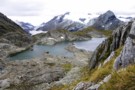
Unnamed lake under Angle Peak
Photograph
•
Distance: 7.3km away
This unnamed lake lies on the south side of Angle Peak, which is to the east of the Four Brothers ...
More ▶︎
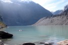
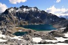
Lake Castalia
Photograph
•
Distance: 7.4km away
Completely ringed by rock walls, numerous waterfalls tumble off the towering Mercury Peak glaciers to feed Lake Castalia, the North ...
More ▶︎
Lake Castalia from the North
Photograph
•
Distance: 7.4km away
Sidling around the Eastern shore of the lake takes you into the upper reaches of the Castalia valley, a sea ...
More ▶︎
View from Pearson Saddle
Photograph
•
Distance: 7.4km away
Looking West into the Pearson River valley with a distant glimpse of the Waiatoto valley.
More ▶︎
Rabbit Pass from Pearson Saddle
Photograph
•
Distance: 7.4km away
Looking from a great spot for lunch on the saddle towards the pass.
More ▶︎
Big Bay - Pyke - Hollyford Road-end Route
GPX file
•
Distance: 7.4km away
Big Bay - Pyke - Hollyford Road-end Route as tramped by us in May 2012 and recorded with Garmin GPS60csx
More ▶︎
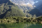
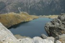
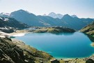
Lake Nerine
Photograph
•
Distance: 7.5km away
The first view you get of Lake Nerine as you cross the saddle by Point 1594.
Jan 2017
More ▶︎
Liverpool Hut From Behind
Photograph
•
Distance: 7.5km away
view of liverpool hut from behind ..mt apiring to the Left
More ▶︎
Liverpool Hut
Photograph
•
Distance: 7.5km away
-Makeshift Campsite 200 meters from Liverpool Hut
-Hut was full so we could not sleep there but we did cook there
More ▶︎
Liverpool Hut toilet
Photograph
•
Distance: 7.5km away
View from the drop toilet at Liverpool Hut
More ▶︎
Liverpool Hut
Hut
•
Serviced Alpine Hut (DOC). Capacity: 10.
•
Distance: 7.5km away
Located on the steep lower slopes of Mount Barff, this hut offers striking views and a route to the Arawhata ...
More ▶︎
Lake Alabaster Hut
Hut
•
Serviced Hut (DOC). Capacity: 26.
•
Distance: 7.7km away
Second hut on the Hollyford Track.
More ▶︎
Lake Alabaster from the South
Photograph
•
Distance: 7.7km away
Taken from the beach about 5 minutes from the Lake Alabaster hut.
More ▶︎
Camp at Lake Nerine
Photograph
•
Distance: 7.8km away
This has to be every tramper's dream. A camp at Lake Nerine in perfect windless conditions
More ▶︎
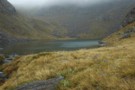
Lake Unknown
Photograph
•
Distance: 7.9km away
Lake Unknown lies high between the Beans Burn & the Rockburn. The Dart Valley is visible behind about 750 meters ...
More ▶︎
Rabbit Pass
Photograph
•
Distance: 8.0km away
A view of Rabbit Pass from just below the drop off point. In the distant is the route from Waterfall ...
More ▶︎

Birthplace of Rivers
Photograph
•
Distance: 8.0km away
From such humble beginnings does the South branch of the Wilkin start.
More ▶︎
Theatre Flat from above
Photograph
•
Distance: 8.0km away
Looking back down at Theatre Flat from the lip of the hanging valley that holds lake Nerine
More ▶︎
A fresh look at the descent to Lake Nerine.
Photograph
•
Distance: 8.2km away
If visiting the lake from Park Pass it is inevitable you will find yourself at the top of this slope ...
More ▶︎

Mind the little bitches! Don`t forget some anti-sandfly-shit!
Photograph
•
Distance: 8.2km away
On this pic u can see just a little of them. After a few days at "camp sandfly" the bitches ...
More ▶︎
Lake Nerine
Photograph
•
Distance: 8.2km away
Looking back at Lake Nerine from the ridge at its head. Mt Earnslaw in the distance
More ▶︎
Pyke - Big Bay Route
Track
•
3 – 4 days. Hard. One way.
•
Distance: 8.2km away
A more challenging extension to the Hollyford Track following old roads, rivers, lake edges, and beaches.
More ▶︎
The East Matukituki from Rabbit Pass - a video
Video
•
Distance: 8.2km away
Shot on my point and shoot digital camera, hopefully gives some idea of the amazing view from this spot!
More ▶︎
The East Matukituki from Rabbit Pass
Photograph
•
Distance: 8.2km away
From just past the pass looking South over the valley from some 600 metres above the valley floor.
More ▶︎
The Olivine river - Mt.Aspiring NP
Photograph
•
Distance: 8.2km away
Several hundred metres below the Olivine ledge on the river. A little downstream of the confluence with Sunset Ck. That ...
More ▶︎
Rabbit Pass from under Lois Peak
Photograph
•
Distance: 8.2km away
Looking West along the cliff top towards Rabbit Pass, Pickelhaube and the Beauty Ridge above, the East Matukituki waterfall below.
More ▶︎
Rockburn Skyline
Photograph
•
Distance: 8.2km away
panorama of the Rockburn from Park Pass Glacier to Theatre Flat - from the outlet of Lake Nerine
Feb 2013
More ▶︎
Descent of the Matukituki Cliff
Photograph
•
Distance: 8.3km away
Taken from the top of the cliff the route zigzags steeply down on the left of frame for about 20m ...
More ▶︎
The tops of the Darran Mountains - Fjordland NZ
Photograph
•
Distance: 8.4km away
The exit from the Lake Nerine basin when heading to North Col overlooks the lower end of Hidden Falls Ck ...
More ▶︎
East Branch Matukituki visible through the rain
Photograph
•
Distance: 8.4km away
Demon descent in the conditions
More ▶︎
Joe Glacier
Photograph
•
Distance: 8.4km away
A view of the head of the Joe river and the remains of the Joe glacier in Aspiring National Park. ...
More ▶︎
New Dredge Lake
Photograph
•
Distance: 8.4km away
The new lake at Dredge Flat on the Dart River.
More ▶︎
East Matukituki Cliff Route
Photograph
•
Distance: 8.5km away
Not a good picture of the route, but the best I have! The descent down starts in the sunny bit ...
More ▶︎
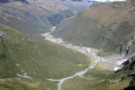
Theatre Flat
Photograph
•
Distance: 8.6km away
Half way up the Rockburn is the giant Theatre Flats. Lake Nerine is at the top of the bluffs at ...
More ▶︎
Lake Alabaster from the North
Photograph
•
Distance: 8.6km away
Taken from the Northern head of the lake looking South. 3 hours of wading in the lake awaits to reach ...
More ▶︎
Theatre Flat
Photograph
•
Distance: 8.7km away
Approaching Theatre Flat from down valley. On a nice day it's a pleasant place to camp, not so much this ...
More ▶︎
Tutuko & Madeline
Photograph
•
Distance: 8.8km away
Looking across at Mt Tutuko and Madeline across a cloud filled Hollyford Valley. This is during a rest on the ...
More ▶︎
Bridge in the Rockburn
Photograph
•
Distance: 8.8km away
This fine bridge provides an easy crossing of the Rockburn just below Theatre Flat
More ▶︎
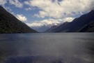
Hollyford Valley
Photograph
•
Distance: 8.9km away
thick cloud fills the Hollyford Valley as we sidle on the 1600m contour to North Col (Prospector Peak in the ...
More ▶︎
Campsite in beech forest beside the Forgotten river
Photograph
•
Distance: 8.9km away
After a slower than expected journey down from the Olivine ledge and along the river to Olivine Flats, we crossed ...
More ▶︎
View north from Nereus Peak
Photograph
•
Distance: 9.1km away
The ridge east of Nereus Peak summit can be reached by a straight forward climb from North Col. Looking north ...
More ▶︎
Shovel Flat in the West Matukituki
Photograph
•
Distance: 9.3km away
A beutiful spot with heaps of great camping sites, French Ridge is the major ridge descending to the valley floor ...
More ▶︎
Forgotten River's blue pool
Photograph
•
Distance: 9.3km away
The Forgotten River leaves it's gorge before the confluence with the Olivine River through the Blue Pool
More ▶︎
Wilkin River
Track
•
3 days. Medium. Return via same track.
•
Distance: 9.3km away
A 3 day tramp from Kerin Forks hut to the Wonderland Valley. Following the Wilkin River upstream. We took a ...
More ▶︎
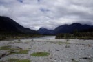
Pyke Crossing
Photograph
•
Distance: 9.5km away
A large braided river crossing, it was 3 or 4 seperate water channels seperated by gravel islands when this photo ...
More ▶︎
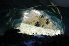
Ice Cave
Photograph
•
Distance: 9.6km away
Remnants of winter snow fall melted from underneath by the North Routeburn. Taken from just below North Col.
More ▶︎
Rabbit Pass is up there
Photograph
•
Distance: 9.6km away
View from the East Branch Matukituki River of the descent from Rabbit Pass
More ▶︎
Pyke Airstrip
Photograph
•
Distance: 9.6km away
The last good camping to be had here if you push on past Pyke Crossing.
More ▶︎
Head wall of Wonderland Valley
Photograph
•
Distance: 9.8km away
Taken in Mar 2006 after bush bashing up the true right of Wonderland stream. No trail just picking a way ...
More ▶︎
Hidden Falls Creek
Photograph
•
Distance: 10.0km away
Most of the creek above the big bend; from between North Col & Serpentine Saddle
More ▶︎