Nearby
Elliott Bivvy Dec 2013
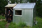
Elliott Bivvy
Hut
•
Basic Hut/Bivvy (DOC). Capacity: 2.
•
Distance: less than 100m away
This newish bivvy is at the site of an older demolished hut. It is on the East - West route ...
More ▶︎
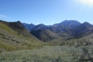
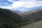
Elliott Stream
Photograph
•
Distance: 1.4km away
Descending into Elliott Stream ... peaks in the distance offering promise ...
More ▶︎
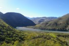
Clarence River
Photograph
•
Distance: 3.3km away
The mighty Clarence - from the start of the Molesworth East-West route above Seymour Hut. 1 or 3 crossings are ...
More ▶︎
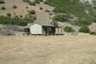
Seymour / Forbes Hut
Hut
•
Standard Hut (DOC). Capacity: 10.
•
Distance: 3.8km away
Hut on the Clarence River near the Seymour River, and at the end of the 4WD route over Blind Saddle. ...
More ▶︎
East West Route
Track
•
5 – 6 days. Medium. One way.
•
Distance: 4.4km away
A long trail through remote, desolate high country between the Clarence River and Molesworth Recreation Reserve.
More ▶︎
Molesworth Recreation Reserve
Place
•
Reserve. 1807.87km2.
•
Distance: 4.9km away
An iconic high country station located behind the Kaikoura Ranges.
More ▶︎
Lake McRae Hut
Hut
•
Standard Hut (DOC). Capacity: 6.
•
Distance: 5.7km away
This hut dates from 1970 and was originally an NZFS four bunker. In Feb/March 2012 the hut received a major ...
More ▶︎
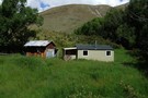
Lake McRae huts Dec 2013
Photograph
•
Distance: 5.7km away
This photo shows the two huts at Lake McRae. In a straight line they are located almost a km west ...
More ▶︎
East-West Route: 3 day circuit east of Molesworth
Article
•
Distance: 5.7km away
A circuit taking in Lake McRae, Carters Saddle and then a descent into the head of the Awatere via an ...
More ▶︎
Horse Flat Hut
Hut
•
Shelter (DOC).
•
Distance: 6.1km away
An historic iron rabbiters' hut on river flats in the Clarence Reserve. The carved door indicates the hut was built ...
More ▶︎
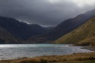
Lake McRae
Photograph
•
Distance: 9.2km away
Looking north from Robinson Saddle, upvalley towards Lake McRae
More ▶︎