Nearby
Specimen Point Hut
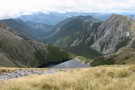
Old Ghost Road
Track
•
3 – 5 days. Medium. One way.
•
Distance: less than 100m away
A four or five day tramp from the Lyell Campsite(off SH6 in the Buller Gorge) to the Mokihinui road end ...
More ▶︎
Old Ghost Road
GPX file
•
Distance: 162m away
A GPS track of the Old Ghost Road November 2017
More ▶︎
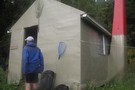
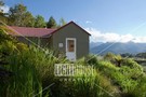
Specimen Point Hut
Hut
•
Standard Hut (NA). Capacity: 12.Bookings required.
•
Distance: 174m away
Specimen Point hut is situated on a high point with a commanding view over a stretch of the Mokihinui river.
The ...
More ▶︎
Old Ghost Road
Track
•
4 – 5 days. Easy/medium. One way.
•
Distance: 2.1km away
This new trail links the ghost town of Lyell with the Mokihinui River. The first section is open from 2 ...
More ▶︎
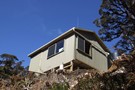
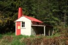
Mokihinui Forks Hut
Hut
•
Basic Hut/Bivvy (DOC). Capacity: 10.
•
Distance: 2.1km away
Mokihinui Forks Hut sits over the south branch of the Mokihinui River, just before it meets the north branch.
The hut ...
More ▶︎
Mokihinui Forks Hut
Photograph
•
Distance: 2.1km away
Mokihinui Forks Hut sits over the south branch of the Mokihinui River, just before it meets the north branch.
More ▶︎
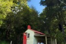
Mokihinui Forks Hut - renovated
Photograph
•
Distance: 2.1km away
In 2013 DOC doubled the size of Mok Forks Hut which includes more bunks inside a new foyer. Total of ...
More ▶︎
Goat Creek hut Sept 2009
Photograph
•
Distance: 7.7km away
A charming hut situated on the TR of the South Branch of the Mokihinui River at the confluence with Goat ...
More ▶︎
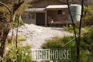
Goat Creek hut
Hut
•
Basic Hut/Bivvy (DOC). Capacity: 4.
•
Distance: 7.7km away
A charming hut situated on the TR of the South Branch of the Mokihinui River at the confluence with Goat ...
More ▶︎
Goat Creek Hut (DOC)
Photograph
•
Distance: 7.7km away
In 2013 this historic hut built in 1957 was cleaned up. The old graffiti wall is still intact, and the ...
More ▶︎
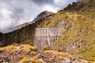
Boscawen Saddle, Rough Creek route
Article
•
Distance: 7.7km away
A description of a weekend tramp up the Nina River, over Boscawen Saddle, sidling to Robinson Saddle, down one branch ...
More ▶︎
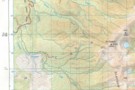
Mt Glasgow track map
Photograph
•
Distance: 9.6km away
Approximate position of track plotted on copy of NZ Topo 50 map. Crosses indicate position plotted from a GPS reading
More ▶︎
View in easterly direction from summit of Mt Glasgow
Photograph
•
Distance: 9.6km away
View in easterly direction from summit of Mt Glasgow. Taken 04/02/2012
More ▶︎
Mt Glasgow 1424m
Track
•
1 – 2 days. Medium. Return via same track.
•
Distance: 9.6km away
A superb day walk in behind the sleepy village of Seddonville.
More ▶︎