Nearby
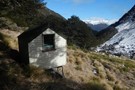
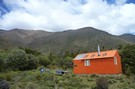
Bull Paddock Creek Hut
Bull Paddock Creek Track
Track
•
1 – 3 days. Medium. Return by the same track.
•
Distance: less than 100m away
Access To Bull Paddock Creek Biv from The Wairau river, this track follows Sand Fly Stream before dropping Bull Paddock ...
More ▶︎
Bull Paddock Creek Track
GPX file
•
Distance: less than 100m away
GPS file of track from Bull Paddock Creek Biv to the Wairau River
More ▶︎
Mid Silverstream Hut
Hut
•
Standard Hut (DOC). Capacity: 5.
•
Distance: 4.2km away
Located on Silverstream, off the Branch River.
Note that Silverstream Biv is not upstream of this hut, but is at the ...
More ▶︎
Lost Stream Bivvy
Hut
•
Basic Hut/Bivvy (DOC). Capacity: 2.
•
Distance: 4.3km away
Located on Lost Stream beneath the Raglan Range, Leatham Conservation Area.
More ▶︎
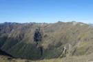
View over Silverstream and down Raglan Range
Photograph
•
Distance: 4.9km away
I took this photo looking generally southward when high on the Raglan Range. I was heading to Silverstream Bivvy and ...
More ▶︎
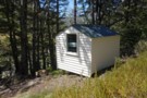
Silverstream Bivvy Jan 2019
Photograph
•
Distance: 5.8km away
A nice Marlborough biv in the Branch catchment of the Raglan Range that gets few visitors.
More ▶︎
Silverstream Bivvy
Hut
•
Basic Hut/Bivvy (DOC). Capacity: 2.
•
Distance: 5.8km away
Weatherboard and iron biv located near the treeline on the Raglan Range. The biv is not on Silverstream itself but ...
More ▶︎
Top Misery Hut
Hut
•
Standard Hut (DOC). Capacity: 4.
•
Distance: 5.8km away
Hut in a basin beneath the Raglan Range, Leatham Conservation Area.
More ▶︎
Red Hills Ridge Traverse
GPX file
•
Distance: 7.9km away
Traverse of the Red Hills Ridge beginning from the Red Hills car park, returning via Mt Ellis, Hunters Hut, Porters ...
More ▶︎
Siberia Hut (Marlborough)
Hut
•
Standard Hut (DOC). Capacity: 6.
•
Distance: 8.3km away
Leatham Conservation Area
More ▶︎
Greig's Hut
Hut
•
Standard Hut (DOC). Capacity: 14.
•
Distance: 9.0km away
This hut is located in the Raglan Range although the area looks more like Canada than Marlborough. It is surrounded ...
More ▶︎
St Arnaud Range Track
Track
•
1 day. Medium. Return by the same track.
•
Distance: 9.3km away
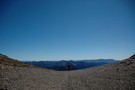
This walk climbs steadily through beech forest to a height of over 1650 metres.
Above the bushline (at 1400 m), ...
More ▶︎
Picton to Aspiring
GPX file
•
Distance: 9.6km away
An aborted alpine traverse. Picton to West Cape, but aborted at Aspiring due to real world emergencies back home. Posted ...
More ▶︎
Bottom Misery Hut
Hut
•
Standard Hut (DOC). Capacity: 6.
•
Distance: 9.8km away
Hut with balcony at the junction of Misery and Branch Streams in the Leatham Conservation Area.
More ▶︎
Walking the length of the Richmond Ranges
Track
•
7 – 14 days. Medium/hard. One way.
•
Distance: 9.9km away
A 7-14 day walk along the spine of the Richmond Ranges. Alpine tops, crumbling ridgelines, untracked bush & scrub, boulders ...
More ▶︎
Parachute Rocks Track
Photograph
•
Distance: 9.9km away
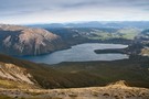
View of Lake Rotoiti from point 1738
More ▶︎
Mount Richmond Forest Park
Place
•
Conservation Park. 1660.00km2.
•
Distance: 9.9km away
A wedge of land at the base of the Marlborough Sounds, south of Nelson and north of the Wairau River, ...
More ▶︎