Nearby
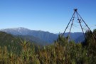
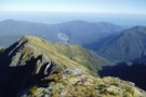
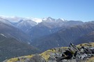
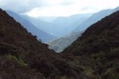
Mt Bowen from Fraser Peak March 2013
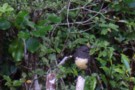
SI Bush Robin
Photograph
•
Distance: less than 100m away
This friendly bird kept me company at Explorer hut the couple of nights I was there recently. It would come ...
More ▶︎
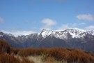
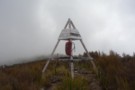
Looking SW from Mt Diedrichs May 2013
Photograph
•
Distance: less than 100m away
This photo taken from beside the trig beacon on the summit of Mt Diedrichs 1084m looks SW over the Hokitika ...
More ▶︎
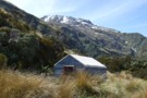
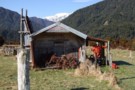
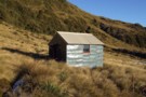
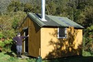
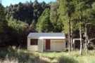
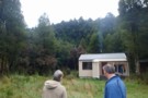
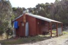
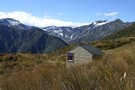
Explorer Hut
Hut
•
Basic Hut/Bivvy (DOC). Capacity: 4.
•
Distance: less than 100m away
A small hut located near Douglas Saddle.
Easiest access is from the Mikonui valley. None of the routes are recommended in ...
More ▶︎
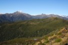
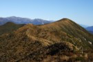
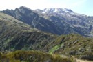
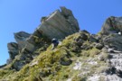
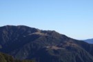
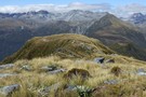
View SE from Bald Hill Range June 2013
Photograph
•
Distance: less than 100m away
This picture was taken from the crest of the Bald Hill Range NE of Bald Hill.
The tussock and low ...
More ▶︎
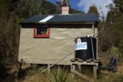
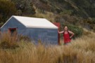
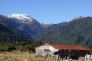
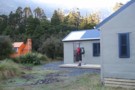
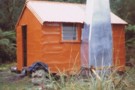
Explorer hut Sept 2007
Photograph
•
Distance: less than 100m away
Explorer hut Douglas Saddle. Mikonui River/Doctors Creek (a tributary of the Hokitika River)
More ▶︎
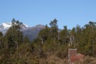
Remarkable Peak
Photograph
•
Distance: 1.3km away
This photo shows Remarkable Peak 1790m in spring conditions. It is the tooth like peak centre picture. The pic was ...
More ▶︎
Black Hut Totara Valley & beyond
Photograph
•
Distance: 1.3km away
This July shot taken from beside the Totara Valley road shows Black Hut. The higher country in the back ground ...
More ▶︎
Looking SW along the Bald Hill Range June 2013
Photograph
•
Distance: 1.3km away
This photo shows the easy tussock tops of the Bald Hill Range. Bald Hill is the tussocky high point down ...
More ▶︎
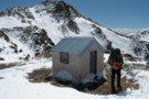
Mikonui Spur Bivvy
Hut
•
Basic Hut/Bivvy (DOC). Capacity: 2.
•
Distance: 2.9km away
A traditional forestry bivvy that has braved many a Tasman Sea storm, on an exposed ridge top above the Mikonui ...
More ▶︎
Looking up Mikonui Spur Dec 2010
Photograph
•
Distance: 2.9km away
This pic is taken from the track on the spur below the biv and looks up past the biv in ...
More ▶︎
Mikonui Spur biv Dec 2010
Photograph
•
Distance: 2.9km away
A pic of the biv with Mt Bowen behind to the SE.
More ▶︎
Mikonui Spur biv Nov 2007
Photograph
•
Distance: 2.9km away
The subject J H & photographer, not me in this case, Horse G are sometimes tramping companions. They, like myself, ...
More ▶︎
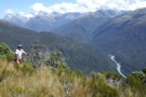
Route to Healey Ck hut from Mikonui Flat
Photograph
•
Distance: 3.6km away
From the track start on the Flat it's a bit over 2hrs of up hill then 20 minutes down to ...
More ▶︎
Old shed & beyond. Mikonui Flat July 2010
Photograph
•
Distance: 3.7km away
This old shed is next to the old homestead on Mikonui Flat.
Beyond the shed is the Mikonui River and then ...
More ▶︎
Historic Homestead Mikonui Flat Sept 2007
Photograph
•
Distance: 3.7km away
This small old farm dwelling is on the TR of the Mikonui flats & is referred to as "The Old ...
More ▶︎
Healey Spur Feb 2014
Photograph
•
Distance: 3.8km away
This photo shows the last steep bit of Healey Spur before reaching the relatively easy going of Galena Ridge at ...
More ▶︎
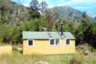
Mikonui Flat hut May 2008
Photograph
•
Distance: 4.1km away
This is the first of the DOC huts when heading up the Mikonui River. It is on the TL about ...
More ▶︎
Mikonui Flat hut
Hut
•
Standard Hut (DOC). Capacity: 6.
•
Distance: 4.1km away
This is the first of the DOC huts when heading up the Mikonui River. It is on the TL about ...
More ▶︎
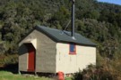
Healey Creek hut May 2008
Photograph
•
Distance: 4.3km away
A tidy four bunker toward the head of Healey Creek a Mikonui River tributary. The hut is on a tussock ...
More ▶︎
Healey Creek hut
Hut
•
Basic Hut/Bivvy (DOC). Capacity: 4.
•
Distance: 4.3km away
A tidy four bunker toward the head of Healey Creek a Mikonui River tributary. The hut is on a tussock ...
More ▶︎
Whitcombe Pass & Butler Saddle
Article
•
Distance: 5.0km away
route guide attached by for Hokitika Gorge to Erewhon via Whitcombe Pass & Butler Saddle. The guide was written by ...
More ▶︎
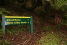
Which Way?
Photograph
•
Distance: 5.1km away
I would suggest staying away from the flood route unless you have to as its very steep and long!
More ▶︎
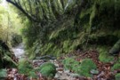
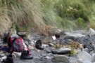
Typical track on the tramp
Photograph
•
Distance: 5.1km away
The typical looking track on the tramp, if there has been rain/or is raining expect to get a bit of ...
More ▶︎
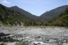
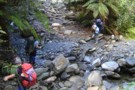
View of the hills that lead to the huts
Photograph
•
Distance: 5.1km away
the crossing is slightly to the left of the middle
More ▶︎
Historic Cedar Flats Hut
Photograph
•
Distance: 5.1km away
A well maintained old hut. 2 bunks
More ▶︎
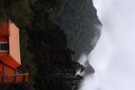
Cedar Flats Hot Springs
Photograph
•
Distance: 5.1km away
Perfect hot springs in a secluded hokitika valley. Holds upto 6 people.
More ▶︎
Whitcombe Pass
Track
•
5 – 7 days. Medium/hard. One way.
•
Distance: 5.6km away
This route follows the famous journey by John Henry Whitcombe and the Swiss guide Jakob Lauper across the Main Divide ...
More ▶︎
Rapid Creek hut May 1975
Photograph
•
Distance: 5.6km away
An older pic of the hut after it had got its first replacement chimney. These days the hut has a ...
More ▶︎
Rapid Creek hut June 2008
Photograph
•
Distance: 5.6km away
This is a four bunker on the TL of the Hokitika River not far below the junction with the Whitcombe ...
More ▶︎
Rapid Creek hut
Hut
•
Basic Hut/Bivvy (DOC). Capacity: 4.
•
Distance: 5.6km away
This is a four bunker on the TL of the Hokitika River not far below the junction with the Whitcombe ...
More ▶︎
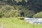
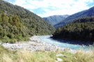
Whitcombe River gorge
Photograph
•
Distance: 6.4km away
Whitcombe River gorge, upstream from Frew Hut
More ▶︎
Frew Hut
Hut
•
Standard Hut (DOC). Capacity: 10.
•
Distance: 6.4km away
Frew Hut (sleeps 10 on 2 platforms, matresses, tank & creek water, stove) is a modern tramping hut on river ...
More ▶︎
Frew Hut
Photograph
•
Distance: 6.4km away
Frew Hut, in the Whitcombe River valley, Westland
More ▶︎
Whitcombe River from Frew Hut
Photograph
•
Distance: 6.4km away
Whitcombe River from Frew Hut, Westland
More ▶︎

Route Guide: Otira to Mt Cook Village (pt 2)
Track
•
12 – 21 days. Hard. One way.
•
Distance: 6.4km away
One possible route down the main divide from Otira on the Arthur's Pass road to Mt Cook Village.
Otira Hotel ...
More ▶︎

Route Guide: Otira to Mt Cook Village (pt 1)
Track
•
12 – 21 days. Hard. One way.
•
Distance: 6.4km away
One possible route down the main divide from Otira on the Arthur's Pass road to Mt Cook Village.
Otira Hotel to ...
More ▶︎
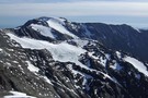
Mt Beaumont (2131m) April 2012
Photograph
•
Distance: 6.4km away
This pic looks at Mt Beaumont from the south and was taken from the crest of the Lange Range while ...
More ▶︎
Frews Hut
Photograph
•
Distance: 6.5km away
8/10 bunker,like the Hilton after Frews Bivvy.Overlooks the Whitcombe River & 200m west of Frews
Creek.We saw a pair of ...
More ▶︎
Picton to Aspiring
GPX file
•
Distance: 6.5km away
An aborted alpine traverse. Picton to West Cape, but aborted at Aspiring due to real world emergencies back home. Posted ...
More ▶︎
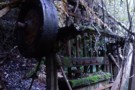
Battery at Cedar Creek Reefs June 2018
Photograph
•
Distance: 6.6km away
This photo was taken not far from the Mt Greenland Hut and illustrates just one of the many relics associated ...
More ▶︎
Mt Misery & beyond February 2013
Photograph
•
Distance: 6.6km away
Last month I decided to climb a hill that can be seen from home that I'd never got around to ...
More ▶︎
Toaroaha Saddle-Frew Saddle Circuit
Track
•
4 – 6 days. Medium. One way.
•
Distance: 7.2km away
A great tramp in a remote location, crosses two alpine saddles, ice-axes and crampons needed in winter. More information on ...
More ▶︎
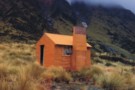
Mt Greenland Hut
Photograph
•
Distance: 7.2km away
This four bunk hut was built by a mineral prospecting outfit circa 1980. (Consolidated Traders, Mining Division) Around 2001 it ...
More ▶︎
Mt Greenland Hut
Hut
•
Standard Hut (DOC). Capacity: 4.
•
Distance: 7.2km away
A 4 bunker dating back to about 1980. A previous Mt Greenland Hut built 1903 in a different location closer ...
More ▶︎
Historic Price Flat Hut
Hut
•
Basic Hut/Bivvy (DOC). Capacity: 4.
•
Distance: 7.4km away
Slab hut once used for deer culling and possibly dating to 1908. The hut is located next to the newer ...
More ▶︎
Top Tuke hut Dec 1975
Photograph
•
Distance: 7.5km away
This four bunk hut is located on the TR in the head basin of the Tuke River a tributary of ...
More ▶︎
Top Tuke hut
Hut
•
Basic Hut/Bivvy (DOC). Capacity: 4.
•
Distance: 7.5km away
This four bunk hut is located on the TR in the head basin of the Tuke River a tributary of ...
More ▶︎
Top Tuke hut March 2012
Photograph
•
Distance: 7.5km away
Here is a photo of this hut from a different angle than the 1975 one I posted and "major's" one ...
More ▶︎
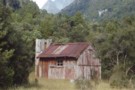
Prices Flat Hut (historic)
Photograph
•
Distance: 7.6km away
Prices Flat Hut (historic) - in the Whitcombe Valley, Westland. A place full of character, and full of sandflies. A ...
More ▶︎
Prices Flat Hut (historic)
Hut
•
Basic Hut/Bivvy (DOC). Capacity: 4.
•
Distance: 7.6km away
The historic Prices Flat Hut is better looked at than slept in. It is a beutiful slab hut, with an ...
More ▶︎
Dickie Spur hut & Tuke River headwaters Jan 2012
Photograph
•
Distance: 7.6km away
Here is another photo of Dickie Spur hut to go with the one from 1975 that I posted on here. ...
More ▶︎
Dickie Spur from Healey Spur May 2008
Photograph
•
Distance: 7.7km away
This photo looks SW across the Tuke River to Dickie Spur and the northern end of Dickie Ridge. If you ...
More ▶︎
Dickie Spur hut July 1975
Photograph
•
Distance: 7.7km away
This hut is in the scrub tussock transition zone on a spur running east toward the Tuke River off the ...
More ▶︎
Dickie Spur hut
Hut
•
Basic Hut/Bivvy (DOC). Capacity: 4.
•
Distance: 7.7km away
This hut is in the scrub tussock transition zone on a spur running east toward the Tuke River off the ...
More ▶︎
Price Flat Hut
Hut
•
Standard Hut (DOC). Capacity: 6.
•
Distance: 7.8km away
Prices Flat Hut (6 bunks, matresses, tank water, stove) lies on a small terrace 100m above the Whitcombe River, adjacent ...
More ▶︎
Prices Flat Hut
Photograph
•
Distance: 7.8km away
The new(er) Prices Flat Hut, in the Whitcombe Valley, Westland.
More ▶︎
Mt Greenland trig
Photograph
•
Distance: 8.1km away
I visited this trig beacon recently during cloudy weather. Whilst the views were no good from the hill top in ...
More ▶︎
View SE along the Meta Range March 2011
Photograph
•
Distance: 8.3km away
This picture was taken from near the summit of Mt Inframeta & looks along the Meta Range toward the Southern ...
More ▶︎
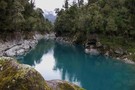
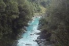
Hokitika River (Bottom Gorge)
Photograph
•
Distance: 8.5km away
This photo looks upstream from 5 minutes above the swingbridge at the Hokitika Gorge. (The furthest downstream & closest to ...
More ▶︎
Hokitika Gorge
Track
•
Easy. Return by the same track.
•
Distance: 8.6km away
A short walk near Hokitika, crossing the glacial-blue waters of the Hokitika River.
More ▶︎
View up Whitcombe from Meta Range Feb 2011
Photograph
•
Distance: 8.7km away
This pic looks out over Frews Ck and up the Whitcombe River to those famed spots of hunting folklore The ...
More ▶︎
Dickie Spur
Photograph
•
Distance: 9.0km away
A perfect day on the Dickie Spur above the Mikonui River, looking towards Okarito
More ▶︎
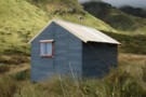
Price Basin hut
Hut
•
Basic Hut/Bivvy (DOC). Capacity: 4.
•
Distance: 9.0km away
This hut, which is usually known as Price(s) Basin, is located on the TL of the TR branch of the ...
More ▶︎
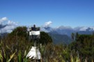
Constitution Hill trig
Photograph
•
Distance: 9.4km away
Last month I visited this historic trig beacon and cleared the scrub and small trees that were growing up through ...
More ▶︎