Nearby
Watchdog Hut
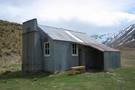
McCoy Hut
Hut
•
Standard Hut (DOC). Capacity: 6.
•
Distance: 3.4km away
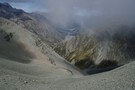
McCoy hut is a six bunk hut located on the confluence of Franceis River and McCoy Stream, which flows down ...
More ▶︎
packrafting trip from upper Rakia to Erewhon Station
Video
•
Distance: 6.6km away
Climbing over Butler Saddle and packrafting down Lawrrence and Clyde Rivers to Erwehon Station in December 2008
More ▶︎
Curtis Memorial Hut
Hut
•
Standard Hut (DOC). Capacity: 4.
•
Distance: 7.9km away
Hut on the Havelock River opposite the confluence of the Forbes.
More ▶︎
Lawrence Hut
Hut
•
Standard Hut (DOC). Capacity: 6.
•
Distance: 7.9km away
Lawrence Hut (6 bunks, matresses, stove, tank water) is a pleasent forestry-style hut on river terraces in the lower reaches ...
More ▶︎
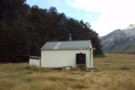
Lawrence Hut
Photograph
•
Distance: 7.9km away
Lawrence Hut, in the Lawrence River valley, Canterbury
More ▶︎

Route Guide: Otira to Mt Cook Village (pt 2)
Track
•
12 – 21 days. Hard. One way.
•
Distance: 7.9km away
One possible route down the main divide from Otira on the Arthur's Pass road to Mt Cook Village.
Otira Hotel ...
More ▶︎
Crossing the Clyde and Havelock - brushes with the Canterbury Death
Article
•
Distance: 7.9km away
High rivers ... lessons learnt.
Day 11 of the Otira to Mt Cook leg of my Southern Traverse
More ▶︎

Route Guide: Otira to Mt Cook Village (pt 1)
Track
•
12 – 21 days. Hard. One way.
•
Distance: 7.9km away
One possible route down the main divide from Otira on the Arthur's Pass road to Mt Cook Village.
Otira Hotel to ...
More ▶︎
Picton to Aspiring
GPX file
•
Distance: 8.0km away
An aborted alpine traverse. Picton to West Cape, but aborted at Aspiring due to real world emergencies back home. Posted ...
More ▶︎
Eric Bivvy
Hut
•
Basic Hut/Bivvy (Canterbury Mountaineering Club).
•
Distance: 8.6km away
A tidy historical shelter located on Agony Island near St Winifred Hut. Currently, the hut is great for shelter especially ...
More ▶︎
St Winifreds Hut
Hut
•
Standard Hut (Canterbury Mountaineering Club). Capacity: 9.
•
Distance: 8.6km away
Iron hut owned by the Canterbury Mountaineering Club. The hut was built in 1959 to replace the old Havelock Hut. ...
More ▶︎
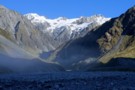
View from St Winifreds Hut
Photograph
•
Distance: 8.6km away
The mountains around the upper havelock river from the front of st winifred's hut.
More ▶︎
At Veil Stream
Photograph
•
Distance: 8.7km away
the havelock valley finally starts to narrow down
More ▶︎
Veil Biv
Hut
•
Basic Hut/Bivvy (NZDA). Capacity: 3.
•
Distance: 8.7km away
This biv is located at the confluence of Veil Stream with the Havelock River. It was moved to a new ...
More ▶︎
Mistake Flat Hut
Hut
•
Standard Hut (DOC). Capacity: 6.
•
Distance: 8.9km away
Hut on the Mistake Flats, where the Forbes meets the Havelock River.
More ▶︎
Te Kahui Kaupeka Conservation Park
Place
•
Conservation Park. 938.00km2.
•
Distance: 9.0km away
Canterbury high country park including the Two Thumb Range and large portions of Mesopotamia Station.
More ▶︎