Nearby
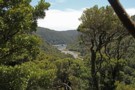
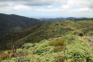
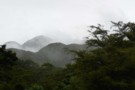
Interior of the Northern Tararua Range
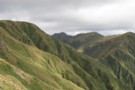
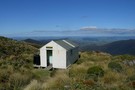
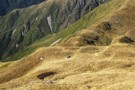
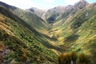
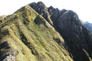
Saddle between East Peak and West Peak Northern Tararua
Photograph
•
Distance: less than 100m away
The Saddle between East Peak and West Peak, Dundas Ridge, Northern Tararua . With Walker and Pukemoremore beyond .
More ▶︎
A Total Tararua Traverse
Track
•
8 – 16 days. Medium. One way.
•
Distance: 856m away
The length of the Tararuas via the pointy bits, from the Manawatu Gorge at Woodville to the Rimutaka Hill Road ...
More ▶︎
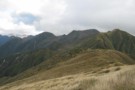
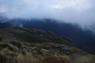
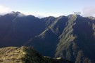
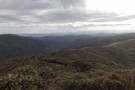
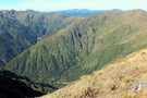
Dundas Ridge from West Peak
Photograph
•
Distance: 1.1km away
The view along the backbone of the Dundas ridge from West Peak, showing Walker, Dome and Pukemoremore
More ▶︎
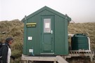
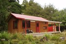
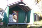
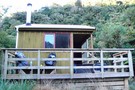
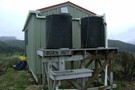
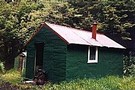
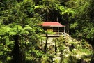
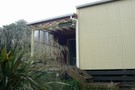
Herepai Hut
Hut
•
Standard Hut (DOC). Capacity: 10.
•
Distance: 2.2km away
An older huts lower than the bush line. It has a cast-iron fire, two platforms for sleeping quarter. It holds ...
More ▶︎
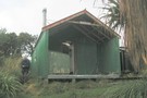
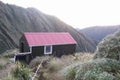
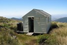
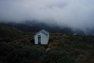
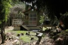
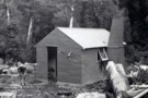
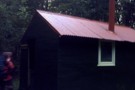
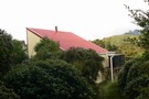
Herepai Hut
Photograph
•
Distance: 2.2km away
Herepai Hut from the ridge up to Herepai - February 2007
More ▶︎
Tararua main ridge
Track
•
4 – 8 days. Medium. One way.
•
Distance: 2.2km away
The length of the tracked Tararuas along the main ridge from Mangahao (behind Shannon) to Kaitoke.
For a 'Total Tararua Traverse ...
More ▶︎
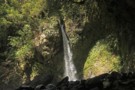
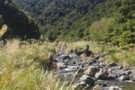
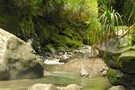
Ruapae Falls Tararua's
Photograph
•
Distance: 3.2km away
Ruapae Falls are in the headwaters of the Magatainoka River near Eketahuna. The falls can be reached by following the ...
More ▶︎
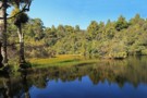
Hidden Lake Tararua Ranges -1
Photograph
•
Distance: 3.2km away
Hidden Lake is about 35 to 45 minutes upstream from Roaring Stag Lodge in the Tararua's. It is situated on ...
More ▶︎
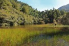
Hidden Lake Tararua Ranges
Photograph
•
Distance: 3.2km away
Hidden Lake is about 35 to 45 minutes upstream from Roaring Stag Lodge in the Tararua's. It is situated on ...
More ▶︎
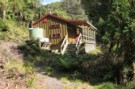
Dundas Hut
Hut
•
Standard Hut (DOC). Capacity: 6.
•
Distance: 3.6km away
Dundas Hut (4 bunk) sits in one of the best spots of any hut in the North Island. It perches ...
More ▶︎
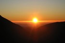
Sunrise from Dundas Hut
Photograph
•
Distance: 3.6km away
Sunrise from Dundas Hut - February 2007
More ▶︎
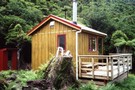
Cattle Ridge Hut
Photograph
•
Distance: 3.9km away
This is on the excellent Herepai-Dundas-Cattle Ridge-Roaring Stag Hut circuit in the Tararuas.
More ▶︎
Cattle Ridge Hut
Photograph
•
Distance: 3.9km away
Cattle Ridge Hut: the outside showing it's age, but still a pleasent tidy hut inside. A peaceful alternative to the ...
More ▶︎
Cattle Ridge Hut
Photograph
•
Distance: 3.9km away
Cattle Ridge Hut: nestled in a tussock and letherleaf basin at the north end of Cattle Ridge. This was a ...
More ▶︎
Cattle Ridge Hut
Hut
•
Standard Hut (DOC). Capacity: 5.
•
Distance: 3.9km away
A 5 bunk old style forest service hut located 2 to 3 Hrs up a steep spur from Roaring Stag ...
More ▶︎
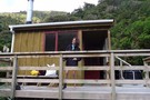
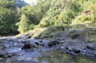
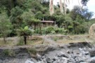
Roaring Stag Lodge
Photograph
•
Distance: 4.6km away
Roaring Stag Lodge, Ruamahanga River, Tararua Range
More ▶︎

Roaring Stag Lodge
Hut
•
Standard Hut (DOC). Capacity: 16.
•
Distance: 4.6km away
16 bunk fairly new hut located in a neat spot next to the Ruamahanga river.A combined effort by DOC and ...
More ▶︎
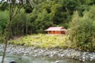
Roaring Stag Lodge
Photograph
•
Distance: 4.6km away
On the banks of the Ruamahanga River, Tararua Range. 2 to 3 hours from the road end and another couple ...
More ▶︎

Mangahao Vally Bush
Photograph
•
Distance: 4.8km away
About an hour South of Mangahao Hut, the bush is wet and damp, with mud up to your knees. Fantastic.
More ▶︎
Mangahao Flats Hut
Hut
•
Standard Hut (DOC). Capacity: 16.
•
Distance: 5.2km away
A huge modern hut put in between (now removed) Harris Creek Hut and (now removed) Avalanche Flats Hut. Approximately five ...
More ▶︎
Number 1 dam on the Mangahao River
Photograph
•
Distance: 6.5km away
Taken from the Puketurua Ridge. The ridge is accessed from Baber Forks where College Creek and Baber Creek join. The ...
More ▶︎
Waingawa Track
Track
•
Medium. One way.
•
Distance: 7.0km away
This is a non maintained route leading from Arete Forks up to the point of Waingawa 1420 Metres.The route meets ...
More ▶︎
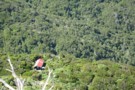
Dundas Hut, Tararuas
Photograph
•
Distance: 7.1km away
The hut is the orange dot, just off the spur. Photo taken from main ridge, looking south.
More ▶︎
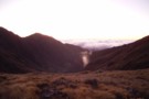
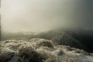
Park Valley Sunset
Photograph
•
Distance: 7.6km away
Looking West into a gathering storm, down the park Valley. It's sunset just over the ridge from the new Arete ...
More ▶︎
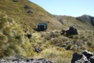
Arete biv
Photograph
•
Distance: 7.6km away
Arete Biv from the turnoff on the ridge north of Arete. The route to Tarn Ridge leads off to the ...
More ▶︎
Arete Biv
Photograph
•
Distance: 7.6km away
Arete Biv in the Northern Tararua's midway between Te Matawai and Tarn Ridge. 2 bunks
More ▶︎
Arete Hut
Hut
•
Basic Hut/Bivvy (DOC). Capacity: 2.
•
Distance: 7.8km away
DOC's website states that they upgraded the small, cold Arete Biv to a 2-bunk 'Arete Hut' in 2007.
Arete lies ...
More ▶︎
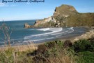
Castle Rock ,Castlepoint,Wairarapa
Photograph
•
Distance: 7.8km away
The bay is called Deliverence Cove , named by Captain James Cook during exploration of the New Zealand coast.Popular with ...
More ▶︎
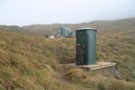
Arete Hut and Norski toilet
Photograph
•
Distance: 7.8km away
These toilets are becoming common in the backcountry. Single pit ,1 seat, plenty of light, fibre glass construction . Only ...
More ▶︎
North Ohau Hut November 2011
Photograph
•
Distance: 8.0km away
North Ohau is reached via the Ohau River and then the North Branch of the Ohau. All river travel except ...
More ▶︎
North Ohau
Photograph
•
Distance: 8.0km away
North Ohau Hut on the Ohau River, Tararua Range. Take the sidle track from Poads Road for about 1 hour ...
More ▶︎
North Ohau Hut
Hut
•
Standard Hut (DOC). Capacity: 4.
•
Distance: 8.0km away
North Ohau Hut is a cozy 4-bunk hut in the middle reaches of the North Ohau River in the Tararuas. ...
More ▶︎
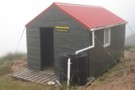
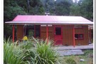
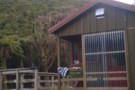
Herepai Hut
Photograph
•
Distance: 8.0km away
Nice 10 bunk hut, Steady climb up but well worth it with the tops only an hour walk away
More ▶︎
North Ohau Hut Exterior
Photograph
•
Distance: 8.3km away
The cosy little 4 bunk North Ohau hut in the Tararuas. A fairly easy walk in low river conditions and ...
More ▶︎
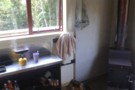
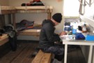
North Ohau Hut interior 1
Photograph
•
Distance: 8.3km away
Interior of the cosy little North Ohau hut in the Tararuas
More ▶︎
North Ohau Hut approach
Photograph
•
Distance: 8.3km away
5 mins from North Ohau Hut in the Tararuas
More ▶︎
Arete Sidle track
Track
•
Medium/hard. Return by the same track.
•
Distance: 8.5km away
Track between Cow Creek Hut and Arete Forks hut in the Upper Waingawa valley in Tararua Forest Park.
More ▶︎
Arête Forks Hut
Photograph
•
Distance: 8.5km away
Arete Forks Hut, taken not long after construction in 1960.
More ▶︎
Arete Forks Hut
Photograph
•
Distance: 8.6km away
Arete Forks Hut at the forks in the valley floor, on the eastern side of the Waiohine Pinnacles.
More ▶︎

Arete Forks Hut
Photograph
•
Distance: 8.6km away
Repainted Arete Forks hut in original Orange colour, Tararua Forest Park. Open Fireplace restored June 2016
This hut along with 4 ...
More ▶︎
Arete Forks Hut
Hut
•
Standard Hut (DOC). Capacity: 6.
•
Distance: 8.6km away
Arete Forks hut, photo taken in 1960 not long after construction. (6 bunks, wood-burner, firewood available) is a standard forestry ...
More ▶︎
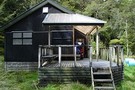
Burn Hut
Photograph
•
Distance: 8.7km away
Burn Hut in the Mangahao catchment, Northern Tararua Range. A good loop is from the number 2 dam downriver to ...
More ▶︎
Burn Hut
Photograph
•
Distance: 8.7km away
Burn Hut. 2 hours from Mangahoa Dam 2, near Shannon
More ▶︎
Burn Hut
Hut
•
Basic Hut/Bivvy (DOC). Capacity: 6.
•
Distance: 8.7km away
Cool wee hut sitting on the tops a few hours from Mangahoa Dam 2, near Shannon. Great view. Walk in ...
More ▶︎
Cow Creek Hut
Hut
•
Standard Hut (DOC). Capacity: 6.
•
Distance: 9.1km away
Nice hut with a camping site nearer the river. The cable-way giving access across the river is fun. 6 bunks ...
More ▶︎
Upper Park River
Photograph
•
Distance: 9.3km away
Taken from the Tararua Main Range looking into the headwaters of the Park River. Waiohine Pinnacles on the right and ...
More ▶︎
Waiohine Pinnacle
Photograph
•
Distance: 9.4km away
The route up the Waiohine Pinnacle spur from Arete Forks taken from Bannister ridge.
The Arete Stream in the foreground, avoid ...
More ▶︎
South Ohau Hut
Hut
•
Standard Hut (DOC). Capacity: 10.
•
Distance: 9.5km away
A new hut opened in October 2008 replaces an older hut that now forms the base for the woodshed. The ...
More ▶︎
South Ohau Hut
Photograph
•
Distance: 9.5km away
South Ohau Hut Tararua Range. One of the new standard 10 bunk huts. On a river terrace at the confluence ...
More ▶︎
South Ohau Hut
Photograph
•
Distance: 9.5km away
South Ohau Hut Tararua Range. One of the new standard 10 bunk huts. On a river terrace at the confluence ...
More ▶︎
South Ohau Hut
Photograph
•
Distance: 9.5km away
South Ohau Hut Tararua Range. One of the new standard 10 bunk huts. On a river terrace at the confluence ...
More ▶︎
Waiohine Pinnacle track
Track
•
Medium/hard. Return by the same track.
•
Distance: 9.5km away
Gives access from Arete Forks to Waiohine Pinnacles on Tarn Ridge
Ascends Pinnacle Spur from the Arete Stream Junction
More ▶︎
Waiohine Pinnacles
Photograph
•
Distance: 9.5km away
Waiohine Pinnacles, Tararua Range. Between Arete and Tarn Ridge. The route across the pinacles is OK, a little steep and ...
More ▶︎
Te Matawai
Hut
•
Standard Hut (DOC). Capacity: 18.
•
Distance: 9.6km away
A big L-shaped hut with 2 big sleeping platforms (18 mattresses) in one arm and the living area in the ...
More ▶︎
Route Guide: Northern Crossing of the Tararuas
Article
•
Distance: 9.6km away
This is not the usual Northern Crossing from Levin to The Pines via Mitre Flats Hut. Rather it exits via ...
More ▶︎
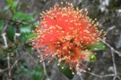
Rata Flower
Photograph
•
Distance: 9.6km away
Rata Flower in the Ohau River, Tararua Range. Probably R. Fulgens
More ▶︎