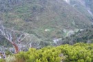
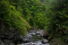
Nearby
Pohangina scramble
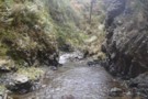
Upper Pohangina
Photograph
•
Distance: less than 100m away
River route to Mid Pohangina Hut from Cattle creek
More ▶︎
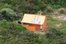
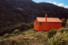
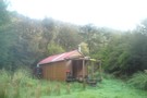
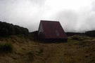
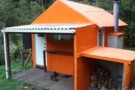
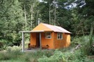
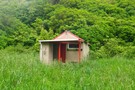
Cattle Creek Hut
Photograph
•
Distance: 298m away
A tidy 8 bunk platform style hut fully resplendent in its updated NZFS orange colour scheme.
More ▶︎
Cattle Creek Hut
Hut
•
Standard Hut (DOC). Capacity: 6.
•
Distance: 774m away
On river flats in the upper reaches of Cattle Creek lies Cattle Creek Hut (6 beds, wood-burning stove, firewood available ...
More ▶︎
Walking the length of the Ruahines
Article
•
Distance: 774m away
This article documents my recollections of the Ruahine setion (Wharite to Kuripapango) of a walk from Wharite near Palmerston North ...
More ▶︎
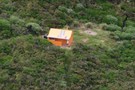
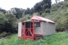
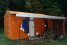
Cattle Creek Hut
Photograph
•
Distance: 774m away
A tidy 8 bunk platform style hut resplendent in forest service orange.
More ▶︎
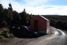
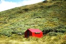
Cattle Creek Hut
Photograph
•
Distance: 917m away
Cattle Creek hut in the southern Ruahine Range
More ▶︎
Southern Crossing of the Ruahines
Track
•
2 – 3 days. Easy/medium. One way.
•
Distance: 917m away
A track and river route crossing of the Lower Ruahine Forest park
More ▶︎
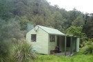
Mid Pohangina Hut
Hut
•
Standard Hut (DOC). Capacity: 4.
•
Distance: 1.8km away
Mid Pohangina Hut sits on a pleasant grassy flat just above the Pohangina River north of its confluence with Cattle ...
More ▶︎
Mid Pohangina Hut 15 minutes
Photograph
•
Distance: 1.9km away
After wandering down the river you arrive cold and wet (on an off day) at this sign which points at ...
More ▶︎
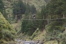
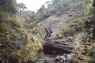
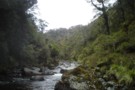
Pohangina crossing
Photograph
•
Distance: 2.1km away
Swing bridge below Mid Pohangina hut and the start of the ubiquitous sidle track. Why does the term sidle always ...
More ▶︎
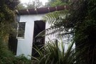
Duck Pond Hut
Photograph
•
Distance: 2.6km away
A private 2-bunk hut, tucked into the headwaters of the Ngamoko catchment in the Ruahines.
More ▶︎
Duck Pond Hut
Hut
•
Private hut (PVT). Capacity: 2.
•
Distance: 2.6km away
A 2-bunk hut on private land, just outside the Ruahine forest park. This hut lies in the upper reaches of ...
More ▶︎
Ngamoko Hut
Photograph
•
Distance: 2.6km away
A pleasant 6-bunk hut looking across the mid reaches of the Pohongina to a large grassy slip. An hour or ...
More ▶︎
Ngamoko Hut
Hut
•
Standard Hut (DOC). Capacity: 6.
•
Distance: 2.6km away
Ngamoko Hut (6 bunks, stove, river water) is a pleasent hut located in scrub on the western bank of the ...
More ▶︎
Standfield Hut
Hut
•
Standard Hut (DOC). Capacity: 6.
•
Distance: 3.3km away
Standfield (Stanfield) Hut (6 bunks, woodburing stove, tank water, firewood available in locality) is a comfortable riverside hut on the ...
More ▶︎
Piripiri Hut
Hut
•
Basic Hut/Bivvy (DOC). Capacity: 2.
•
Distance: 4.1km away
Piripiri Hut is a comfortably spacious 2-bunk hut in the western Ruahine Ranges. Water is from a small creek 20m ...
More ▶︎
Walking the length of the Ruahines
Track
•
10 – 25 days. Medium/hard. One way.
•
Distance: 4.1km away
A 10+ day trip down to backbone of the Ruahine Range from Wharite (Palmerston Sth) to the Napier Taihape (Gentle ...
More ▶︎
Forks Hut, Diggers Hut and Te Ekaou Hut access
Track
•
1 – 2 days. Medium. One way.
•
Distance: 5.1km away
Several public and private access routes into these huts in the southern Ruahines and suggested round and though trips.
More ▶︎
Pohongina River at Leon Kinvig hut
Photograph
•
Distance: 6.3km away
Grassy faces and scattered beech predominate on the Pohongina valleysides above Leon Kinvig
More ▶︎
Leon Kinvig Hut
Hut
•
Standard Hut (DOC). Capacity: 8.
•
Distance: 6.3km away
Leon Kinvig Hut sleeps 8 on 2 platforms. There's a good open fire, plenty of wood around, and water from ...
More ▶︎
Leon Kinvig Hut
Photograph
•
Distance: 6.3km away
A tidy 8-bunk hut in the mid-reaches of the Pohongina Valley. Tracks climb both ranges to the east and west, ...
More ▶︎
Leon Kinvig Hut
Photograph
•
Distance: 6.3km away
Leon Kinvig Hut is in the middle reaches of the Pohangina River in the Ruahines and can be reached from ...
More ▶︎
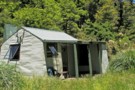
Takapari A Frame Hut / Travers Hut / Traverse Hut (Ruahine)
Hut
•
Basic Hut/Bivvy (DOC). Capacity: 6.
•
Distance: 6.5km away
Travers (6 bunks, no matresses) is a very basic A-frame hut on the Takapari Road in the Southern Ruahines. There's ...
More ▶︎
A-Frame hut (Traverse hut)
Photograph
•
Distance: 6.9km away
Very basic htu, was a very welcome sight to see takapari road after a pretty much 2 and a half ...
More ▶︎
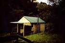
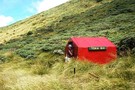
Looking down onto Cattle Creek Hut from ridge
Photograph
•
Distance: 6.9km away
Looking down onto the hut from the ridge just above it, quite a steep drop strait down to hut, easier ...
More ▶︎
A-Frame track looking down onto holmes ridge
Photograph
•
Distance: 6.9km away
Steady climb for about 2 and a half hours, views definitly paid off, weather isnt to good to be on ...
More ▶︎
Stanfield Hut
Photograph
•
Distance: 6.9km away
nice 2 and a half hour walk via holmes ridge, Perfect for a little day trip or for a 1st ...
More ▶︎
Track from Takapari Rd down to Diggers Hut
Photograph
•
Distance: 7.8km away
Track from Takapari Rd down to Diggers Hut, southern Ruahines. About 5km down this broad but sometimes boggy track, then ...
More ▶︎
Longview Makaretu Awatere Circuit
Track
•
2 days. Easy/medium. Loop track.
•
Distance: 8.0km away
2 Day circuit in the Ruahine Forrest park from Moorcock Saddle 3 huts some tops bush and river travel.
More ▶︎
Makaretu Hut
Photograph
•
Distance: 8.0km away
8 bunk hut on the southern branch of the Makaretu river
More ▶︎
Makaretu
Hut
•
Standard Hut (DOC). Capacity: 8.
•
Distance: 8.0km away
8 Bunk hut Southern branch Makaretuu river. Visit as part of a circuit from moorcock saddle including Longview and Awatere ...
More ▶︎
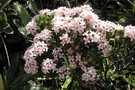
Pimelea near Toka
Photograph
•
Distance: 8.0km away
Pimelea in flower near Toka Trig, Ngamoko Range in the western Ruahines (Poss P. Buxifolia)
More ▶︎
Toka Biv
Hut
•
Basic Hut/Bivvy (DOC). Capacity: 2.
•
Distance: 8.5km away
Toka Biv (2 bunk, tarn water) is a small dog-box bivvy on a small plateau on the Pohongina Valley side ...
More ▶︎
Toka Biv
Photograph
•
Distance: 8.5km away
Toka Biv in the Ruahine Range Between Toka and Tunopo. Used to be called Ngamoko Biv. It sits on a ...
More ▶︎
Toka Biv
Photograph
•
Distance: 8.5km away
Toka Biv in the Ruahine Range Between Toka and Tunopo. Used to be called Ngamoko Biv. It sits on a ...
More ▶︎
Diggers Hut
Photograph
•
Distance: 9.8km away
Diggers Hut in the Ruahines. A spacious 4-bunk hut at the back of a flat of waist-high grass in the ...
More ▶︎
Diggers Hut
Hut
•
Standard Hut (DOC). Capacity: 4.
•
Distance: 9.9km away
Diggers Hut has been washed away.
Diggers Hut in the Ruahines. A spacious 4-bunk hut at the back of a flat ...
More ▶︎
Makawakawa Stream below Diggers Hut
Photograph
•
Distance: 9.9km away
Makawakawa Stream below Diggers Hut in the Ruahines. The riverbed route into the hut from Pohongina Valley East Rd.
More ▶︎
Happy Daze Hut
Hut
•
Basic Hut/Bivvy (DOC). Capacity: 4.
•
Distance: 9.9km away
Small, with ample camping. Seems to be some dispute over naming, with Happi Daze being (somewhat forcefully) pushed by some.
More ▶︎