Nearby
Kotepato Hut
A Waioeka - Urewera crossing: Redpaths Road to SH38
Track
•
4 – 7 days. Medium. One way.
•
Distance: 1.7km away
Continuing my traverse of the North Island's Main Range, this trip crosses the Waioeka Conservation and (former) Urewera National Park, ...
More ▶︎
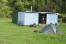
Nikau Flat Hut
Hut
•
Standard Hut (DOC). Capacity: 6.
•
Distance: 4.0km away
Nikau Flat hut: a 6 bunk forestry-style hut in a grassy clearing beside the Wioweka River.
This is a comfortable hut ...
More ▶︎
Urutawa Crossing: Motu Road to Waioeka Gorge
Track
•
2 – 4 days. Medium. One way.
•
Distance: 5.8km away
A north-east - south-west crossing of the Urutawa conservation area from Toatoa on the Motu Road to SH2 in the ...
More ▶︎
A Waioeka - Urewera Tarverse
GPX file
•
Distance: 6.8km away
A trip shadowing the main divide through the Waioeka Conservation Area and Urewera National Park.
See related track for a route ...
More ▶︎
Urutawa Crossing - Motu Rd to Waioeka Gorge
GPX file
•
Distance: 6.9km away
Urutawa Crossing - Motu Rd to Wioeka Gorge
Via: Pakihi hut, Te Waiti Hut, Midway Hut, Tokenui Hut.
Mainly on rough tracks ...
More ▶︎
Urutawa Conservation Area
Place
•
Place.
•
Distance: 6.9km away
Located 14km south of Opotiki off SH2. To the east of Waioeka gorge.
More ▶︎
Waioeka Conservation Area
Place
•
Place.
•
Distance: 7.7km away
Waioeka CA lies south of Opotiki, west of Waioeka gorge, and adjoining Te Uewera National Park.
More ▶︎
View from Koranga Forks Hut
Photograph
•
Distance: 7.9km away
Taken from the edge of the water looking backup at the bridge across the Koranga stream.
More ▶︎
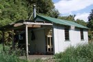
Koranga Forks Hut
Hut
•
Standard Hut (DOC). Capacity: 6.
•
Distance: 7.9km away
Koranga Forks Hut
More ▶︎
Five Day Trip in the Ureweras
GPX file
•
Distance: 10.0km away
A GPX file of a 5 day loop walk in the Ureweras
More ▶︎
A 5 day loop in the Ureweras
Track
•
5 – 7 days. Medium. Loop track.
•
Distance: 10.0km away
Wet rocky streams, long hauls over bush ridges on overgrown tracks, not much in the way of open tops. It ...
More ▶︎