Nearby
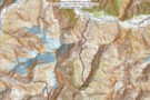
Aspiring - Rees
Rees - Dart
GPX file
•
Distance: less than 100m away
Starting at Muddy Creek, this track heads up the Rees River to the head of the valley with a short ...
More ▶︎
Matukituki to Paradise by roads less travelled
GPX file
•
Distance: less than 100m away
A rough, tough crossing from Raspberry Flat (Aspiring Road, Wanaka) to the Earnslaw Burn (Glenorchy-Paradise road) via Shotover Saddle, Lochnagar, ...
More ▶︎

Haast to The Divide
GPX file
•
Distance: less than 100m away
Andrew Barker's traverse 2009. From Pleasant Flat in the Haast to The Divide via Mt Aspiring National Park.
More ▶︎
French Ridge
Track
•
2 – 4 days. Medium. Return via same track.
•
Distance: less than 100m away
A steep climb to the snowline in the West Matukituki.
More ▶︎
Rees-Dart Track
Track
•
3 – 4 days. Medium/hard. Loop track.
•
Distance: less than 100m away
Alpine circuit along two river valleys at the head of Lake Wakatipu.
More ▶︎
rees valley
Track
•
3 days. Medium. Return via same track.
•
Distance: 551m away
pleasant walk up the rees valley. the track gets a bit swampy at the start and then a few avalance ...
More ▶︎
25 Mile Hut
Hut
•
Removed!
•
Distance: 1.9km away
*EDIT* From DOCs website:
28 April 2016: Rees Valley - 25 Mile Hut removed
The derelict 25 Mile Hut in the Rees ...
More ▶︎
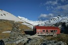
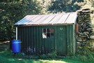
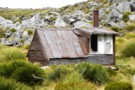
25-Mile Hut
Photograph
•
Distance: 1.9km away
This is a derelict Hut on the Rees Dart track. It is in an ideal location on a terrace above ...
More ▶︎
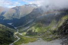
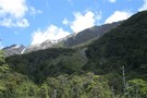
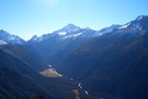
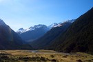
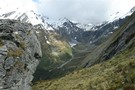
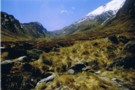
West Matukituki valley
Photograph
•
Distance: 3.1km away
Looking up the West Matukituki valley
More ▶︎
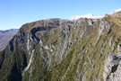
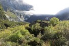
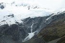
Mt Earnslaw from Earnslaw Burn
Photograph
•
Distance: 3.2km away
The cirque at the head of the Earnslaw Burn, taken from the descent from Lennox Pass
More ▶︎
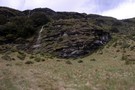
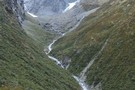
Lennox Creek, South Branch
Photograph
•
Distance: 3.6km away
Upper crossing of Lennox Creek (south branch). Not a place to be with unstable snow above.
The next viable crossing is ...
More ▶︎
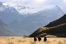
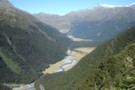
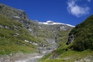
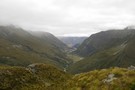
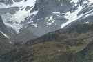
Rees valley
Photograph
•
Distance: 3.8km away
Looking up the Rees valley from near 25-mile spur (April 2009)
More ▶︎
Route from Pine Creek to Matukituki Valley via Shotover Saddle
GPX file
•
Distance: 4.0km away
(Partial) route from Pine Creek to Matukituki via Shotover Saddle. The cattle track passage in this file is probably very ...
More ▶︎
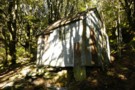
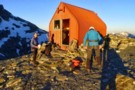
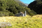
Earnslaw Hut - Mt.Earnslaw - Mt.Aspiring NP
Photograph
•
Distance: 4.1km away
At appx 980m set in beech forest above the Rees valley. This historic hut is on a short 50m side ...
More ▶︎
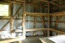
Looking inside Earnslaw Hut - Mt.Aspiring NP
Photograph
•
Distance: 4.1km away
An old hut with a distinctive rustic look. I believe many people would prefer to occupy the rock bivvy at ...
More ▶︎
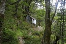
Earnslaw Hut
Photograph
•
Distance: 4.1km away
Rough four-bunk historic hut below Kea Basin on the ascent to Mt Earnslaw
More ▶︎
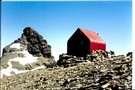
Earnslaw Hut
Hut
•
Basic Hut/Bivvy (DOC). Capacity: 4.
•
Distance: 4.1km away
Earnslaw hut. Located near Kea Basin on the slopes of Mt Earnslaw, above the Rees valley.
More ▶︎
Kea Basin Bivvy - Mt.Earnslaw
Photograph
•
Distance: 4.2km away
This is one of the best bivvy rocks i've seen. Situated at appx 1060m on the north flank of Mt.Earnslaw. ...
More ▶︎
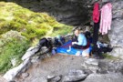
Earnslaw Burn Rock Bivvy, underneath.
Photograph
•
Distance: 4.8km away
Underneath the Rock Bivvy. This one is about 20 minutes upstream from the official one on the top map and ...
More ▶︎
Earnslaw Burn Rock Bivvy
Rock bivouac
•
Distance: 4.8km away
This is an alternative bivvy to the one shown on topo maps. This bivvy is about 20 minutes upstream from ...
More ▶︎
Earnslaw Burn Rock Bivvy
Photograph
•
Distance: 4.8km away
Alternative rock bivvy from the biv shown on the topo map. This bivvy is on the true left of the ...
More ▶︎
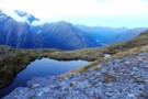
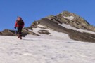
Shotover saddle tarn over the West Matukituki
Photograph
•
Distance: 4.9km away
With the Rob Roy glacier directly across the valley we're looking down valley toward Cameron corner where the East and ...
More ▶︎
Shotover stopover
Photograph
•
Distance: 4.9km away
Stopping short of descending to the West Matukituki and camping with sandflies on the valley floor we spent the last ...
More ▶︎
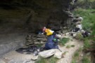
Shotover Saddle
Photograph
•
Distance: 4.9km away
When we crossed a bridge near to the mouth of the Shotover river just near Queenstown i reminded Kathryn we ...
More ▶︎
Lochnagar/Shotover Saddle/Matukituki Valley
Track
•
2 days. Medium/hard. One way.
•
Distance: 5.2km away
An alpine crossing of a saddle between 2 major river valleys. Usually done as part of a circuit of saddle ...
More ▶︎
route from Snowy Creek to Lochnagar via Shotover Saddle
Photograph
•
Distance: 5.2km away
Hand drawn route of above
More ▶︎
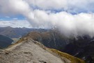
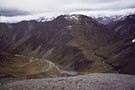
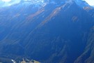
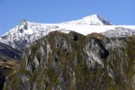
Looking south from Sysiphus Peak
Photograph
•
Distance: 6.0km away
The Matukituki East Branch winds its way down to meet the West Branch, where we started this walk yesterday. It's ...
More ▶︎
Aspiring Flat and Sisyphus Peak
Track
•
3 days. Medium. Return via same track.
•
Distance: 6.0km away
A one and two-half day tramp up the East Matukituki to overnight in Aspiring Flats, with a day trip up ...
More ▶︎
Picton to Aspiring
GPX file
•
Distance: 6.1km away
An aborted alpine traverse. Picton to West Cape, but aborted at Aspiring due to real world emergencies back home. Posted ...
More ▶︎

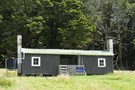
Cascade hut
Photograph
•
Distance: 6.3km away
Cascade hut in the West Matukituki valley, about 10km from the carpart, only about 1.5km short of Aspiring hut.
More ▶︎
Cascade hut
Photograph
•
Distance: 6.3km away
Cascade hut in the West Matukituki valley, about 10km from the carpart, only about 1.5km short of Aspiring hut.
More ▶︎
Cascade hut
Photograph
•
Distance: 6.3km away
Cascade hut in the West Matukituki valley, about 10km from the carpart, only about 1.5km short of Aspiring hut.
More ▶︎
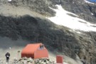
Esquilant Biv
Photograph
•
Distance: 6.5km away
A small 6-bunk hut on the shoulder of Mt Earnslaw. Could comfortably sleep 8, although there is not much room ...
More ▶︎
Esquilant Biv
Photograph
•
Distance: 6.5km away
Gearing up in the early morning to climb Mt Earnslaw. Esquilant is a 6 bunk hut situated at 2,160m.
More ▶︎
Mt Earnslaw
Article
•
Distance: 7.1km away
This was a sweet day trip taken in Feb 2008, bluebird day.
More ▶︎
Esquilant Bivvy Hut
Hut
•
Serviced Alpine Hut (NZAC). Capacity: 6.
•
Distance: 7.1km away
Small hut located on Wright's Col in the Rees Valley.
More ▶︎
Aspiring Hut
Photograph
•
Distance: 7.5km away
This 1949 hut is constructed from local schist.
More ▶︎
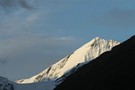
Mount Aspiring
Photograph
•
Distance: 7.5km away
Peering over the shoulder of Rob Roy Peak, late afternoon, Aspiring Hut.
More ▶︎
Cascade Saddle Route from Aspiring Hut
Photograph
•
Distance: 7.5km away
The route does not actually cross the saddle, but follows the rugged spur in the top centre of this photograph, ...
More ▶︎
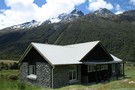
Aspiring Hut
Hut
•
Serviced Alpine Hut (NZAC). Capacity: 38.
•
Distance: 7.5km away
This historic hut in the West Matukituki Valley was constructed of local schist, and opened at Easter 1949. Situated immediately ...
More ▶︎

Snowy Creek
Photograph
•
Distance: 7.8km away
Snowy Creek - viewed from saddle 1950 on the way over from Lochnagar Hut
More ▶︎

Snowy Creek
Photograph
•
Distance: 7.8km away
Snowy Creek - viewed from saddle 1950 on the way over from Lochnagar Hut
More ▶︎
Upper Shotover
Photograph
•
Distance: 7.9km away
Shotover valley from the spur between Tummel Burn and Tyndall Creek.
More ▶︎
Glengyle Peak
Photograph
•
Distance: 8.2km away
Taken from below the Pylon on the Cascade Saddle route looking across the West matukituki towards Glengyle. If you look ...
More ▶︎
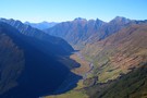
Lower Matukituki
Photograph
•
Distance: 8.2km away
Taken from the Cascade Saddle route a short distance below the Pylon looking downvalley towards the carpark at Raspberry Flat. ...
More ▶︎
West Matukituki valley
Photograph
•
Distance: 8.2km away
Taken from the Cascade Saddle route not far below the Pylon, looking up valley towards Mt Aspiring which towers above ...
More ▶︎
Mt Tyndall
Photograph
•
Distance: 8.4km away
from Cascade Saddle, looking south-east across Heads Leap to Mt Tyndall (2496m) (April 2009)
More ▶︎
Approaching Mt Tyndall
Photograph
•
Distance: 8.4km away
Mt Tyndall (2,496m) sits above the Isobel Glacier south of Cascade Saddle.
More ▶︎
Tummel Burn Hut
Hut
•
Basic Hut/Bivvy (PVT). Capacity: 3.
•
Distance: 8.6km away
Low 3 person unbunked private hut with open fire. 3 mattresses present (2009). Water supply from Tummel Burn 20m distant. ...
More ▶︎
Shovel Flat in the West Matukituki
Photograph
•
Distance: 8.6km away
A beutiful spot with heaps of great camping sites, French Ridge is the major ridge descending to the valley floor ...
More ▶︎
from Cascade Saddle
Photograph
•
Distance: 9.0km away
looking to the SE from Cascade Saddle, across Heads Leap to Cascade Falls
More ▶︎
Cascade Saddle Camp
Photograph
•
Distance: 9.0km away
Nice campsite where the Cascade Saddle track crosses the top of Cascade Creek, with Mt Aspiring visible over the ridge. ...
More ▶︎
French Ridge Track
Photograph
•
Distance: 9.5km away
The French Ridge Track features tangled roots, steep gradients, and clambering down rock walls.
More ▶︎
Pearl Flat to Scott's Bivvy
GPX file
•
Distance: 9.6km away
A new track has been cut through bush up the true left of the Matukituki river from Pearl Flat to ...
More ▶︎
Head of the Matukituki Valley West Branch
Photograph
•
Distance: 9.6km away
Viewed from French Ridge Track.
More ▶︎
Liverpool Hut
Photograph
•
Distance: 9.6km away
Viewed from the French Ridge Track across the valley
More ▶︎
Gloomy Gorge
Photograph
•
Distance: 9.7km away
Viewed from the French Ridge Track, with Mount Avalanche in the background.
More ▶︎
Mount Avalanche avalanche
Photograph
•
Distance: 9.7km away
Viewed from the French Ridge Track. Avalanches from here, from Rob Roy Peak, or from peaks across the valley can ...
More ▶︎
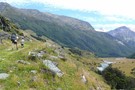
Rees Vally
Photograph
•
Distance: 9.7km away
This is a picture taken on the rees/dart track and is on day 2 of our tramp in between shelter ...
More ▶︎

Cascade Saddle
Photograph
•
Distance: 9.7km away
Looking down at the Saddle from above Heads Leap. A 500 metre cliff drops off to the Cascade creek floor ...
More ▶︎
French Ridge Hut
Photograph
•
Distance: 9.8km away
This NZAC hut is located on the summer snowline near Mount Aspiring.
More ▶︎
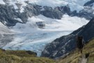
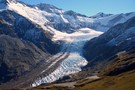
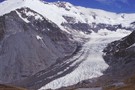
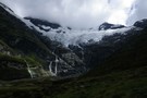
Dart Glacier
Photograph
•
Distance: 9.9km away
Located right beside the Cascade Saddle, a climb to the saddle allows you a view of the intier length of ...
More ▶︎