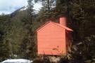
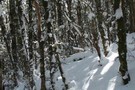
Nearby
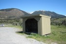
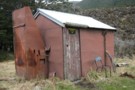
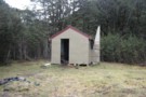
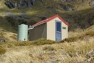
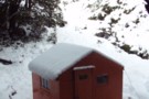
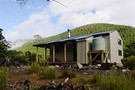
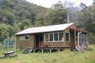
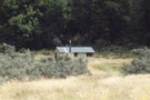
Doubtful Hut
Doubtfull Hut
Photograph
•
Distance: less than 100m away
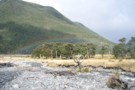
Doubtfull Hut showing damage to chimney
More ▶︎
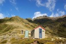
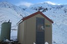
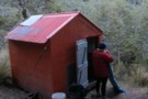
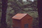
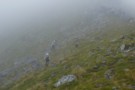
Doubtful Hut
Photograph
•
Distance: less than 100m away
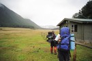
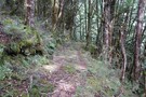
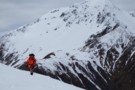
A good spot for a snack on the way up to Lake Man!
More ▶︎
Lake Sumner Conservation Park
Place
•
Conservation Park. 1057.71km2.
•
Distance: 2.7km away
Lakes and forested hills in this sprawling park provide good tramping, and contrast with the rugged alpine environment of Arthur's ...
More ▶︎
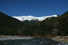
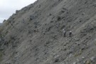
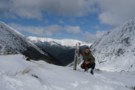
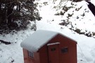
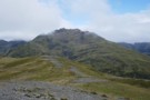
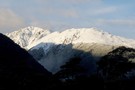
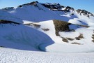
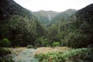
Climbing above Devilskin Saddle
Photograph
•
Distance: 4.8km away
day triping up from the Devilskin Saddle Hut June 2010. (lewis pass)
See hut and toilet on the saddle below.
Also see ...
More ▶︎
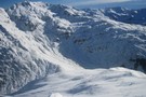
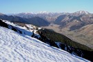
Scree traverse
Photograph
•
Distance: 4.9km away
a long traverse on virgin scree high above Devilskin saddle - Feb 2018
More ▶︎
Doubtless Hut
Hut
•
Standard Hut (DOC). Capacity: 6.
•
Distance: 4.9km away
Doubtless Hut. In the Doubtful River valley, further up from Doubtful hut.
More ▶︎
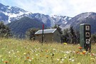
Devilskin Saddle
Photograph
•
Distance: 4.9km away
Devilskin Saddle between the Nina and Doubtful Valleys off the Lewis Pass. March 2007.
More ▶︎
New Devils Den Bivvy Location
GPX file
•
Distance: 4.9km away
A GPX file of the new bivvy located on Devilskin Saddle.
The old Devils Den Bivvy has been removed.
More ▶︎
Devilskin Saddle
Photograph
•
Distance: 4.9km away
from the saddle, the new biv is 50m west towards the Devils Rampart. (photo taken Feb 2018)
More ▶︎
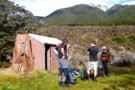
Devils Den Bivouac above Devilskin Pass
Photograph
•
Distance: 5.0km away
Built in 2008, this is, perhaps, the bestest and newest little hut in NZ.
More ▶︎
Devils Den Bivouac
Photograph
•
Distance: 5.0km away
Built in 2007 to replace the old version which was below Devilskin Saddle by the bushline. This new, sparkly version ...
More ▶︎
Lake Man biv
Photograph
•
Distance: 5.3km away
located in the trees about 1 hr from the lake.
More ▶︎
Picton to Aspiring
GPX file
•
Distance: 5.3km away
An aborted alpine traverse. Picton to West Cape, but aborted at Aspiring due to real world emergencies back home. Posted ...
More ▶︎
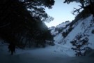
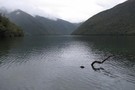
Snow, old Devil's Den Hut site
Photograph
•
Distance: 5.4km away
The old hut site was at the treeline east of Devilskin Saddle. After an avalanche, a new hut was built ...
More ▶︎
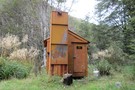
Devils Den Bivouac
Hut
•
Basic Hut/Bivvy (DOC). Capacity: 2.
•
Distance: 5.4km away
Devils Den / Devilskin bivouac (2 beds) is a brand new bivouac ABOVE Devilskin Pass. Built in 2008, this new ...
More ▶︎
Devils Den Bivouac
Photograph
•
Distance: 5.4km away
Devils Den Bivouac, below Devilskin Saddle between the Nina and Doubtful valleys. March 2007 - 3 feet of snow on ...
More ▶︎
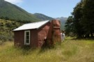
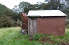
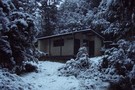
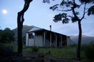
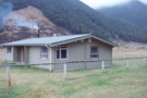
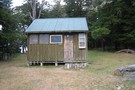
Doubtful Hut
Photograph
•
Distance: 5.4km away
Old timer shack with 3-4 bunks near the Doubtful River, Northern Canterbury.
More ▶︎
Lake Man Bivouac
Hut
•
Basic Hut/Bivvy (DOC). Capacity: 2.
•
Distance: 5.5km away
Lake Man Bivouac (2 bunk, no fire, stream water) is a basic bivouac 50m below the bushline near the head ...
More ▶︎
Near Devilskin Saddle
Photograph
•
Distance: 5.7km away
Fresh snow in the beech forest northeast of Devilskin Saddle. October 2009.
More ▶︎
Sylvia tops
Photograph
•
Distance: 6.0km away
on the Sylvia tops and in the clag as we contoured around the north side of SH1662 - Feb 2018
More ▶︎
Upper Nina Biv
Hut
•
Basic Hut/Bivvy (DOC). Capacity: 2.
•
Distance: 7.0km away
Small hut on the Nina River. Two canvas bunks.
More ▶︎
Lewis Pass National Reserve
Place
•
Reserve. 182.95km2.
•
Distance: 7.3km away
A small park occupying the forested valleys around Lewis Pass and bordering Lake Sumner and Victoria Forest Parks as well ...
More ▶︎
Devils Rampart
Photograph
•
Distance: 7.7km away
from the Sylvia tops, the Devils Rampart is slowly revealed as the mists begin to lift - Feb 2018
More ▶︎
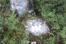
canada goose eggs
Photograph
•
Distance: 7.8km away
Canada goose eggs. Pussy stream, just inside the trees. She left in a hurry when I stumbled across her. Photo ...
More ▶︎
Nina Hut
Hut
•
Standard Hut (DOC). Capacity: 10.
•
Distance: 7.9km away
Replacing the old hut down by the river, this hut is located in an elevated clearing with good mountain views. ...
More ▶︎
Nina River
Track
•
2 days. Easy. Return by the same track.
•
Distance: 7.9km away
Easy tramping up a pretty river valley near Lewis Pass.
More ▶︎
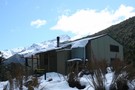
Nina Hut at Night
Photograph
•
Distance: 8.2km away
This hut is situated in a superb location, with wide views up all the valleys around it. A good move, ...
More ▶︎
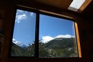
Nina Hut Views
Photograph
•
Distance: 8.2km away
Windows in the new Nina Hut are well set up for admiring the views.
More ▶︎
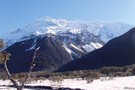
Lewis Tops from from Nina Hut
Photograph
•
Distance: 8.2km away
The view north from Nina Hut, March 2007
More ▶︎

St James Walkway
Track
•
5 days. Easy/medium. One way.
•
Distance: 8.3km away
A long and easy walk on St James Station near Lewis Pass. Beech forest, mountain scenery, farmland, wild horses, mud.
More ▶︎
St James Walkway June 2009
Photograph
•
Distance: 8.3km away
Gloriana and the Faerie Queene, on a brilliant winter's day.
More ▶︎
Boyle Flats Hut
Photograph
•
Distance: 8.3km away
Perched high on a river terrace, accessed from a swingbridge 'on the Boyle'.
More ▶︎
Ada Cullers Hut
Photograph
•
Distance: 8.3km away
Tidy old shack provides shelter and shade from the elements. No mattresses or water supply.
More ▶︎
Boyle Village - Mt Faust - Boyle Hut
Track
•
1 day. Medium. One way.
•
Distance: 8.3km away
A great trip over the top of Mt Faust and down a spur to Boyle Hut on the St James ...
More ▶︎

Te Araroa Trail
Track
•
95 days. Medium. One way.
•
Distance: 8.3km away
Te Araroa is a walking trail running the entire length of the North and South Islands. The trail opened 3 ...
More ▶︎
Magdalen Valley
Photograph
•
Distance: 8.3km away
View east over Magdalen Valley to Waiau from Faust
More ▶︎
Hope River / Pussy Stream confluence
Photograph
•
Distance: 8.9km away
Hope River / Pussy Stream confluence, St Jacob's Flat
More ▶︎
Harper Pass - Kiwi Saddle
Track
•
5 – 7 days. Medium. One way.
•
Distance: 9.2km away
A classic crossing of the Main Divide, following the deep valleys of the Hope Fault from the Arthur's Pass road ...
More ▶︎
Hope-Kiwi Lodge
Track
•
2 days. Easy. Return via same track.
•
Distance: 9.2km away
Easy but dull walking along the Hope River, following the line of the Hope Fault. From the spacious hut, you ...
More ▶︎
Old track near Amuri Pass
Photograph
•
Distance: 9.2km away
Amuri Pass was once a walking and stock droving route between Canterbury and the West Coast. It was first walked ...
More ▶︎
Robinson Saddle
Track
•
3 days. Easy/medium. One way.
•
Distance: 9.3km away
Forest and tops walk in Victoria Forest Park, visiting Lake Christabel.
More ▶︎
St. Jacobs Hut
Hut
•
Standard Hut (DOC). Capacity: 6.
•
Distance: 9.4km away
St Jacob's Hut (6 bunks, matresses, stove, river water) is a standard DOC hut on grassy river flats in the ...
More ▶︎
Hope Halfway Hut
Hut
•
Basic Hut/Bivvy (DOC). Capacity: 6.
•
Distance: 9.4km away
Hope Halfway hut is halfway up the Hope valley from the Lewis Pass road to Hope-Kiwi lodge. It's pretty rough, ...
More ▶︎
Sylvia Flats
Campsite
•
Private Hut (Not applicable).
•
Distance: 9.5km away
A marked rest area on SH7 near Lewis Pass, with ample space to stop and camp as well as hot ...
More ▶︎
Sylvia Flats
Track
•
Easy. Return via same track.
•
Distance: 9.5km away
Roadside hot pools near Lewis Pass
More ▶︎
Above Robinson Saddle Sept 2010
Photograph
•
Distance: 9.8km away
This pic shows tramping mate JH heading up through snow on the Robinson side of the saddle whilst travelling from ...
More ▶︎