Nearby
Potts Hut
Hakatere Conservation Park
Place
•
Conservation Park. 600.00km2.
•
Distance: 4.8km away
This park protects high country between the Rakaia and Rangitata Rivers in the Ashburton Lakes District, Mid-Canterbury.
More ▶︎
Mystery Lake Track
Track
•
1 – 2 days. Easy. Loop track.
•
Distance: 7.1km away
Circuit track to a small tarn in the Ashburton Lakes.
More ▶︎
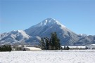
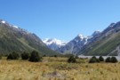
Mount Sunday
Photograph
•
Distance: 8.3km away
Little Mount Sunday (611m) is a roche moutonnée in the Rangitata Riverbed. Behind is the Black Mountain Range.
More ▶︎
Mount Potts Station campsite
Campsite
•
Standard Campsite (Private).
•
Distance: 8.9km away
Powered and tent sites located on Mount Potts Station. The lodge also offers other accommodation, and a café/restaurant and bar.
Nearby ...
More ▶︎
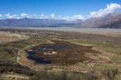
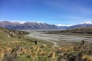
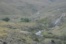
Mount Sunday Wetland
Photograph
•
Distance: 9.0km away
Fenced wetland on the Rangitata Riverbed, managed by Environment Canterbury. The wetland was fenced early 2013, and already in just ...
More ▶︎
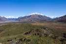
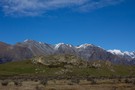
Havelock and Clyde Rivers from Mount Sunday
Photograph
•
Distance: 9.0km away
To the right is Newton Peak (2543m) between the Garden of Eden and Garden of Allah Ice Plateaux, and overlooking ...
More ▶︎
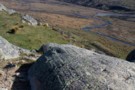
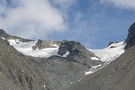
Glacial scratches on the summit of Mount Sunday
Photograph
•
Distance: 9.0km away
Mount Sunday was once underneath the Rangitata Glacier, and these scratches remain from rocks being dragged over the summit.
More ▶︎
Mount Sunday, Rangitata River
Track
•
Easy. Return by the same track.
•
Distance: 9.0km away
Short walk to a roche moutonnée, a rocky outcrop in the Rangitata River channel. The hill was used as the ...
More ▶︎
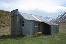
Top Hut (Te Kahui Kaupeka)
Photograph
•
Distance: 9.1km away
Top hut in the South Branch of the Ashburton River. taken 24-Oct-2011.
More ▶︎
Top Hut (Te Kahui Kaupeka)
Hut
•
Basic Hut/Bivvy (DOC). Capacity: 10.
•
Distance: 9.1km away
Top hut in the upper South Branch of the Ashburton River.
10 bunk hut built 1958 by Mt Arrowsmith Station. Taken ...
More ▶︎
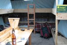
Boundary Creek Hut
Photograph
•
Distance: 9.2km away
A great little musterers hut in the Hakatere Conservation Park near the South Branch Asburton River.
More ▶︎
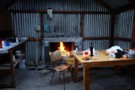
boundary creek hut
Photograph
•
Distance: 9.2km away
boundary creek hut in the distance walking up from the gorge
More ▶︎
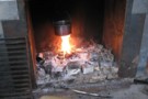
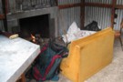
boundary creek hut
Photograph
•
Distance: 9.2km away
everyone likes a hot wash in the morning and with river water so close and a fire and billy why ...
More ▶︎
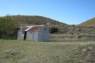
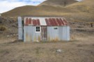
Boundary Creek Hut (Hakatere)
Hut
•
Basic Hut/Bivvy (DOC). Capacity: 8.
•
Distance: 9.2km away
boundary creek hut has 8 bunks and a concrete floor, mattresses and open fire and its very own resident mice ...
More ▶︎
Ashburton Hut?
Photograph
•
Distance: 9.4km away
Ashburton hut(?) on the other side of the flooded South Branch of the Ashburton River. photo taken 26-Oct-2011.
More ▶︎
Ashburton Hut?
Hut
•
Basic Hut/Bivvy (PVT).
•
Distance: 9.4km away
Not sure if this really is called Ashburton hut, or what state it is in. I could see it on ...
More ▶︎
Wild Man Hut
Hut
•
Private hut (PVT). Capacity: 4.
•
Distance: 9.4km away
Musterer's hut owned by Mt Arrowsmith Station. Used by hunters but the odd tramper stays as well. Doesn't seem to ...
More ▶︎
The Havelock
Article
•
Distance: 9.5km away
The Havelock River is one of the six great Canterbury rivers. As shown in Mathew's photo above, the peaks rise ...
More ▶︎
Erewhon Station - Garden Of Eden - Perth River - Whataroa
Track
•
5 – 7 days. Hard. One way.
•
Distance: 9.6km away
Erewhon Station, McCoy Hut, Wee MacGregor Glacier, Garden Of Eden, Adverse Creek, Perth River, Whataroa
More ▶︎
Whitcombe Pass & Butler Saddle
Article
•
Distance: 10.0km away
route guide attached by for Hokitika Gorge to Erewhon via Whitcombe Pass & Butler Saddle. The guide was written by ...
More ▶︎