Nearby
Thoresen's Hut
Round The Mountain (Ruapehu) - Stage 2
GPX file
•
Distance: 2.8km away
This is a pleasant two-day walk around the eastern part of the Round The Mountain (Ruapehu) Track. The walk begins ...
More ▶︎
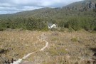
Blyth Hut, via waitonga falls
Track
•
1 – 2 days. Easy/medium. Return by the same track.
•
Distance: 2.8km away
Bush, river and tops adventure on the flanks of ruapehu in Tongariro NP. Perfect for the Whole family.
More ▶︎
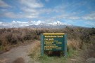
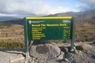
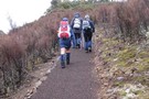
Ohakune Mountain Road
Photograph
•
Distance: 3.1km away
Entry Point for Round The Mountain Track
More ▶︎
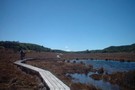
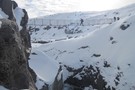
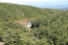
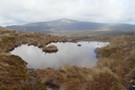
Rotokawa Tarn - Round The Mountain Track (Ruapehu)
Photograph
•
Distance: 3.6km away
Excellent viewpoint not far from Ohakune Mountain Road.
More ▶︎
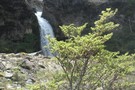
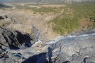
Mangaturuturu falls
Photograph
•
Distance: 3.8km away
Mangaturuturu waterfall, about 1km downstream from Mangaturuturu hut.
taken Feb 2006.
More ▶︎
Round The Mountain (Ruapehu) - Stage 3
GPX file
•
Distance: 4.5km away
This is an excellent day trip in good weather, or can be conveniently split into an overnight trip with a ...
More ▶︎
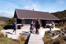
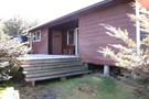
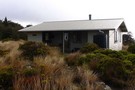
Mangaturuturu Hut
Hut
•
Standard Hut (DOC). Capacity: 8.
•
Distance: 4.7km away
Hut on the walk from Turoa Road to Lake Surprise, about 1.5 hours in.
More ▶︎
Mangaturuturu Hut
Photograph
•
Distance: 4.7km away
This hut has a long history associated with the Wanganui Tramping Club. It is now administered by DOC and is ...
More ▶︎
Round the Mountain: Ruapehu
Track
•
5 days. Easy/medium. Loop track.
•
Distance: 4.8km away
Combined with part of the Tongariro Northern Circuit, this track forms a loop around Mt Ruapehu. Combined with the other ...
More ▶︎
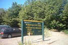
Ohakune Mountain Road
Photograph
•
Distance: 5.0km away
Entry Point for Round the Mountain toward Whakapapa
More ▶︎
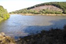
Lake Suprise
Photograph
•
Distance: 5.1km away
Lake Suprise close up. When calm it has nice reflections
More ▶︎
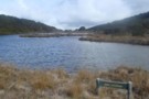
Lake Surprise
Track
•
1 day. Medium. Return via same track.
•
Distance: 5.1km away
Walk to Lake Suprise, Mountain Track
More ▶︎
Lake Suprise, looking across the Mangaturuturu Valley
Photograph
•
Distance: 5.1km away
Lake Suprise is a populat day walk from the Ohakune Mountain Rd
More ▶︎
Lupton Hut
Photograph
•
Distance: 5.1km away
Lupton Hut sits in a pleasant flat beside the stream, 10 mins below Blyth Hut
More ▶︎
Lupton Hut
Hut
•
Private hut (Wanganui High School). Capacity: 8.
•
Distance: 5.1km away
Only 10 minutes away from Blyth Hut, this is a private hut, owned by the Wanganui High School, but is ...
More ▶︎
High route to Blyth Hut
GPX file
•
Distance: 5.3km away
High route to Blyth Hut from the Turoa Road. This is a short cut on the Round the Mountain Track ...
More ▶︎
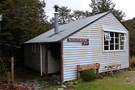
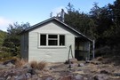
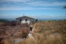
Blyth Hut
Photograph
•
Distance: 5.4km away
The front of this well appointed hut with its wide roomy deck
More ▶︎
Blyth Hut
Hut
•
Standard Hut (DOC). Capacity: 20.
•
Distance: 5.4km away
This hut is slightly off the Around Mt Ruapehu Track on a dead end track so is often bi passed.
More ▶︎
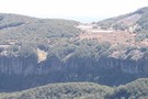
Maungaturuturu Valley
Photograph
•
Distance: 5.7km away
Steep cascade descending into Maungaturuturu Valley
More ▶︎
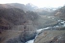
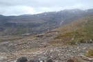
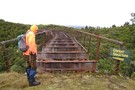
Wangaehu River Swing Bridge - Round The Mountain (Ruapehu)
Photograph
•
Distance: 6.2km away
Site of the lahar that flowed down from the crater lake.
More ▶︎
Swing Bridge - Round The Mountain (Ruapehu)
Photograph
•
Distance: 6.2km away
About 30 mins past Mangaehuehu Hut toward Ohakune Mountain Road there is a wonderful landscape of mixed bush and subalpine ...
More ▶︎

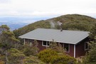
Mangaehuehu Hut - Round The Mountain (Ruapehu)
Photograph
•
Distance: 7.7km away
Excellent hut with a wonderful view.
More ▶︎
Mangaehuehu Hut
Hut
•
Standard Hut (DOC).
•
Distance: 7.7km away
On the around Mt Ruapehu Track this hut provides a welcome stop after the long day through the Rangipo desert ...
More ▶︎
Mangaehuehu hut
Photograph
•
Distance: 7.7km away
Great views from this hut over Waiouru and back up to Ohakune. Conversely, it can be very windy too
More ▶︎
Old Coach Rd - Ohakune
GPX file
•
Distance: 7.7km away
A dual use walking mountain biking track that follows the old coach rd and also visits two disused viaducts on ...
More ▶︎
Old Coach Rd - Ohakune
Track
•
0 – 1 day. Easy. One way.
•
Distance: 8.2km away
Part of the NZ cycleway recently opened by John Key. However parts of this track are quite muddy, even on ...
More ▶︎
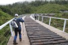
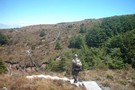
Crossing Hapuawhenua Viaduct
Photograph
•
Distance: 8.3km away
One of two disused viaducts on the Old Coach Rd. This one has been restored so you can walk or ...
More ▶︎
Mountain Tarn
Photograph
•
Distance: 8.5km away
Looking towards Hauhungatahi volcano which is thought to have erupted about 900,000 years ago, and therefore is significantly older than ...
More ▶︎

The old and the new Hapuawhenua Viaducts
Photograph
•
Distance: 8.5km away
Looking through the legs of the new viaduct towards the old one
More ▶︎
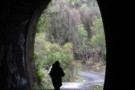
Checking out this disused tunnel
Photograph
•
Distance: 8.6km away
No trains, it was quite safe
More ▶︎
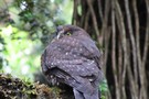
Morepork (Ruru)
Photograph
•
Distance: 8.6km away
Not often seen in daylight this small NZ native owl gets it's name from it's distinctive call
More ▶︎
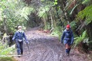
Some parts of the Old Coach Rd are very muddy
Photograph
•
Distance: 9.1km away
They must be still going to work on this bit
More ▶︎
Some parts of the Old Coach Rd are very good
Photograph
•
Distance: 9.1km away
Never seen a track so smooth
More ▶︎
Taonui Viaduct
Photograph
•
Distance: 9.5km away
One of two disused viaducts on the Old Coach Road. This one has not been restored so you cross it ...
More ▶︎
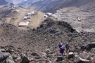
Mt Ruapehu Crater Lake
GPX file
•
Distance: 9.6km away
This trip goes up to the Crater Lake from the Top of the Bruce and then comes down via the ...
More ▶︎