Nearby
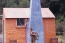
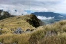
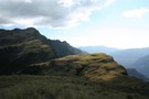
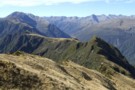
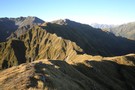
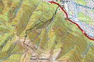
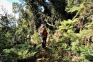
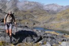
Route down off McArthur Crags to Lower Olderog biv Jan 2010
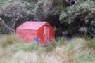
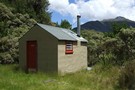
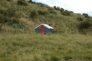
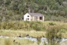
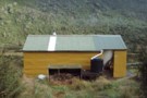
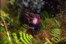
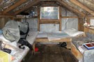
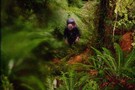
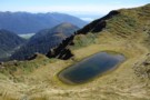
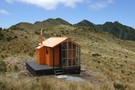
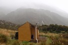
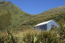
Lower Olderog biv (aka Jade biv) Feb 2009
Photograph
•
Distance: less than 100m away
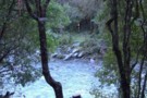
This biv is located on a bench well above the creek bed in the headwaters of Jade Creek. It is ...
More ▶︎
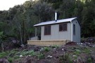
Lower Olderog biv (aka Jade biv)
Hut
•
Basic Hut/Bivvy (DOC). Capacity: 2.
•
Distance: less than 100m away
This NZFS biv dating from 1957 is located on a bench well above the creek bed in the headwaters of ...
More ▶︎
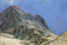
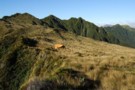
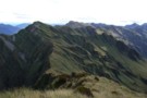
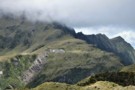
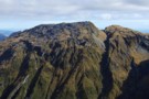
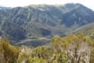
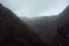
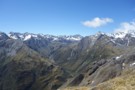
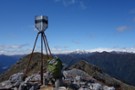
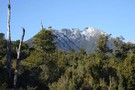
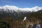
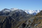
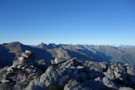
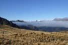
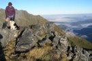
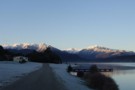
View of McArthur Crags from the Newton Range Jan 2008
Photograph
•
Distance: 1.1km away
This picture was taken from just north of the Newton Range biv. I took it to show the band of ...
More ▶︎
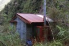
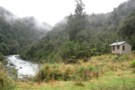
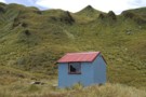
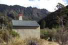
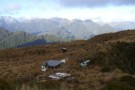
Jade Prospectors hut at Olderog/Jade Ck confluence Feb 2009
Photograph
•
Distance: 1.3km away
This hut is known by the names of both the creeks it is at the confluence of. We used to ...
More ▶︎
"Old" Lower Arahura hut (removed)
Photograph
•
Distance: 2.0km away
This photo shows the "old" Lower Arahura hut as it was in January 1976 when it had recently received a ...
More ▶︎
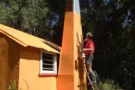
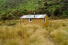
"New" Lower Arahura hut June 2010
Photograph
•
Distance: 2.0km away
A replacement DOC 6 bunk hut for the old NZFS 4 bunk hut that used to sit 30m to the ...
More ▶︎
Lower Arahura hut
Hut
•
Standard Hut (DOC). Capacity: 6.
•
Distance: 2.0km away
A new DOC 6 bunk hut that replaces the old 4 bunk NZFS hut. The new hut is 30m east ...
More ▶︎
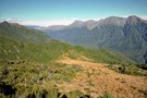
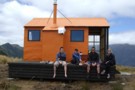
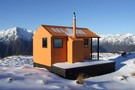
Mt Brown hut & Newton Range April 2013
Photograph
•
Distance: 2.1km away
This photo shows how the popular Mt Brown hut sits in relation to the Newton Range.
As well as tramps to ...
More ▶︎
Lower Arahura Hut
Photograph
•
Distance: 2.1km away
A nice new 6 bunk hut in the Arahura valley.
More ▶︎
Mt Kerr
Photograph
•
Distance: 2.3km away
Exploring the exposed tops above the Arahura RIver just before a front rolls in. Reached by an old NZFS track ...
More ▶︎
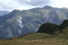
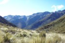
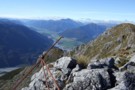
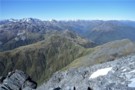
Tops route between Lower & Top Olderog bivs Jan 2010
Photograph
•
Distance: 3.4km away
This pic was taken from the summit of the McArthur Crags. The ridge running NE away from the viewers eye ...
More ▶︎
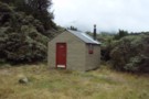
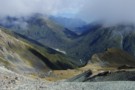
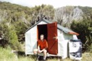
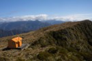
Top Olderog biv Jan 2010
Photograph
•
Distance: 3.4km away
This biv is located on the TR in the headwaters of the main branch of Olderog Creek. It is well ...
More ▶︎
Top Olderog biv
Hut
•
Basic Hut/Bivvy (DOC). Capacity: 2.
•
Distance: 3.4km away
This biv was built by the NZFS in 1971. It is located on the TR in the headwaters of the ...
More ▶︎
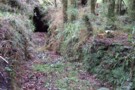
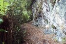
Old Water Race below Lower Arahura hut
Photograph
•
Distance: 4.7km away
Here is a photo of a remnant section of the water race that runs roughly parallel with the current track ...
More ▶︎
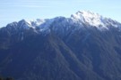
Mount Griffin (1516m)
Photograph
•
Distance: 5.1km away
The Alpine Fault passes along the northern foot of the Griffin Range, resulting in cliffs that reach up to the ...
More ▶︎
Griffin Range
Track
•
1 – 3 days. Medium. Return via same track.
•
Distance: 5.1km away
A traverse of undulating tops to the summit of Mount Griffin. Good camping next to pretty tarns, striking cliffs, and ...
More ▶︎
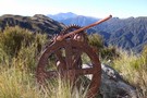
Relic from Griffin Range Serpentine Mine May 2010
Photograph
•
Distance: 5.1km away
This pic was taken at the old mine area where there are lots of relics. The perspective is looking NE ...
More ▶︎

Griffin Tops
Photograph
•
Distance: 5.1km away
Looking along the tops toward Mt.Griffin.
The Serpentine mine is in view below the top of Mt.Griffin.
West of Arthurs Pass NP
More ▶︎
A closer view of the serpentine Mine
Photograph
•
Distance: 5.1km away
Perhaps a scar on the landscape but a point of interest all the same.
Griffin Tops is perhaps a place ...
More ▶︎
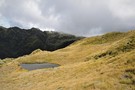
A tarn on Griffin Tops
Photograph
•
Distance: 5.1km away
On a shelf below Wilson's Knob 1291m, the southern side of Griffin Tops.
We didn't bring the Steripen so maybe ...
More ▶︎
Faultline on Mt Olson May 2013
Photograph
•
Distance: 5.2km away
This picture shows a fault line on the eastern side of Mt Olson (1603m)
Mt Olson is a hill in ...
More ▶︎
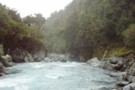
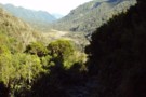
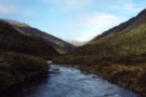
Arahura River & swingbridge
Photograph
•
Distance: 5.2km away
The swingbridge over the Arahura on the track to Newton Creek Hut.
More ▶︎
Newton Creek Hut from Arahura Pack track
Track
•
1 day. Hard. One way.
•
Distance: 5.2km away
Former forest service track that was left to overgrow and suffered further damage from snow loading in winter of 2008.
Fortunately ...
More ▶︎
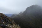
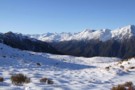
Looking eastward along the Newton Range April 2012
Photograph
•
Distance: 5.4km away
This picture was taken from a spot on the range a bit over an hour west of the bivvy. The ...
More ▶︎
Newton Range biv
Hut
•
Basic Hut/Bivvy (DOC). Capacity: 2.
•
Distance: 5.4km away
This NZFS biv built in 1962 is perched near the crest of the Newton Range. This range seperates the Arahura ...
More ▶︎
Newton Range biv Jan 2008
Photograph
•
Distance: 5.4km away
This biv is perched near the crest of the Newton Range. This range seperates the Arahura River to the north ...
More ▶︎
Arahura-Styx track
Photograph
•
Distance: 5.9km away
The Arahura - Styx track: a benched historic pack-horse track through the Arahura and Styx valleys in Westland. An easy ...
More ▶︎
Newton Creek Hut from Arahura Pack track
Article
•
Distance: 5.9km away
Formerly overgrown forest service track that could have led to underuse of lovely hut in magical setting.
More ▶︎
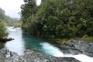
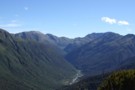
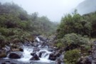
Upper Styx valley
Photograph
•
Distance: 6.0km away
Upper Styx valley and Grassy Flats, from the track over Styx Saddle.
More ▶︎
Newton Creek hut Dec 2011
Photograph
•
Distance: 6.0km away
This view of the hut looks SW. The hill in the background is Mt Newton which is on the opposite ...
More ▶︎

Route Guide: Otira to Mt Cook Village (pt 2)
Track
•
12 – 21 days. Hard. One way.
•
Distance: 6.0km away
One possible route down the main divide from Otira on the Arthur's Pass road to Mt Cook Village.
Otira Hotel ...
More ▶︎

Route Guide: Otira to Mt Cook Village (pt 1)
Track
•
12 – 21 days. Hard. One way.
•
Distance: 6.0km away
One possible route down the main divide from Otira on the Arthur's Pass road to Mt Cook Village.
Otira Hotel to ...
More ▶︎
Newton Creek Hut
Hut
•
Basic Hut/Bivvy (DOC). Capacity: 4.
•
Distance: 6.0km away
Newton Creek Hut (4 bunk, mattresses, stove, firewood, water) is a pleasant forestry hut beside Newton creek. It's drier and ...
More ▶︎
Toaroha/Zit Saddle/Kokatahi/Lathrop Saddle/Styx River Route
Track
•
3 – 5 days. Medium/hard. Loop track with a road section.
•
Distance: 6.1km away
Loop track across 2 Westland saddles, taking in some remote huts
More ▶︎
Styx Saddle
Photograph
•
Distance: 6.1km away
Styx Saddle - between the Styx and Arahura valleys in Westland. The Campbell Range forms a backdrop beyond the upper ...
More ▶︎
View from un-named Campbell Range saddle
Photograph
•
Distance: 6.2km away
This April 2013 photo was taken from the un-named Campbell Range Saddle at 1600m that is on the direct route ...
More ▶︎
Picton to Aspiring
GPX file
•
Distance: 6.3km away
An aborted alpine traverse. Picton to West Cape, but aborted at Aspiring due to real world emergencies back home. Posted ...
More ▶︎
Grassy Flat Hut
Hut
•
Standard Hut (DOC). Capacity: 12.
•
Distance: 6.3km away
Grassy Flat Hut (sleeps 12 on 2 platforms, matresses, water, stove) is a modern tramping hut with a large covered ...
More ▶︎
Grassy Flats Hut
Photograph
•
Distance: 6.4km away
Grassy Flats Hut in the upper Styx Valley, Westland. The hut lies on the easy, benched Arahura-Styx track, and is ...
More ▶︎
Mudflats Hut
Photograph
•
Distance: 6.5km away
Mudflats Hut, in the Arahura Valley, Westland.
More ▶︎
Arahura Valley
Photograph
•
Distance: 6.5km away
The Arahura Valley from the Mudflats swingbridge.
More ▶︎
Mudflats Hut
Hut
•
Standard Hut (DOC). Capacity: 6.
•
Distance: 6.5km away
Mudflats Hut (6 bunks, matresses, tank water, stove, firewood available) lies in the mid-reaches of the Arahura Valley in Westland. ...
More ▶︎
Lake Kaniere - Otira
GPX file
•
Distance: 7.6km away
from the north end of Lake Kaniere, along the west shore to the Styx river. East along the Styx to ...
More ▶︎
Griffin Creek hut August 2010
Photograph
•
Distance: 7.7km away
Here is another pic of the hut but this one shows Razorback Ridge in the headwaters of Griffin Creek as ...
More ▶︎
Griffin Creek - Rocky Creek
Track
•
2 – 3 days. Medium. Return by the same track.
•
Distance: 7.7km away
An isolated circuit west of Arthur's Pass along lightly used tracks and rocky riverbeds that are home to blue ducks.
More ▶︎
Griffin Creek Hut
Hut
•
Basic Hut/Bivvy (DOC). Capacity: 5.
•
Distance: 7.7km away
A small but lovingly maintained DOC hut in an isolated valley that is home to a number of blue ducks. ...
More ▶︎

Griffin Creek Hut
Photograph
•
Distance: 7.7km away
This homely hut is well maintained but not often visited.
More ▶︎
Griffin Creek
GPX file
•
Distance: 7.7km away
The route in to Griffin Creek Hut from the highway.
More ▶︎
Looking down the Arahura River from near Campbell biv Feb 2009
Photograph
•
Distance: 7.9km away
This pic shows the Arahura River as far as the "big bend" where it goes out of sight then it ...
More ▶︎
Campbell biv Feb 2009
Photograph
•
Distance: 7.9km away
A 1950's vintage cullers biv located on a west facing spur of the Campbell Range. From the biv there are ...
More ▶︎
Campbell biv
Hut
•
Basic Hut/Bivvy (DOC). Capacity: 2.
•
Distance: 7.9km away
A 1950's vintage cullers biv located on a west facing spur of the Campbell Range. From the biv there are ...
More ▶︎
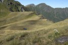
Grassy Flats
Photograph
•
Distance: 8.0km away
Grassy Flats, in the upper Styx Valley (Westland). Taken fron Browning Range Biv, 600m above.
More ▶︎
Browning Range Bivouac
Hut
•
Basic Hut/Bivvy (DOC). Capacity: 2.
•
Distance: 8.0km away
'If you're just about buggered, you're just about at Browning Biv'. The sign below the biv says it all: it's ...
More ▶︎
Browning Range Biv - almost ...
Photograph
•
Distance: 8.0km away
Browning Range Biv - almost there ...
More ▶︎
Browning Range Bivouac
Photograph
•
Distance: 8.0km away
Browning Range Bivouac, on the bush-line in the Browning Range - the hut overlooks the Styx Valley and Grassy Flat, ...
More ▶︎
Griffin Creek Hut
Photograph
•
Distance: 8.0km away
Yes I am sure this is the track.. I think.....
More ▶︎
Newton Saddle
Photograph
•
Distance: 8.0km away
Newton Saddle between Dunns Creek (hut) and Newton Creek (hut), Westland
More ▶︎
Mid Styx Hut painting March 2014
Photograph
•
Distance: 8.1km away
Volunteers have prepared & painted the hut exterior. This is just the second paint job this 1960 built hut has ...
More ▶︎
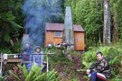
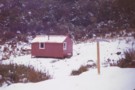
Mid Styx hut Feb 2009
Photograph
•
Distance: 8.1km away
This photo of Mid Styx hut was taken during a "Permolat" working bee when a group of volunteers worked on ...
More ▶︎
Track to Mid Styx Hut
Track
•
Easy. Loop track.
•
Distance: 8.1km away
Recently recut 40 minute track to this front country hut renovated by volunteers from the Permolat on-line community.
More ▶︎
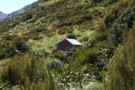
Mid Styx Hut
Article
•
Distance: 8.1km away
Our trip in to check out this hut restored by the Permolat Community
More ▶︎
Mid Styx Hut
Hut
•
Basic Hut/Bivvy (NA). Capacity: 4.
•
Distance: 8.1km away
4 person ex-NZFS hut with open fireplace on north facing terrace high above the Styx River. Renovated extensively and maintained ...
More ▶︎
Short cut to Mid Styx hut
Photograph
•
Distance: 8.1km away
This photo shows the turnoff to Mid Styx hut as described below.
Easiest access to Mid Styx hut is the Styx ...
More ▶︎
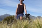
glennj & Elle dog on summit of Mt Brown April 2011
Photograph
•
Distance: 8.2km away
Summit of Mt Brown. It is the Browning Range in the background.
Yesterday was such good weather I decided to head ...
More ▶︎
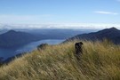
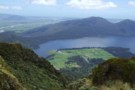
Lake Kaniere etc from top of Mt Brown April 2011
Photograph
•
Distance: 8.2km away
This pic shows Elle dog on Mt Brown with views out to the coast behind. The Lake is Kaniere and ...
More ▶︎
Browning Pass etc from Mt Browning Nov 2017
Photograph
•
Distance: 8.2km away
Looking toward Browning Pass etc from high on Mt Browning.
I climbed up from the Styx Saddle and enjoyed great ...
More ▶︎
Tarn on Tara Tama Range
Photograph
•
Distance: 8.2km away
This Westland range has many nice tarns. This is one of the nicer ones IMO. It is situated on the ...
More ▶︎
West Coast Streams
Photograph
•
Distance: 8.3km away
En-route from Harman Hut to Grassy Flat Hut. Be mindful that during heavy rain in the New Zealand bush, small ...
More ▶︎
View of Turiwhate Range from the SW
Photograph
•
Distance: 8.3km away
This photo looking up to the crest of the range was taken from a gap in the scrub zone of ...
More ▶︎
Turiwhate Range from the South West
Photograph
•
Distance: 8.3km away
On Sunday I walked up Mt Turiwhate from the SW. Historically the range has usually been accessed from the NW ...
More ▶︎
Turiwhate trig October 2020
Photograph
•
Distance: 8.4km away
A view from near the trig looking south eastward. The true highpoint of the Turiwhate Range is framed by the ...
More ▶︎
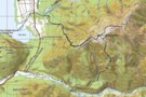
Mt Turiwhate track map
Photograph
•
Distance: 8.4km away
This map shows the gps'd route from SH73 up on to the tussock & rock main ridge leading to Mt ...
More ▶︎
Mt Turiwhate track
Track
•
1 day. Medium. Return by the same track.
•
Distance: 8.4km away
A route from SH73 at Grahams Creek, Turiwhate up to the tussock tops from where you can continue to the ...
More ▶︎
Mt Turiwhate from the Griffin Range
Photograph
•
Distance: 8.5km away
This is a July pic of the Turiwhate tops taken from the Griffin Range.
Mt Turiwhate is largely ignored by Trampers ...
More ▶︎
Mt Turiwhate July 2012
Photograph
•
Distance: 8.5km away
This pic was taken from Kawhaka Creek and looks east toward the summit of Turiwhate. (1373m)
Various creeks provide access up ...
More ▶︎
Mt Turiwhate Summit
Photograph
•
Distance: 8.5km away
Tate and Jared with the Trig after an entertaining climb up Turiwhate and across the tops
More ▶︎
View NE from Mt Turiwhate trig
Photograph
•
Distance: 8.5km away
This photo was taken autumn 2010 whilst doing a traverse of the higher bumps on the Turiwhate Range. Unlike at ...
More ▶︎
Scottys Saddle Jan 2010
Photograph
•
Distance: 8.6km away
You can see this saddle from Scottys biv. It is about a 20 - 30 minute climb to the west.
More ▶︎
Head of Griffin Creek July 2011
Photograph
•
Distance: 8.7km away
This pic was taken a few minutes along the Griffin Range route from the turnoff from the Harrington Creek - ...
More ▶︎
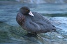
Blue Duck at the Tyndall / Styx confluence
Photograph
•
Distance: 8.8km away
Blue Duck at the Tyndall / Styx confluence
More ▶︎
Lathrop Saddle
Photograph
•
Distance: 8.9km away
Lathrop Saddle - a hanging valley cutting through the Browning Range between the Styx and Crawford valleys. A marked track ...
More ▶︎
Murk on the Turiwhate tops Sept 2012
Photograph
•
Distance: 9.0km away
This picture looking SE shows in the right hand foreground the third bump north west of the Mt Turiwhate summit ...
More ▶︎
Kellys Range & beyond from Kellys Hill July 2011
Photograph
•
Distance: 9.0km away
This pic looking SW from Kellys Hill was taken before this weeks heavy snowfalls. The dip in the foreground is ...
More ▶︎
View south from Mt Tara Tama
Photograph
•
Distance: 9.0km away
This photo shows a large expanse of Westland back country and some peaks on the Canterbury side of the main ...
More ▶︎
Mt Brown Hut
Track
•
1 – 2 days. Medium. Loop track with a road section.
•
Distance: 9.1km away
A circuit in the foothills behind Hokitika. Excellent views and a nice little hut.
More ▶︎
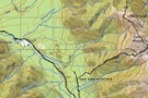
Tracks to the "New" Mt Brown hut
GPX file
•
Distance: 9.1km away
Here is a gpx file. It shows the new huts location & the routes to the hut from the Geologists ...
More ▶︎
Harman Hut
Hut
•
Standard Hut (DOC). Capacity: 6.
•
Distance: 9.1km away
Standard DOC hut at the confluence of the Harman & Arahura rivers. This hut is on the popular "3 passes" ...
More ▶︎
Harman hut August 1975
Photograph
•
Distance: 9.1km away
This pic was taken after having come down from Browning Pass. Shortly after I snapped the pic it started snowing ...
More ▶︎
View of Mt Lathrop etc. and further east
Photograph
•
Distance: 9.1km away
This photo looks east along the Browning Range. Lathrop Saddle crosses this scene in front of the prominent Mt Lathrop ...
More ▶︎
Looking SW from Mt Lathrop March 2017
Photograph
•
Distance: 9.1km away
This is the view looking out over the Crawford and Kokatahi Rivers in a south westerly direction. The Bracken snowfield ...
More ▶︎
Leaving Mt.Browns Tops
Photograph
•
Distance: 9.2km away
A good stretch of the legs. Everyone else we saw on this walk and there were a few, was staying ...
More ▶︎
Southern descent of Mt.Browns Tops
Photograph
•
Distance: 9.2km away
Moving through a boggy section of the Mt.Browns Tops route just before dropping over the edge into the creek.
That's ...
More ▶︎
Harman Hut
Photograph
•
Distance: 9.2km away
Harman Hut on a typical West Coast summer day. Pretty basic hut that comes with its own family of weka!
More ▶︎
Looking up the Styx from near the New Mt Brown hut
Photograph
•
Distance: 9.2km away
This pic taken yesterday was snapped from the tussock section below the hut whilst heading for the start of the ...
More ▶︎
Negotiating treefall - Griffin Tops track
Photograph
•
Distance: 9.3km away
It's familiar, but climbing over on the return.
Took a way around on the ascent.
More ▶︎
Mount Brown Hut
Photograph
•
Distance: 9.3km away
Perched on a cliff overlooking Lake Kaniere.
More ▶︎
The Mt Brown ridge construction site May 2010
Photograph
•
Distance: 9.3km away
Looking SW from Mt Brown ridge over top of the early stages of construction of the "new" hut.
The "old" Lower ...
More ▶︎
View out to coast from Mt Brown hut
Photograph
•
Distance: 9.3km away
This view is taken just a few steps from Mt Brown hut and looks back toward the track start and ...
More ▶︎
Lunch time at Mt Brown hut Dec 2010
Photograph
•
Distance: 9.3km away
The four younger members of the group of five of us that walked up to check out the new hut.
The ...
More ▶︎
Mt Brown hut & beyond Dec 2010
Photograph
•
Distance: 9.3km away
This hut replaces, but on a different site, the old Mt Brown hut which was removed by DOC about five ...
More ▶︎
Mt Brown Hut
Hut
•
Basic Hut/Bivvy (Mt Brown Community Hut Project). Capacity: 4.
•
Distance: 9.3km away
This hut replaces the old Mt Brown hut which was removed by DOC in 2006. The hut is in a ...
More ▶︎
Mt Brown summit & circuit routes March 2011
Photograph
•
Distance: 9.3km away
This map shows the actual track/routes overlayed in solid black lines on a Topo 50 map. The "old" Mt Brown ...
More ▶︎
View up Styx valley from Mt Brown hut June 2012
Photograph
•
Distance: 9.3km away
This photo looks up the Styx valley and was taken from outside Mt Brown hut. If you look closely you ...
More ▶︎
Mt Brown hut June 2012
Photograph
•
Distance: 9.3km away
Here is a winter time pic of the hut.
More ▶︎
Turiwhate tops Sept 2013
Photograph
•
Distance: 9.4km away
This photo is of Neil B on the Turiwhate tops about 10 minutes SE of where the TL Grahams Ck ...
More ▶︎
Scottys biv Jan 2010
Photograph
•
Distance: 9.4km away
A seldom walked to biv in a nice spot in the head basin of Scottys Creek a Taipo River tributary. ...
More ▶︎
Scottys biv
Hut
•
Basic Hut/Bivvy (DOC). Capacity: 2.
•
Distance: 9.4km away
A seldom walked to biv in a nice spot in the head basin of Scottys Creek a Taipo River tributary. ...
More ▶︎
Crossing Lathrop Saddle
Photograph
•
Distance: 9.4km away
Crossing Lathrop Saddle from the Crawford towards Browning Biv
More ▶︎
Dunns Creek
Photograph
•
Distance: 9.5km away
Dunns Creek, rough scrub on the ascent to Newton Saddle
More ▶︎
Browning Range
Photograph
•
Distance: 9.5km away
From the Browning Bivvy on the bushline above the Styx River we climbed in the dark to reach the top ...
More ▶︎
Plane Crash Memorial Mt Turiwhate
Photograph
•
Distance: 9.5km away
This photo shows the memorial to Lynch and Renton who were killed in the first fatal plane crash in Westland ...
More ▶︎
View from Hans Bay Lake Kaniere Aug 2015
Photograph
•
Distance: 9.6km away
I took this picture from beside the lake a few minutes before parking at the Mt Tuhua track carpark and ...
More ▶︎
Mt Tuhua Sept 2010
Photograph
•
Distance: 9.6km away
Yesterday morning I took advantage of the first nice day for a while to head up Mt Tuhua which is ...
More ▶︎
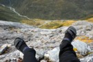
Lathrop Saddle feet dangle
Photograph
•
Distance: 9.8km away
Sitting on the edge of Lathrop. Spot the biv. Descent far right on the tussock spur. Dangling feet highly recommended.
More ▶︎