Nearby
Waipunga Falls
A Whirinaki crossing - Waikaremoana Road Summit to Rangitaiki Tavern
Track
•
6 – 10 days. Medium. One way.
•
Distance: 550m away
Majestic podocarp forest - straight-turnked trees, reaching for the sky, bearded in epiphytes, the forest floor below covered in a ...
More ▶︎
Access to the Whirinaki and Matakuhia Areas
GPX file
•
Distance: 1.2km away
Most of the forest roads in the Kaiangaroa Forest require you to have a permit. At the moment they are ...
More ▶︎
A Whirinaki crossing
GPX file
•
Distance: 5.7km away
The route of my traverse of the Whirinaki Conservation Area following approximately the main divide - or at least the ...
More ▶︎
Lower Matakuhia Hut
Hut
•
Basic Hut/Bivvy (DOC).
•
Distance: 6.9km away
This is an old hut lower down the Matakuhia Valley. It was given a new coat of paint a few ...
More ▶︎
Waipunga Forest
Place
•
Place.
•
Distance: 6.9km away
A fairly neglected area between the Whirinaki Forest and the Napier-Taupo Rd. Two old huts there and very overgrown tracks
More ▶︎
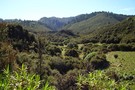
"The Landing"
Photograph
•
Distance: 6.9km away
A lovely valley on the true left of the Waipunga River.
More ▶︎
Upper Matakuhia Hut
GPX file
•
Distance: 6.9km away
This is the track to the Upper Matakuhia Hut. It is possible to go further down the valley but the ...
More ▶︎
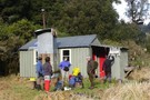
Upper Matakuhia Hut
Photograph
•
Distance: 9.2km away
A more rustic 8 bunk hut in the Matakuhia Valley
More ▶︎
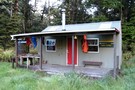
Upper Matakuhia Hut
Hut
•
Basic Hut/Bivvy (DOC). Capacity: 8.
•
Distance: 9.2km away
A more rustic hut, recently sporting a new paint job and a log fire placed where the old open fire ...
More ▶︎
Upper Matakuhia Hut
Track
•
1 – 2 days. Easy. Return via same track.
•
Distance: 9.2km away
An ideal easy overnight trip or can be done as a day trip
More ▶︎
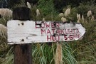
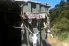
Sign at Upper Matakuhia Hut
Photograph
•
Distance: 9.2km away
This sign gives some idea of the standard of the track you are about to encounter heading downstream
More ▶︎