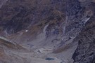
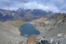
Nearby
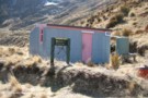
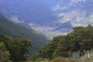
Glenorchy Lagoon
Paradise Road Glenorchy, New Zealand, Fiordland, April 2018
Photograph
•
Distance: 1.4km away
Paradise Road Glenorchy, New Zealand, Fiordland, April 2018
More ▶︎
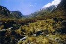
Heather Jock Hut
Track
•
1 – 2 days. Easy. Loop track.
•
Distance: 2.2km away
A gentle climb through a mining area to a small hut with panoramic mountain views.
More ▶︎
Sleepy Hollow Pass route (Caples to Dart)
Track
•
Medium/hard. One way.
•
Distance: 4.5km away
The Sleepy Hollow pass route from the mid-Caples to the Dart Valley. This can be combined with either a walk ...
More ▶︎
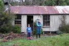
McIntyre Hut
Hut
•
Standard Hut (DOC). Capacity: 5.
•
Distance: 4.5km away
Corrugated iron miners' hut dating from the 1960s.
More ▶︎
Jean Hut
Hut
•
Overnight use prohibited (DOC).
•
Distance: 4.6km away
Historic miners' hut clad in flattened iron drums. It features a series of rocks suspended from the roof to hold ...
More ▶︎
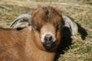
Goat kid
Photograph
•
Distance: 4.6km away
Near Jean Hut, Mount Alaska. This young goat was dozing comfortably in the sun, and quite confused about whether or ...
More ▶︎
Boozer Hut
Hut
•
Basic Hut/Bivvy (DOC).
•
Distance: 4.8km away
An historic hut named for a notorious 1930s scheelite miner. The hut is clad in flattened steel drums, and contains ...
More ▶︎
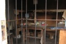
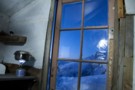
Bonnie Jean hut interior
Photograph
•
Distance: 5.0km away
Bonnie Jean hut interior. taken Sept 2015
More ▶︎
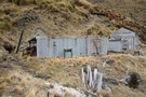
Bonnie Jean Hut
Hut
•
Overnight use prohibited (DOC).
•
Distance: 5.0km away
Built in 1943, this hut near Bonnie Jean Mine is preserved as an on-site museum. It features an old tractor ...
More ▶︎
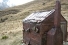
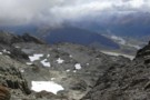
Toilet at Heather Jock Hut
Photograph
•
Distance: 5.3km away
This long drop toilet forms part of a scenic view from Heather Jock Hut.
The axle and remains of a solid ...
More ▶︎
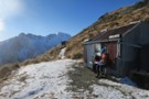
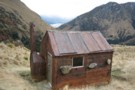
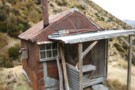
Heather Jock Hut
Photograph
•
Distance: 5.4km away
A spectacular location above Glenorchy where the old time Sheelite miners used to toil away. Reached via a track from ...
More ▶︎
Heather Jock Hut
Photograph
•
Distance: 5.4km away
Wrestling with the sticky door, August 2008.
More ▶︎
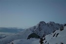
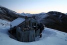
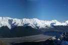
Heather Jock Hut
Photograph
•
Distance: 5.4km away
August evening with Mount McIntosh in the background.
More ▶︎
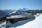
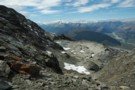
Heather Jock Hut
Hut
•
Basic Hut/Bivvy (DOC). Capacity: 3.
•
Distance: 5.4km away
A small miner's hut high on Mount Alaska, near Glenorchy. This little-used hut combines easy access with spectacular panoramic views ...
More ▶︎
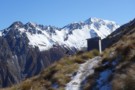
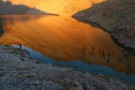
Dusk, near Heather Jock Hut
Photograph
•
Distance: 5.4km away
Looking northwest, toward the Cosmos Peaks and Mount Earnslaw.
More ▶︎
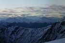
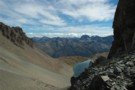
Morning view from Heather Jock Hut.
Photograph
•
Distance: 5.4km away
From left: Tooth Peak 2061m near the Greenstone River mounth, Mount Judah 1416m (foreground), Bold Peak 2118m and Mount Bonpland ...
More ▶︎
McIntosh hut
Photograph
•
Distance: 5.6km away
McIntosh hut. Mt Earnslaw in background. taken Sept 2015
More ▶︎
McIntosh Hut (Mac's Hut)
Hut
•
Basic Hut/Bivvy (DOC). Capacity: 4.
•
Distance: 5.6km away
Scheelite miners' hut high on Mount McIntosh, dated around 1915.
More ▶︎

Haast to The Divide
GPX file
•
Distance: 5.9km away
Andrew Barker's traverse 2009. From Pleasant Flat in the Haast to The Divide via Mt Aspiring National Park.
More ▶︎
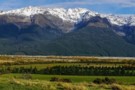
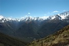
Whakaari Conservation Area
Place
•
Place. 94.00km2.
•
Distance: 6.2km away
Mountains east of Glenorchy, dotted with scheelite miners' huts and relics.
More ▶︎
Buckler Burn Forks Hut (Delapidated)
Hut
•
Derelict hut (DOC).
•
Distance: 6.2km away
This old miners' hut is located at the confluence of Wallers Creek with the Buckler Burn.
More ▶︎

Descent to Glacier Burn
Photograph
•
Distance: 6.9km away
The final descent to Glacier Burn from pt1731, on the route from the Caples valley via Sleepy Hollow.
More ▶︎
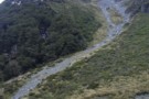
Glacier burn - ascent to sleepy hollow pass
Photograph
•
Distance: 6.9km away
From Glacier Burn to Sleepy Hollow pass: route leaves the Glacier Burn track and climbs this scree gully on the ...
More ▶︎
Sleepy Hollow
Photograph
•
Distance: 7.1km away
From near Bold Peak. Inspired by madpom, I went the opposite direction via Glacier Burn to Kay Creek
More ▶︎
Wallers Hut
Hut
•
Basic Hut/Bivvy (DOC). Capacity: 5.
•
Distance: 7.5km away
Historic corrugated iron and beech pole miners' hut in the Whakaari Conservation Area. The hut was built on Wallers Creek ...
More ▶︎
Sleepy Hollow
Photograph
•
Distance: 7.7km away
situated on the ridge between Glenorchy and Caples Valley
More ▶︎
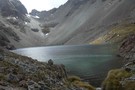
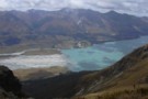
Gorge Creek / Dart Valley
Photograph
•
Distance: 7.8km away
Gorge Creek and the Dart Valley, from the Sleepy Hollow pass between the Caples and Dart valleys.
More ▶︎
Sleepy Hollow
Photograph
•
Distance: 7.8km away
Sleepy Hollow from the top of the pass into the Dart.
More ▶︎
Sleepy Hollow
Photograph
•
Distance: 7.8km away
Sleepy Hollow above the mid Caples Valley. The pass to Gorge Creek / Glacier Burn and the Dart Valley is ...
More ▶︎
Kelly's Hut
Hut
•
Basic Hut/Bivvy (DOC). Capacity: 6.
•
Distance: 8.0km away
New circular hut at point 1912 northwest of Mount Larkins.
More ▶︎
Rees Vally
Photograph
•
Distance: 8.3km away
This is a picture taken on the rees/dart track and is on day 2 of our tramp in between shelter ...
More ▶︎
![waterfall[lake face creek]track](http://tramper.nz/imgcache/1/1589-mini.jpg)
waterfall[lake face creek]track
Track
•
Easy/medium. Return via same track.
•
Distance: 8.7km away
a day walk from the waterfall on the glenorchy-queenstown road. this track takes you the base of the waterfall.
More ▶︎
Pigeon Island
Track
•
Easy. Loop track.
•
Distance: 9.2km away
A loop track on an island in Lake Wakatipu.
More ▶︎
Smithy's hut
Hut
•
Basic Hut/Bivvy (NA). Capacity: 10.
•
Distance: 9.2km away
Old ten-bunker with a tin roof, located on Pigeon Island in Lake Wakatipu.
More ▶︎
Greenstone / Caples Tracks
Track
•
4 days. Easy/medium. Loop track.
•
Distance: 9.5km away
The Greenstone and Caples Tracks are often linked together to form a circuit from the shores of Lake Wakatipu. Long ...
More ▶︎
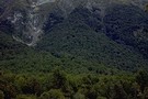
Mid Caples Valley
Photograph
•
Distance: 9.6km away
Mid Caples Valley from pt1168, just above the bushedge the way to Sleepy Hollow. Mid Caples Hut is just visible ...
More ▶︎
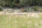
Caples Valley Fallow Deer
Photograph
•
Distance: 9.7km away
Spooked a mob of 30+ deer back in 06/07.
More ▶︎
Caples Track
Track
•
2 days. Easy/medium. One way.
•
Distance: 9.7km away
A quiet track climbing alongside the Caples River through forest and grassy flats and over a sub-alpine saddle.
More ▶︎