Nearby
Tramp from the Haast to the Blue

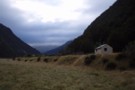
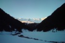
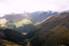
Maori Saddle
Photograph
•
Distance: less than 100m away
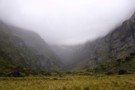
Crossing of the Main Divide from the Okuru River to the Blue River. 1245m. This photo taken from Douglas Saddle. ...
More ▶︎
Haast to The Divide
GPX file
•
Distance: 270m away
Andrew Barker's traverse 2009. From Pleasant Flat in the Haast to The Divide via Mt Aspiring National Park.
More ▶︎
Picton to Aspiring
GPX file
•
Distance: 836m away
An aborted alpine traverse. Picton to West Cape, but aborted at Aspiring due to real world emergencies back home. Posted ...
More ▶︎
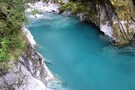
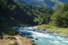
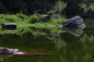
The Blue Pools
Photograph
•
Distance: 1.4km away
A bridge over the Blue river just a 10 minute nature walk from the Haast highway allows viewing of the ...
More ▶︎
Te Wāhipounamu - South West New Zealand World Heritage Area
Place
•
World Heritage Area. 26000.00km2.
•
Distance: 3.7km away
This UNESCO World Heritage Area occupies the southwestern corner of New Zealand. It includes four national parks, and covers 10% ...
More ▶︎
Pleasant Flat Campsite
Campsite
•
Basic Campsite (DOC). 30 spaces.
•
Distance: 3.8km away
Campsite by the highway just north of Haast Pass.
More ▶︎
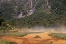
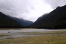
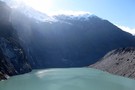
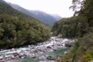
Young and Makarora Rivers
Photograph
•
Distance: 4.0km away
Confluence of the Young and Makarora Rivers near Haast Pass
More ▶︎
The Young River/Makarora River Confluence
Photograph
•
Distance: 4.1km away
This is looking West up the Young Valley. The Gillespie Pass Circuit starts here at the other side of the ...
More ▶︎
Gillespie Pass Circuit
Track
•
3 – 4 days. Medium. Loop track.
•
Distance: 4.1km away
This is a 3-4 day track that is located near Makarora at the head of Lake Wanaka. Being a loop ...
More ▶︎
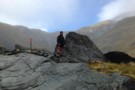
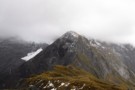
Gillespie Pass
Photograph
•
Distance: 4.1km away
Looking down at the Young side of the Pass.
More ▶︎
Where do rivers come from?
Photograph
•
Distance: 4.9km away
Wilkin North Branch toward upper lakes
More ▶︎
Wilkin Valley Track
Track
•
2 – 5 days. Easy/medium. Return by the same track.
•
Distance: 4.9km away
This stunning track is commonly tramped in conjunction with the Gillespie Pass Circuit or with the Rabbit Pass/East Matukituki traverse, ...
More ▶︎
Track to North Branch lakes
Photograph
•
Distance: 4.9km away
Shortly before reaching the Disappearing Tarn
More ▶︎
The Young River
Photograph
•
Distance: 5.1km away
The lower Young River passes through beech forest as the Gillespie Pass Circuit heads up its true left bank.
More ▶︎
Brewster track to Mt.Armstrong
Track
•
1 – 2 days. Hard. Return via same track.
•
Distance: 7.0km away
An ascent from the state hwy(SH6),just west of Haast Pass,of over 1700m to a summit on the main divide of ...
More ▶︎
Cameron(s) Hut, Makarora
Photograph
•
Distance: 7.1km away
A cozy but spacious 4-bunk hut in the Camerons Creek valley off the Makarora - taken late July 2011. Accessible ...
More ▶︎
Cameron Hut Wanaka/Makarora
Hut
•
Standard Hut (DOC). Capacity: 4.
•
Distance: 7.1km away
Great wee hut- 4 bunk, pot belly stove.
More ▶︎
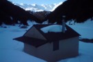
View from Cameron(s) Hut, Makarora
Photograph
•
Distance: 7.1km away
The view from a (briefly) open window in Cameron's Hut one late July evening. 3 feet of snow outside - ...
More ▶︎
Upper Burn Hut
Hut
•
Removed!
•
Distance: 8.3km away
Private Hunter Valley Station hut in the upper High Burn. Hunter Valley own or lease two flats up this valley ...
More ▶︎
DOC campsite at Young Forks
Photograph
•
Distance: 8.5km away
Located 2 minutes from the swingbridge up the Young North branch and about 2 hours from Young hut, this is ...
More ▶︎
The Head of the Young Valley
Photograph
•
Distance: 9.1km away
The Head of the valley shortly before leaving the valley floor to begin the climb to Gillespie Pass up the ...
More ▶︎
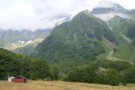
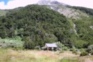
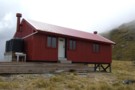
Brewster Hut
Photograph
•
Distance: 9.1km away
On the side of Mt Armstrong looking down at Brewster Hut and Haast Pass further still
More ▶︎
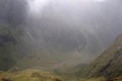
Returning to Haast Pass
Photograph
•
Distance: 9.1km away
Leaving Brewster hut for Haast pass 900M below
More ▶︎
Brewster hut Jan 2009
Photograph
•
Distance: 9.1km away
An alpine hut in the Haast Pass area between Mt Armstrong and the highway. This hut is only a few ...
More ▶︎
Brewster Hut
Hut
•
Serviced Alpine Hut (DOC). Capacity: 12.Bookings required.
•
Distance: 9.1km away
An alpine hut in the Haast Pass area between Mt Armstrong and the highway. This hut is only a few ...
More ▶︎
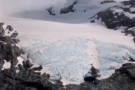
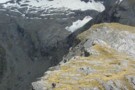
Brewster Glacier
Photograph
•
Distance: 9.6km away
Located only a 90 minute scramble away from Brewster hut, Brewster Glacier is well worth the visit especially if Mt ...
More ▶︎
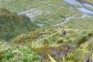
Along way up
Photograph
•
Distance: 9.6km away
The track to Gillespie Pass climbs nearly verically towards the pass. This is looking back down into the Young Valley ...
More ▶︎
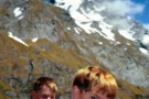
The boys, Gillespie Pass, Jan 2001
Photograph
•
Distance: 9.6km away
Aged 11 and 14, the lads proved remarkably resilient on the Wilkin/Young tramp, braving sandflies a the "Young Forks lunch ...
More ▶︎
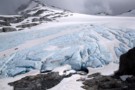
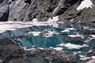
Blue ice on the snout of the Brewster Glacier
Photograph
•
Distance: 9.9km away
The ice visible at the face of the Brewster Glacier is an incredible shade of blue.
More ▶︎
Gillespie Stream and the Siberia from Gillespie Pass
Photograph
•
Distance: 9.9km away
Looking South West from the pass, the Gillespie Stream snakes its way down towards the Siberia Valley. The valley across ...
More ▶︎
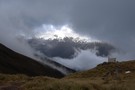
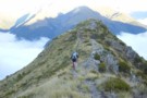
The Gillespie Saddle
Photograph
•
Distance: 9.9km away
Taken from the hightest point of the Gillespie Pass track on point 1629 looking over the saddle towards point 1726. ...
More ▶︎
Wilkins - Young (Gillespie Pass) Circuit
Track
•
3 – 4 days. Medium. One way.
•
Distance: 9.9km away
Crossing the Makarora river on foot to the Young valley. Ascending to Young Hut in the first day. 2nd Day ...
More ▶︎