Nearby
Blowhard Track
Mount Richardson Bypass Track
GPX file
•
Distance: 586m away
This track pairs with the Mount Richardson Track to form a nice loop from Glentui Bush.
More ▶︎
Mount Richardson Bypass Track
Track
•
1 day. Easy/medium. Return by the same track.
•
Distance: 586m away
This track drops from the ridge east of Mount Richardson to the Glentui Bush car park.
More ▶︎
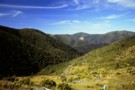
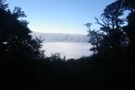
Burnt forest, Mount Richardson
Photograph
•
Distance: 593m away
Looking northeast along Blowhard Stream.
More ▶︎
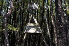
Old trig
Photograph
•
Distance: 909m away
This old wooden trig at 797m on the Blowhard Track has been outcompeted by living timber.
More ▶︎
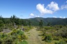
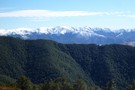
Blowhard Track to Mt Richardson
Photograph
•
Distance: 949m away
Blowhard Track to Mt Richardson
More ▶︎
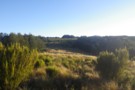
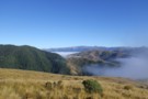
Clearings north of Mt Richardson
Photograph
•
Distance: 1.9km away
Clearings north of Mt Richardson - there's a bivvy here somewhere!
More ▶︎
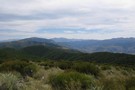
Lees Valley, Lillburn Range from Richardson
Photograph
•
Distance: 2.0km away
Lees Valley, Lillburn Range from Richardson
More ▶︎
Mt Richardson loop
Track
•
1 day. Easy. Loop track.
•
Distance: 2.2km away
Climb up steadily on a well-made track through tawhai forest and up to Mt Richardson (1047 metres). At the top ...
More ▶︎
Mount Richardson Track
GPX file
•
Distance: 2.2km away
Climb from Glentui Bush Road up to the summit of Mount Richardson (1047m).
More ▶︎
Mount Richardson Track
Track
•
1 day. Easy/medium. One way.
•
Distance: 2.2km away
Forested climb from Glentui Bush car park to the summit of Mount Richardson (1047m).
More ▶︎
Pinchgut Hut via Mt Thomas, Bobs Camp Biv
Track
•
2 – 3 days. Medium. Loop track.
•
Distance: 2.9km away
Two day tramp on the ridges around Pinchgut Valley
More ▶︎
Mt Thomas Forest
Place
•
Reserve.
•
Distance: 2.9km away
Foothill forest northwest of Oxford and Christchurch, stretching from the Ashley Gorge to the Okuku River, and including Mount Richardson ...
More ▶︎
Bob's Camp Bivvy
Track
•
1 – 2 days. Easy/medium. Loop track.
•
Distance: 3.9km away
An easy day or overnight walk through beech forest and along easy ridges to a cute and comfortable biv.
More ▶︎
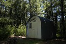
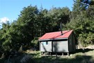
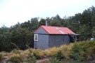
Bob's Camp Bivvy
Hut
•
Basic Hut/Bivvy (DOC). Capacity: 2.
•
Distance: 3.9km away
A cute and tidy biv with a curved corrugated iron roof. The biv is located in a small beech forest ...
More ▶︎
Okuku River - Pinchgut - Bob's Camp Bivvy - Mt Thomas
Track
•
1 – 2 days. Easy. One way.
•
Distance: 4.0km away
Nice overnighter with an easy to follow track. Possible to do in a long day if that's your thing.
More ▶︎
Pinchgut Hut via Mount Thomas summit, Forrestdale Road, and Whare Stream
Track
•
2 days. Medium. Loop track.
•
Distance: 4.2km away
A circuit route following the original track that goes to Pinchgut Hut from the Forestry block on the north face ...
More ▶︎
Kereru Track
GPX file
•
Distance: 4.3km away
Short link track in Mount Thomas Forest. Walk it as part of the Kereru Loop: Red Pine Track, Forest Track, ...
More ▶︎
Kereru Track
Track
•
Easy. One way.
•
Distance: 4.3km away
A short linking track in Mount Thomas forest. This track connects the Red Pine Track with the Wooded Gully Track ...
More ▶︎
Wooded Gully - Pinchgut Hut
Track
•
2 days. Medium. Return via same track.
•
Distance: 4.3km away
An overnight trip near Mount Thomas following unmarked trails to a comfortable hut.
More ▶︎
Forest Track
GPX file
•
Distance: 4.5km away
Short link track in Mount Thomas Forest. Walk it as part of the Forest Loop: Wooded Gully Track, Forest Track, ...
More ▶︎
Wooded Gully Campsite
Campsite
•
Basic Campsite (DOC). 50 spaces.
•
Distance: 4.7km away
Streamside camping in Mount Thomas Forest at the edge of the Canterbury foothills. Several short walks are nearby, plus longer ...
More ▶︎
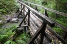
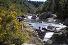
Glen Tui Nature Walk
Photograph
•
Distance: 5.0km away
First bridge after descending from picnic area
More ▶︎
Glentui Loop Track
Track
•
Easy. Loop track.
•
Distance: 5.0km away
Pleasant loop through riverside forest at the foot of Mount Richardson.
More ▶︎
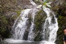
Ashley Gorge Waterfall Track
GPX file
•
Distance: 5.0km away
Extension to the loop track, leading up to a 10m waterfall on a local unnamed creek.
More ▶︎
Ashley Gorge Waterfall Track
Track
•
1 day. Easy. Return by the same track.
•
Distance: 5.8km away
This popular extension to the Ashley Gorge Loop Track leads to a 10-metre waterfall.
More ▶︎
Mount Thomas
Track
•
Easy/medium. Loop track.
•
Distance: 5.8km away
Located at the edge of the Canterbury Plains, Mount Thomas is a good day trip from Christchurch with views of ...
More ▶︎
Ashley Gorge Loop Track
GPX file
•
Distance: 6.0km away
Short walk near the Ashley Gorge Camping Ground.
More ▶︎
Ashley Gorge Loop Track
Track
•
1 day. Easy. Loop track.
•
Distance: 6.0km away
Short family walk near Ashley Gorge Holiday Park.
More ▶︎
Pancake Range from Cattle Peak Route
Photograph
•
Distance: 6.1km away
Pancake Range from Cattle Peak Route - on the way to Bob's Camp Biv
More ▶︎
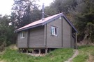
Pinchgut Hut
Hut
•
Standard Hut (DOC). Capacity: 9.
•
Distance: 7.0km away
A small but tidy hut in a frosty clearing behind Mount Thomas. Since the hut is small, near Christchurch and ...
More ▶︎
Pinchgut Track (Ōkūkū River - Pinchgut Hut)
Track
•
1 – 2 days. Easy/medium. Return by the same track.
•
Distance: 7.0km away
An easy day walk or overnighter to a hut in the foothills behind Mt Thomas
More ▶︎

Black Hill
Track
•
2 days. Easy/medium. Return by the same track.
•
Distance: 8.4km away
A straightforward overnighter in the dry beech forests around Mount Oxford.
More ▶︎
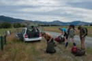
Getting started
Photograph
•
Distance: 8.4km away
The traditional start: five trampers and packs crowd into a compact car then drive 1.5 hours. Townshend Track in the ...
More ▶︎
Ladbrooks Hill Track from Ashley Gorge
Track
•
Easy. Return by the same track.
•
Distance: 8.5km away
500m developed track to take you to the tops in the Mt Thomas forest and possible further circuits.
More ▶︎
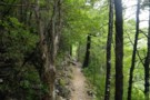
Pinchgut Track
Photograph
•
Distance: 9.6km away
The Pinchgut track is a good benched sidle track into Pinchgut Hut. 3 DOC hrs.
More ▶︎
Youngman Stream Track
GPX file
•
Distance: 9.7km away
Valley walk up to Youngman Stream Hut.
More ▶︎
Youngman Stream Track
Track
•
1 day. Easy/medium. Return by the same track.
•
Distance: 9.7km away
Steady sidle up the Rakahuri / Ashley River from the Lees Valley to Youngman Stream Hut.
More ▶︎