Nearby
Toetoe Biv
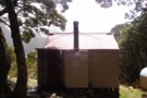
Creswicke Flat Hut
Hut
•
Basic Hut/Bivvy (DOC). Capacity: 4.
•
Distance: 3.5km away
Iron hut next to an airstrip on flats of the Landsborough River.
More ▶︎
Mad Pom's latest adventure. Part 2
Article
•
Distance: 3.6km away
A trip to the head on the landsborough, and all that ensues. Part two.
More ▶︎
Fraser / Cheswicke Airstrip
Photograph
•
Distance: 3.6km away
Fraser / Cheswicke Airstrip, Landsborough
More ▶︎
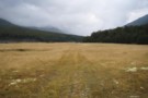
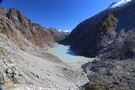
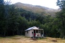
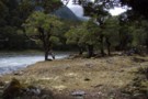
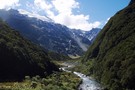
The Landsborough at Cheswicke Flat, Fraser Hut
Photograph
•
Distance: 3.6km away
The Landsborough at Cheswicke Flat, Fraser Hut
More ▶︎
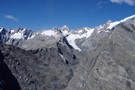
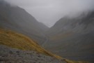
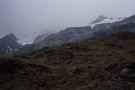
The Landsborough from Brodrick Pass
Photograph
•
Distance: 3.6km away
The Landsborough in cloud. From the ridgeline descent from Brodrick pass via MacKenzie Creek
More ▶︎
Mad Pom's latest adventure
Article
•
Distance: 3.6km away
A trip to the heads of the Landsborough ... and all that ensues.
More ▶︎
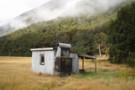
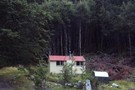
Fraser Hut (Landsborough)
Hut
•
Basic Hut/Bivvy (DOC). Capacity: 4.
•
Distance: 3.6km away
Fraser Hut in the Landsborough is a basic 4-bunk hut on river terraces at the base of the Broderick Pass. ...
More ▶︎
Mad Pom's latest Adventure - Part 5
Article
•
Distance: 3.6km away
A trip to the head of the Landsborough - and all that ensues.
Part 5 - Heroes and Angels.
More ▶︎
Mad Pom's latest Adventure - part 4
Article
•
Distance: 3.6km away
A trip to the head of the Landsborough - and all that ensues.
Part 4: the longest walk.
More ▶︎
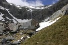
Marks Flat Rock Biv
Rock bivouac
•
Distance: 5.3km away
Marks Flat is a wide basin beneath Mount Hooker. It is strewn with boulders, one of which affords shelter.
More ▶︎
Brodrick Pass
Photograph
•
Distance: 7.1km away
Brodrick Pass from Brodrick Hut, an easy low route into the mid-reaches of the Landsbrorough from the Nth Hxley
More ▶︎
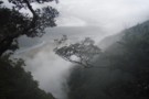
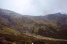
MacKenzie Creek from Brodrick Pass
Photograph
•
Distance: 7.1km away
MacKenzie creek descends towards the Landsborough from Brodrick pass. This hanging valley drops vertically from the limit of this photo ...
More ▶︎
Hāwea Conservation Park
Place
•
Conservation Park. 1050.00km2.
•
Distance: 7.5km away
A large park at the head of Lake Hāwea between Mount Aspiring National Park and Ahuriri Conservation Park.
More ▶︎
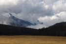
Mt Strauchon from Brodrick
Photograph
•
Distance: 7.5km away
Mt Strauchon vanishes into cloud from the Brodrick Pass
More ▶︎
Hooker Landsborough Wilderness Area
Place
•
Wilderness Area. 410.00km2.
•
Distance: 7.6km away
Remote peaks and valleys around Mount Hooker (2652m) and the head of the Landsborough River. The area borders Westland National ...
More ▶︎
McKerrow Creek camp spots
Photograph
•
Distance: 8.0km away
Typical of camp spots beside most side creeks up the Landsborough. With only 2 huts, this is canvas country - ...
More ▶︎
Cirque wall in Kea creek, below Elcho Pass.
Photograph
•
Distance: 8.4km away
We found a ok route along ledges to the true left of the waterfall, only had one steep drop about ...
More ▶︎
Huxley North Branch
Photograph
•
Distance: 9.0km away
The North Branch of the Huxley towards Brodrick Hut and Mt Strauchon
More ▶︎
Brodrick Hut
Hut
•
Standard Hut (DOC). Capacity: 6.
•
Distance: 9.0km away
Brodrick Hut (sleeps 6, tank water, stove, firewood available) is a 1960's forestry hut at the base of the Brodrick ...
More ▶︎
Huxley Valley
Track
•
2 days. Easy/medium. Return via same track.
•
Distance: 9.1km away
Easy walking at the head of Lake Ohau.
More ▶︎