Nearby
100 Acres Plateau
100 Acres Plateau
Photograph
•
Distance: less than 100m away
Tarns and camping sites galore.
More ▶︎
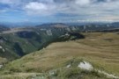
Thousand Acres Plateau
Track
•
3 – 4 days. Medium. Return via same track.
•
Distance: 2.0km away
Explore a cliff-edged tussock plateau near Murchison.
More ▶︎
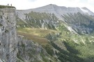
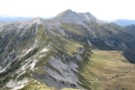
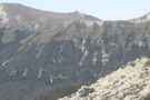
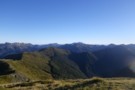
Panorama from the Needle
Photograph
•
Distance: 2.0km away
Haystack, Larrikin Creek, 100 Acres Plateau.
More ▶︎
Mt Haystack from the Needle
Photograph
•
Distance: 2.1km away
The Needle-Haystack ridge looks quite a daunting prospect. The key is to regain the ridge top as quick as possible ...
More ▶︎
1000 Acre Plateau
GPX file
•
Distance: 2.3km away
The route from The Matiri Road end up to the Plateau, Larrikins Hut and on to climb the Needle
More ▶︎
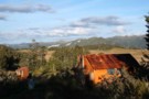
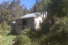
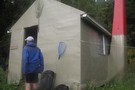
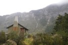
Larrikin's Creek Hut
Photograph
•
Distance: 2.4km away
This is a great hut, fireplace, 4 bunks and serviced by DOC. I recommend a partner and a bottle of ...
More ▶︎
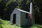
Larrikin Creek Hut
Photograph
•
Distance: 2.4km away
A small but tidy hut near the Hundred Acres Plateau.
More ▶︎
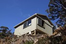
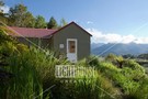
Larrikin Creek Hut
Hut
•
Standard Hut (DOC). Capacity: 4.
•
Distance: 2.4km away
A tidy hut located in forest margin at the foot of the Haystack, a small peak with striking mudstone banding. ...
More ▶︎
Larrikin Hut to Hurricane Hut via Mt Haystack
Photograph
•
Distance: 2.7km away
This pic is taken from point 1442 looking back towards Mt Haystack. The point on the skyline is 1411 on ...
More ▶︎
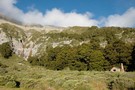
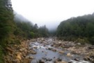
Boscawen Saddle, Rough Creek route
Article
•
Distance: 4.1km away
A description of a weekend tramp up the Nina River, over Boscawen Saddle, sidling to Robinson Saddle, down one branch ...
More ▶︎
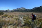
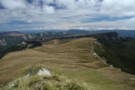
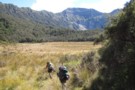
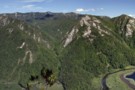
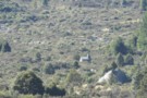
Crossing the plateau.
Photograph
•
Distance: 5.4km away
The long walk across the Thousand Acres Plateau, toward the distant Needle and Haystack.
More ▶︎
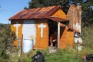
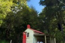
Poor Pete's Hut
Hut
•
Basic Hut/Bivvy (DOC). Capacity: 2.
•
Distance: 6.7km away
A new biv replaced the old orange shack in February 2012. The hut features a conservatory-style foyer with a transparent ...
More ▶︎

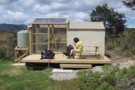
Poor Pete's NEW hut
Photograph
•
Distance: 6.7km away
Installed January 2012. Still 2 bunk but room for 3 or 4 in extension at a squeeze! Nice new water ...
More ▶︎
Poor Pete NEW hut, January 2012
Photograph
•
Distance: 6.7km away
Very nice hut now. The new one is the refurbished 'Baigent's Biv' (wherever that was! lol ) with an interesting ...
More ▶︎
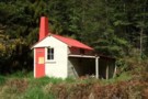
Poor Pete's Hut
Photograph
•
Distance: 6.7km away
A battered shack but has a couple of comfortable bunks inside. Probably welcome shelter for no more than 2 people
More ▶︎
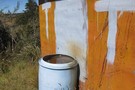
Water supply at Poor Pete's
Photograph
•
Distance: 6.7km away
Primitive but it works and the water is clean
More ▶︎
Poor Pete's Hut
Photograph
•
Distance: 6.7km away
Slightly delapidated but not in a pretty way, Poor Pete's Hut is in a good location, overlooking the Thousand Acres ...
More ▶︎
Matiri Valley to Wangapeka Saddle
GPX file
•
Distance: 6.9km away
An interesting cross country trip in Kahurangi National Park
More ▶︎
McConchies Hut
Hut
•
Standard Hut (DOC). Capacity: 4.
•
Distance: 7.0km away
Standard 4 bunk hut in the Matiri Valley, Kahurangi National Park.
More ▶︎
Matiri Valley to Wangapeka Saddle
Track
•
4 – 6 days. Medium. One way.
•
Distance: 7.1km away
An interesting cross country trip in Kahurangi National Park involving a stretch of unmarked ridge travel
More ▶︎
Nice clearings in the Upper Matiri
Photograph
•
Distance: 7.4km away
After a lot of bush and river travel, this clearing make a pleasant respite
More ▶︎
Mt Arthur to Murchison
GPX file
•
Distance: 7.5km away
track from Mt Atrhur Tablelands to Murchison via Wangapeka Saddle, Nugget Knob and the Matiri Valley
More ▶︎
Old Ghost Road
GPX file
•
Distance: 8.3km away
A GPS track of the Old Ghost Road November 2017
More ▶︎
Goat Creek Hut (DOC)
Photograph
•
Distance: 9.0km away
In 2013 this historic hut built in 1957 was cleaned up. The old graffiti wall is still intact, and the ...
More ▶︎
Goat Creek hut Sept 2009
Photograph
•
Distance: 9.0km away
A charming hut situated on the TR of the South Branch of the Mokihinui River at the confluence with Goat ...
More ▶︎
Goat Creek hut
Hut
•
Basic Hut/Bivvy (DOC). Capacity: 4.
•
Distance: 9.0km away
A charming hut situated on the TR of the South Branch of the Mokihinui River at the confluence with Goat ...
More ▶︎
Old Ghost Road
Track
•
4 – 5 days. Easy/medium. One way.
•
Distance: 9.1km away
This new trail links the ghost town of Lyell with the Mokihinui River. The first section is open from 2 ...
More ▶︎
Mokihinui Forks Hut - renovated
Photograph
•
Distance: 9.1km away
In 2013 DOC doubled the size of Mok Forks Hut which includes more bunks inside a new foyer. Total of ...
More ▶︎
Mokihinui Forks Hut
Photograph
•
Distance: 9.1km away
Mokihinui Forks Hut sits over the south branch of the Mokihinui River, just before it meets the north branch.
More ▶︎
Mokihinui Forks Hut
Hut
•
Basic Hut/Bivvy (DOC). Capacity: 10.
•
Distance: 9.1km away
Mokihinui Forks Hut sits over the south branch of the Mokihinui River, just before it meets the north branch.
The hut ...
More ▶︎
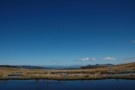
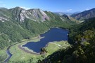
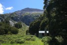
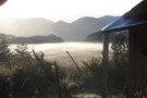
Lake Matiri
Photograph
•
Distance: 9.9km away
A bird's eye view, from the steep climb onto the Thousand Acres Plateau.
More ▶︎
Lake Matiri panorama
Photograph
•
Distance: 9.9km away
Views of Lake Matiri and the unnamed peak 1358m on the way up to the Thousand Acres Plateau.
More ▶︎
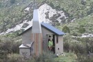
Hurricane Hut
Photograph
•
Distance: 9.9km away
Hurricane Hut - tumbled limestone bluffs beyond
More ▶︎
Hurricane Hut
Photograph
•
Distance: 9.9km away
The hut can be seen from well down the flat, before you het there.
More ▶︎
Hurricane Hut
Photograph
•
Distance: 9.9km away
A compact little hut in the head of the Matiri Valley
More ▶︎
Hurricane Hut
Hut
•
Standard Hut (DOC). Capacity: 4.
•
Distance: 9.9km away
A pleasant 4 bunker at the head of the Matiri
More ▶︎